Dec 16+17, 2011, Rainier, Muir x2 and Sunset POWDER
12/15/11
WA Cascades West Slopes South (Mt Rainier)
10245
5
Yes, there really was powder up there, and it really was some nice skiing -- on one of these two days at least.
(photo by PVK)
Friday, Dec 16, 2011: Sunset Powder
After the driest first 2 weeks of December in Seattle history, the snow had finally arrived in the Northwest -- sort of: 6" of new snow at Paradise overnight as of Thursday the 15th, with another 1.5" recorded during the day. This modest amount was nevertheless the most new snowfall of any measurement site in the Cascades, with most other sites getting only 2-4" total new. And the first snowfall over a fraction of an inch at Paradise since 6" fell on Nov 30, capping off a very snowy November.
The Rainier forecast for Friday the 16th looked marginal, vacillating between "partly sunny" to "mostly cloudy" in recent updates, with moderately high winds at 10000 ft too. But the UW model showed a strong clearing trend during the day, with nearly complete clearing between 1pm and 4pm with winds at 10000 ft also diminishing significantly during that period, and freezing levels over 10000 ft. Seemed like a perfect window for a sunset ski, and Paresh was keen to join me for that.
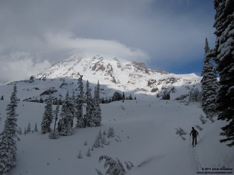
We got a very leisurely start, skinning up from Paradise at 10:40am under mostly cloudy skies, but with a partial view of the lenticular-capped Mountain and Muir Snowfield from under the clouds. Large plumes of snow could be seen blowing east off of Anvil Rock, evidence of very strong winds above 9000 ft. Broke trail all the way from the parking lot in the 4-8" of new snow, still powdery despite temps in the mid-30s at Paradise. A prudent application before we started of Nikwax Ski Skin Proof on the skins and Rain-X on the topsheets provided relief from what would have been fierce skin-glopping and snow-carrying conditions, the Nikwax working very well, the Rain-X somewhat.
The new powder extended all the way up Pan Point, well bonded to the crust underneath and providing an easy skin up Pan Face, and powder even continued on past the Pebble Creek rolls, except for a few short windblown sections that had been cleared to bare crust. Still very thin snow cover at Pebble Creek, with a short rocky (but skinnable) section to negotiate, but looking way better than the winter ridge route which still appeared to be impassably bare for skis. Above 7500 ft, the new powder slowly faded out and by 8500 ft it was mostly windpack, along with large patches of exposed icy crust.
By now, the clouds had almost entirely cleared out just as the UW model predicted, the lenticular cap slowly dissipating too in scenic fashion. The winds were definitely diminishing too, although occasional strong gusts from the NW and SW had us hunkering down repeatedly for brief periods until the blowing snow passed by. Ski crampons were very helpful above 9000 ft as has often been the case lately.
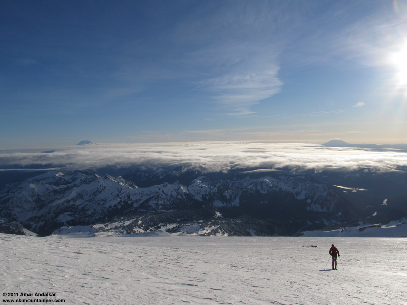
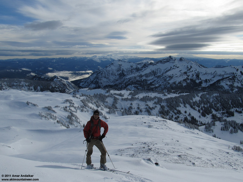
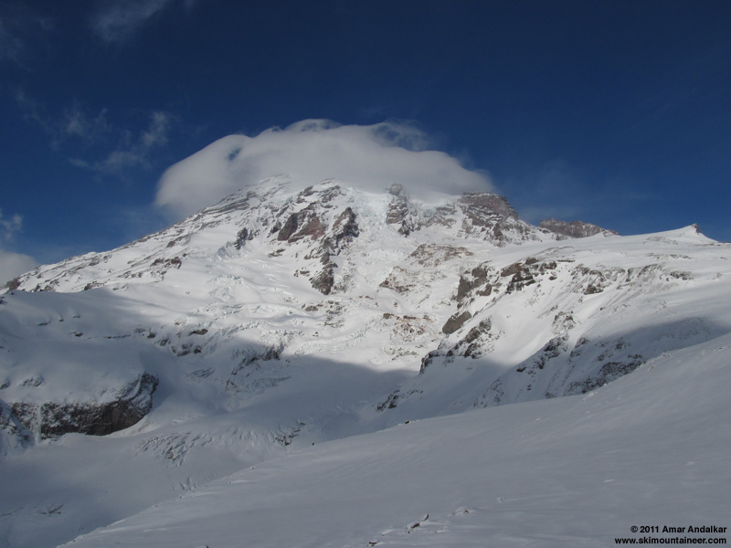
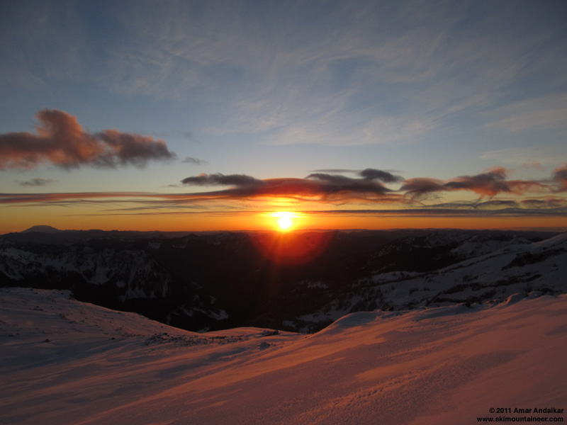
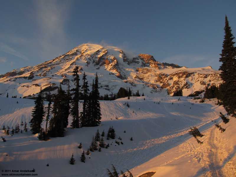
Arrived at Muir just before 3pm, in complete solitude and still having seen no one else at all since leaving the parking lot. An amazing display of wispy flowing clouds could be seen to the south, flowing in interleaving layers from the west through the gaps between the Cascade peaks and piling up noticeably against the west side of Mount Adams.
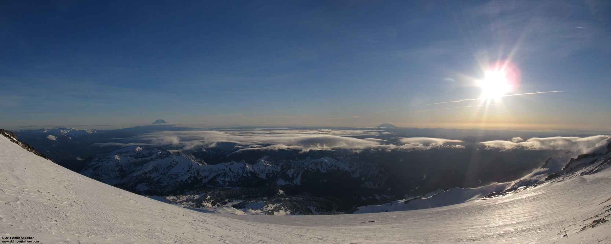
(click for double-size version)
Three-shot panorama looking south from Camp Muir, with Mounts Adams, Hood, and Saint Helens in the distance above the wispy cloud layers.
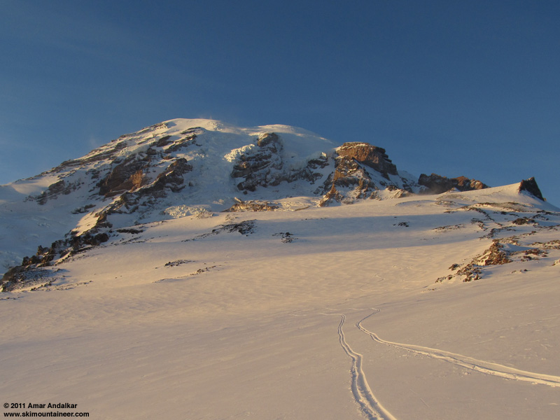
Enjoyed the sunshine for a while on the mostly-wind-protected south side of the Muir public shelter, we had time to kill since we wanted to watch the sunset on the way down. Finally skied down around 3:30pm, on tolerable fingers of windpack between large areas of icy crust. Chatted with a snowboarder ascending on snowshoes near 9000 ft, the only other person we would see all day, he would switch over and descend shortly as sunset neared. Headed over to the 8400 ft entrance of Nisqually Chute to take a look down it, but it was too firm and crusty at the entrance for our liking. With conditions in the Chute unknown (could have been sweet powder, or hideous windslab or breakable crust), we decided to pass on that. A good choice since the skiing became much better on the lower Snowfield below 8000 ft, smooth medium-density powder, somewhat windpacked in spots, really nice in others.
There was even decent powder on the Pebble Creek rolls, despite the winds sculpting and sharpening the crest of the lowest roll throughout the day.
(photo by PVK)
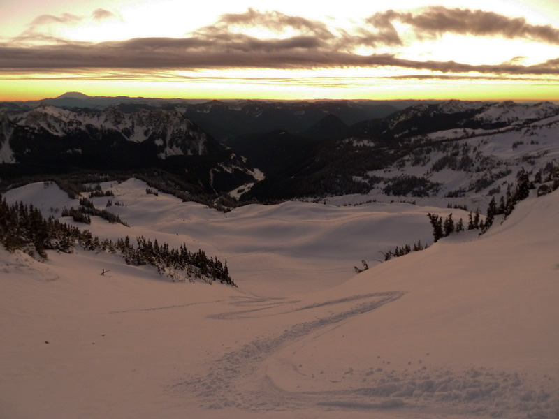
We found a nice spot to linger above Panorama Point and watched the sunset, still enhanced by wispy flowing clouds.

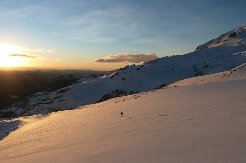
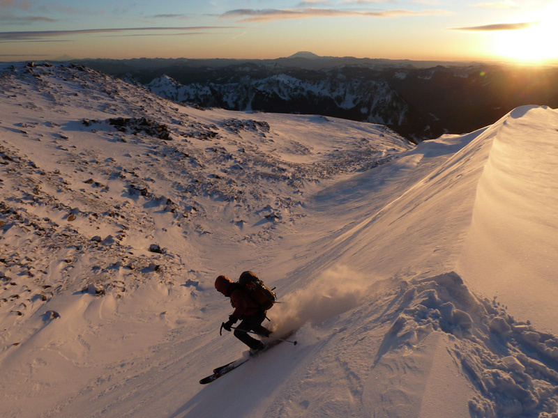
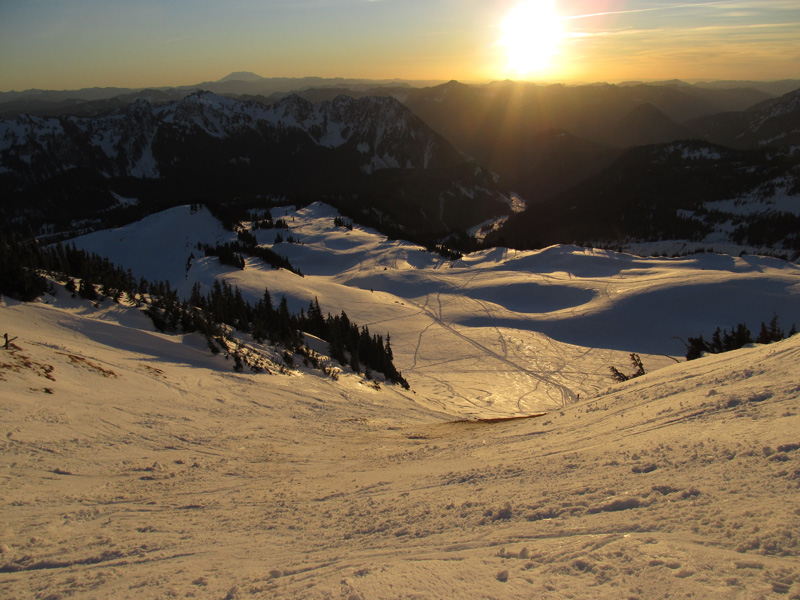
The nicest turns of the day were on Panorama Face, 6" of untracked powder in the twilight about 15 minutes after sunset.
(photo by PVK)
Surprisingly even the snow below there was still powdery all the way back to Paradise, protected from crusting by the cloudiness despite temps above freezing all day. A quick cruise back to the parking lot with plenty of twilight to spare.

Great to enjoy such fine conditions and company along with another sunset ski on my 100th ski day of 2011, the first time I've ever broken the century mark in any calendar year or one-year period.
[tt]MOUNT RAINIER RECREATIONAL FORECAST
NATIONAL WEATHER SERVICE SEATTLE WA
410 AM PST FRI DEC 16 2011
SYNOPSIS...HIGH PRESSURE ALOFT WILL PREVAIL OVER THE REGION THROUGH SATURDAY. LOOK FOR A WEAK LOW PRESSURE SYSTEM TO MOVE ACROSS THE AREA ON SUNDAY.
TODAY...MOSTLY CLOUDY. FREEZING LEVEL 8500 FEET.
TONIGHT...PARTLY CLOUDY. FREEZING LEVEL 9500 FEET.
SATURDAY...MOSTLY SUNNY. FREEZING LEVEL 10000 FEET.
SATURDAY NIGHT...INCREASING CLOUDS. A CHANCE OF RAIN OR SNOW. SNOW LEVEL LOWERING TO 5000 FEET.
SUNDAY...RAIN OR SNOW LIKELY. SNOW LEVEL 4000 FEET.
SUNDAY NIGHT...MOSTLY CLOUDY. A CHANCE OF SHOWERS IN THE EVENING. SNOW LEVEL 3000 FEET.
MONDAY...PARTLY SUNNY. FREEZING LEVEL 6500 FEET.
MONDAY NIGHT...MOSTLY CLOUDY. FREEZING LEVEL 6500 FEET.
TUESDAY...CLOUDY WITH A CHANCE OF RAIN OR SNOW. SNOW LEVEL 5500 FEET.
TUESDAY NIGHT...CLOUDY WITH A CHANCE OF RAIN OR SNOW. SNOW LEVEL LOWERING TO 3000 FEET.
WEDNESDAY AND WEDNESDAY NIGHT...CLOUDY WITH A CHANCE OF SHOWERS. SNOW LEVEL 2000 FEET.
THURSDAY...CLOUDY WITH A CHANCE OF SHOWERS. SNOW LEVEL 3000 FEET.
TEMPERATURE AND WIND FORECASTS FOR SELECTED LOCATIONS.
TODAY TONIGHT SAT SAT SUN
NIGHT
SUMMIT (14411 FT) 14 15 15 4 5
NW 45 W 34 SW 45 W 66 NW 40
CAMP MUIR(10188 FT) 27 31 30 18 21
NW 15 W 16 SW 40 W 50 NW 10
PARADISE (5420 FT) 39 31 40 27 31
CALM E 3 E 4 SE 2 W 3
LONGMIRE (2700 FT) 41 30 42 33 38
CALM CALM CALM CALM CALM
[/tt]
Saturday, Dec 17, 2011: Turned to Chowder
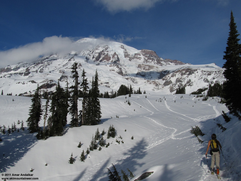
With the forecast for Saturday looking good and another partner eager to head for Muir, I once again found myself headed back to Paradise the next day. An even later start this time, skinning up from Paradise just after noon under mostly sunny skies and very warm temps. Yesterday's powder was completely gone though, already transformed into heavy wet snow by the day's sunshine and warmth.
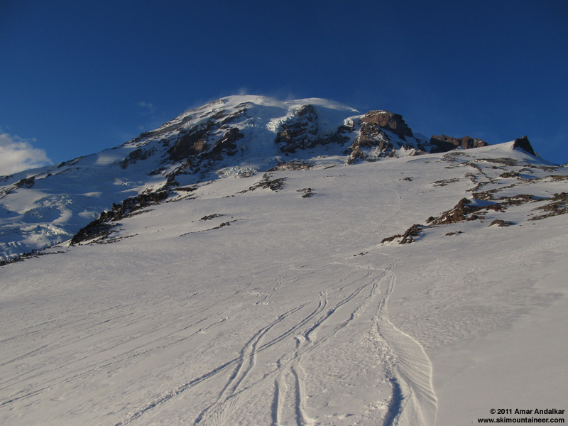
With no trail-breaking required today, we enjoyed a quick cruise up the route, reaching Muir in just under 3 hours despite again needing ski crampons above 9000 ft and again dealing with gusty SW winds. Many more skiers out on Saturday than Friday, we watched perhaps a dozen descending at various times as we ascended, but Camp Muir had emptied out by the time we arrived after 3pm.
Skied down after a brief break inside the shelter, the snow conditions above 8000 ft were nearly the same as the day before, perhaps a bit worse, still long fingers of windpack separating large icy patches. Below 8000 ft, ski conditions were much worse. Everything had been hammered to windpack, except a few small patches of corn snow on the sunniest SW aspects near 7500 ft and on the Pebble Creek rolls, where the winds had stripped the new snow down to the old frozen corn crust and the day's sunshine had managed to soften it.
Heavy wet tracked-out mank down Pan Face today, along with large bare grassy areas, yesterday's untracked pow now a distant memory. Even worse below that, the wet snow was crusting over on the flatter slopes down to Paradise as the sun dropped lower, making for very cautious going to avoid knee injury. We were relieved to be back safely to Paradise a few minutes before sunset, it would have been treacherously unsafe to try to stay up high and watch the sunset this day given the rapidly freezing sun crust. Still always great to have gotten another day of sun and views and exercise up on the Mountain, despite the much deteriorated snow conditions.
[tt]MOUNT RAINIER RECREATIONAL FORECAST
NATIONAL WEATHER SERVICE SEATTLE WA
400 AM PST SAT DEC 17 2011
SYNOPSIS...AN UPPER RIDGE WILL PROVIDE DRY WEATHER TODAY WITH RELATIVELY MILD TEMPERATURES. A WEAK FRONTAL SYSTEM WILL BRING SOME PRECIPITATION TONIGHT AND SUNDAY...WITH TOTAL SNOW ACCUMULATIONS GENERALLY IN THE 1 TO 3 INCH RANGE ACROSS MOUNT RAINIER NATIONAL PARK. AFTER DRY WEATHER AGAIN MONDAY...ANOTHER SYSTEM WILL ARRIVE ABOUT TUESDAY. RELATIVELY DRY WEATHER WILL LIKELY PREVAIL LATE NEXT WEEK AS WELL.
SATURDAY...MOSTLY SUNNY. FREEZING LEVEL 9500 FEET.
SATURDAY NIGHT...RAIN AND SNOW LIKELY. SNOW LEVEL 7000 FEET.
SUNDAY...CLOUDY. A CHANCE OF SNOW AND RAIN IN THE MORNING...THEN A CHANCE OF RAIN AND SNOW SHOWERS IN THE AFTERNOON. SNOW LEVEL 4000 FEET.
SUNDAY NIGHT...MOSTLY CLOUDY. A CHANCE OF SHOWERS IN THE EVENING. SNOW LEVEL 3500 FEET.
MONDAY...PARTLY SUNNY. FREEZING LEVEL 5500 FEET.
MONDAY NIGHT...MOSTLY CLOUDY. FREEZING LEVEL 5000 FEET.
TUESDAY...CLOUDY WITH A CHANCE OF RAIN AND SNOW. SNOW LEVEL 5500 FEET.
TUESDAY NIGHT...SNOW AND RAIN LIKELY. SNOW LEVEL 3500 FEET.
WEDNESDAY...CLOUDY WITH A CHANCE OF SHOWERS. SNOW LEVEL 2000 FEET.
WEDNESDAY NIGHT...CLOUDY WITH A CHANCE OF SHOWERS. SNOW LEVEL 2500 FEET.
THURSDAY...CLOUDY WITH A CHANCE OF SHOWERS. SNOW LEVEL 3000 FEET.
THURSDAY NIGHT...MOSTLY CLOUDY. FREEZING LEVEL 4000 FEET.
FRIDAY...CLOUDY. FREEZING LEVEL 4000 FEET.
TEMPERATURE AND WIND FORECASTS FOR SELECTED LOCATIONS.
SAT SAT SUN SUN MON
NIGHT NIGHT
SUMMIT (14411 FT) 14 11 7 10 17
SW 45 W 70 NW 40 NW 40 NW 40
CAMP MUIR(10188 FT) 29 22 21 25 25
W 25 W 50 NW 35 NW 35 NW 35
PARADISE (5420 FT) 45 31 37 26 39
SE 10 SW 10 W 5 NE 5 NE 5
LONGMIRE (2700 FT) 43 30 36 29 37
E 5 S 5 W 5 NE 5 NE 5
[/tt]
(photo by PVK)
Friday, Dec 16, 2011: Sunset Powder
After the driest first 2 weeks of December in Seattle history, the snow had finally arrived in the Northwest -- sort of: 6" of new snow at Paradise overnight as of Thursday the 15th, with another 1.5" recorded during the day. This modest amount was nevertheless the most new snowfall of any measurement site in the Cascades, with most other sites getting only 2-4" total new. And the first snowfall over a fraction of an inch at Paradise since 6" fell on Nov 30, capping off a very snowy November.
The Rainier forecast for Friday the 16th looked marginal, vacillating between "partly sunny" to "mostly cloudy" in recent updates, with moderately high winds at 10000 ft too. But the UW model showed a strong clearing trend during the day, with nearly complete clearing between 1pm and 4pm with winds at 10000 ft also diminishing significantly during that period, and freezing levels over 10000 ft. Seemed like a perfect window for a sunset ski, and Paresh was keen to join me for that.
We got a very leisurely start, skinning up from Paradise at 10:40am under mostly cloudy skies, but with a partial view of the lenticular-capped Mountain and Muir Snowfield from under the clouds. Large plumes of snow could be seen blowing east off of Anvil Rock, evidence of very strong winds above 9000 ft. Broke trail all the way from the parking lot in the 4-8" of new snow, still powdery despite temps in the mid-30s at Paradise. A prudent application before we started of Nikwax Ski Skin Proof on the skins and Rain-X on the topsheets provided relief from what would have been fierce skin-glopping and snow-carrying conditions, the Nikwax working very well, the Rain-X somewhat.
The new powder extended all the way up Pan Point, well bonded to the crust underneath and providing an easy skin up Pan Face, and powder even continued on past the Pebble Creek rolls, except for a few short windblown sections that had been cleared to bare crust. Still very thin snow cover at Pebble Creek, with a short rocky (but skinnable) section to negotiate, but looking way better than the winter ridge route which still appeared to be impassably bare for skis. Above 7500 ft, the new powder slowly faded out and by 8500 ft it was mostly windpack, along with large patches of exposed icy crust.
By now, the clouds had almost entirely cleared out just as the UW model predicted, the lenticular cap slowly dissipating too in scenic fashion. The winds were definitely diminishing too, although occasional strong gusts from the NW and SW had us hunkering down repeatedly for brief periods until the blowing snow passed by. Ski crampons were very helpful above 9000 ft as has often been the case lately.
Arrived at Muir just before 3pm, in complete solitude and still having seen no one else at all since leaving the parking lot. An amazing display of wispy flowing clouds could be seen to the south, flowing in interleaving layers from the west through the gaps between the Cascade peaks and piling up noticeably against the west side of Mount Adams.
(click for double-size version)
Three-shot panorama looking south from Camp Muir, with Mounts Adams, Hood, and Saint Helens in the distance above the wispy cloud layers.
Enjoyed the sunshine for a while on the mostly-wind-protected south side of the Muir public shelter, we had time to kill since we wanted to watch the sunset on the way down. Finally skied down around 3:30pm, on tolerable fingers of windpack between large areas of icy crust. Chatted with a snowboarder ascending on snowshoes near 9000 ft, the only other person we would see all day, he would switch over and descend shortly as sunset neared. Headed over to the 8400 ft entrance of Nisqually Chute to take a look down it, but it was too firm and crusty at the entrance for our liking. With conditions in the Chute unknown (could have been sweet powder, or hideous windslab or breakable crust), we decided to pass on that. A good choice since the skiing became much better on the lower Snowfield below 8000 ft, smooth medium-density powder, somewhat windpacked in spots, really nice in others.
There was even decent powder on the Pebble Creek rolls, despite the winds sculpting and sharpening the crest of the lowest roll throughout the day.
(photo by PVK)
We found a nice spot to linger above Panorama Point and watched the sunset, still enhanced by wispy flowing clouds.
The nicest turns of the day were on Panorama Face, 6" of untracked powder in the twilight about 15 minutes after sunset.
(photo by PVK)
Surprisingly even the snow below there was still powdery all the way back to Paradise, protected from crusting by the cloudiness despite temps above freezing all day. A quick cruise back to the parking lot with plenty of twilight to spare.
Great to enjoy such fine conditions and company along with another sunset ski on my 100th ski day of 2011, the first time I've ever broken the century mark in any calendar year or one-year period.
[tt]MOUNT RAINIER RECREATIONAL FORECAST
NATIONAL WEATHER SERVICE SEATTLE WA
410 AM PST FRI DEC 16 2011
SYNOPSIS...HIGH PRESSURE ALOFT WILL PREVAIL OVER THE REGION THROUGH SATURDAY. LOOK FOR A WEAK LOW PRESSURE SYSTEM TO MOVE ACROSS THE AREA ON SUNDAY.
TODAY...MOSTLY CLOUDY. FREEZING LEVEL 8500 FEET.
TONIGHT...PARTLY CLOUDY. FREEZING LEVEL 9500 FEET.
SATURDAY...MOSTLY SUNNY. FREEZING LEVEL 10000 FEET.
SATURDAY NIGHT...INCREASING CLOUDS. A CHANCE OF RAIN OR SNOW. SNOW LEVEL LOWERING TO 5000 FEET.
SUNDAY...RAIN OR SNOW LIKELY. SNOW LEVEL 4000 FEET.
SUNDAY NIGHT...MOSTLY CLOUDY. A CHANCE OF SHOWERS IN THE EVENING. SNOW LEVEL 3000 FEET.
MONDAY...PARTLY SUNNY. FREEZING LEVEL 6500 FEET.
MONDAY NIGHT...MOSTLY CLOUDY. FREEZING LEVEL 6500 FEET.
TUESDAY...CLOUDY WITH A CHANCE OF RAIN OR SNOW. SNOW LEVEL 5500 FEET.
TUESDAY NIGHT...CLOUDY WITH A CHANCE OF RAIN OR SNOW. SNOW LEVEL LOWERING TO 3000 FEET.
WEDNESDAY AND WEDNESDAY NIGHT...CLOUDY WITH A CHANCE OF SHOWERS. SNOW LEVEL 2000 FEET.
THURSDAY...CLOUDY WITH A CHANCE OF SHOWERS. SNOW LEVEL 3000 FEET.
TEMPERATURE AND WIND FORECASTS FOR SELECTED LOCATIONS.
TODAY TONIGHT SAT SAT SUN
NIGHT
SUMMIT (14411 FT) 14 15 15 4 5
NW 45 W 34 SW 45 W 66 NW 40
CAMP MUIR(10188 FT) 27 31 30 18 21
NW 15 W 16 SW 40 W 50 NW 10
PARADISE (5420 FT) 39 31 40 27 31
CALM E 3 E 4 SE 2 W 3
LONGMIRE (2700 FT) 41 30 42 33 38
CALM CALM CALM CALM CALM
[/tt]
Saturday, Dec 17, 2011: Turned to Chowder
With the forecast for Saturday looking good and another partner eager to head for Muir, I once again found myself headed back to Paradise the next day. An even later start this time, skinning up from Paradise just after noon under mostly sunny skies and very warm temps. Yesterday's powder was completely gone though, already transformed into heavy wet snow by the day's sunshine and warmth.
With no trail-breaking required today, we enjoyed a quick cruise up the route, reaching Muir in just under 3 hours despite again needing ski crampons above 9000 ft and again dealing with gusty SW winds. Many more skiers out on Saturday than Friday, we watched perhaps a dozen descending at various times as we ascended, but Camp Muir had emptied out by the time we arrived after 3pm.
Skied down after a brief break inside the shelter, the snow conditions above 8000 ft were nearly the same as the day before, perhaps a bit worse, still long fingers of windpack separating large icy patches. Below 8000 ft, ski conditions were much worse. Everything had been hammered to windpack, except a few small patches of corn snow on the sunniest SW aspects near 7500 ft and on the Pebble Creek rolls, where the winds had stripped the new snow down to the old frozen corn crust and the day's sunshine had managed to soften it.
Heavy wet tracked-out mank down Pan Face today, along with large bare grassy areas, yesterday's untracked pow now a distant memory. Even worse below that, the wet snow was crusting over on the flatter slopes down to Paradise as the sun dropped lower, making for very cautious going to avoid knee injury. We were relieved to be back safely to Paradise a few minutes before sunset, it would have been treacherously unsafe to try to stay up high and watch the sunset this day given the rapidly freezing sun crust. Still always great to have gotten another day of sun and views and exercise up on the Mountain, despite the much deteriorated snow conditions.
[tt]MOUNT RAINIER RECREATIONAL FORECAST
NATIONAL WEATHER SERVICE SEATTLE WA
400 AM PST SAT DEC 17 2011
SYNOPSIS...AN UPPER RIDGE WILL PROVIDE DRY WEATHER TODAY WITH RELATIVELY MILD TEMPERATURES. A WEAK FRONTAL SYSTEM WILL BRING SOME PRECIPITATION TONIGHT AND SUNDAY...WITH TOTAL SNOW ACCUMULATIONS GENERALLY IN THE 1 TO 3 INCH RANGE ACROSS MOUNT RAINIER NATIONAL PARK. AFTER DRY WEATHER AGAIN MONDAY...ANOTHER SYSTEM WILL ARRIVE ABOUT TUESDAY. RELATIVELY DRY WEATHER WILL LIKELY PREVAIL LATE NEXT WEEK AS WELL.
SATURDAY...MOSTLY SUNNY. FREEZING LEVEL 9500 FEET.
SATURDAY NIGHT...RAIN AND SNOW LIKELY. SNOW LEVEL 7000 FEET.
SUNDAY...CLOUDY. A CHANCE OF SNOW AND RAIN IN THE MORNING...THEN A CHANCE OF RAIN AND SNOW SHOWERS IN THE AFTERNOON. SNOW LEVEL 4000 FEET.
SUNDAY NIGHT...MOSTLY CLOUDY. A CHANCE OF SHOWERS IN THE EVENING. SNOW LEVEL 3500 FEET.
MONDAY...PARTLY SUNNY. FREEZING LEVEL 5500 FEET.
MONDAY NIGHT...MOSTLY CLOUDY. FREEZING LEVEL 5000 FEET.
TUESDAY...CLOUDY WITH A CHANCE OF RAIN AND SNOW. SNOW LEVEL 5500 FEET.
TUESDAY NIGHT...SNOW AND RAIN LIKELY. SNOW LEVEL 3500 FEET.
WEDNESDAY...CLOUDY WITH A CHANCE OF SHOWERS. SNOW LEVEL 2000 FEET.
WEDNESDAY NIGHT...CLOUDY WITH A CHANCE OF SHOWERS. SNOW LEVEL 2500 FEET.
THURSDAY...CLOUDY WITH A CHANCE OF SHOWERS. SNOW LEVEL 3000 FEET.
THURSDAY NIGHT...MOSTLY CLOUDY. FREEZING LEVEL 4000 FEET.
FRIDAY...CLOUDY. FREEZING LEVEL 4000 FEET.
TEMPERATURE AND WIND FORECASTS FOR SELECTED LOCATIONS.
SAT SAT SUN SUN MON
NIGHT NIGHT
SUMMIT (14411 FT) 14 11 7 10 17
SW 45 W 70 NW 40 NW 40 NW 40
CAMP MUIR(10188 FT) 29 22 21 25 25
W 25 W 50 NW 35 NW 35 NW 35
PARADISE (5420 FT) 45 31 37 26 39
SE 10 SW 10 W 5 NE 5 NE 5
LONGMIRE (2700 FT) 43 30 36 29 37
E 5 S 5 W 5 NE 5 NE 5
[/tt]
Thanks for setting the track to Pan Point on friday. Us oldsters sure appreciated it for our nordic tour to Glacier vista .
I kinda thought the snow dried out somewhat during the course of the day.
I kinda thought the snow dried out somewhat during the course of the day.
author=Amar Andalkar link=topic=22838.msg97299#msg97299 date=1324337915]
Nice sunset and cool lens flare.
Thank you, Amar, for putting together such nice trip reports. I have been inspired to come out of longtime lurk mode to say so. In addition to your excellent photographs, I really appreciate your thoughtful and articulate observations.
Great day, drinking the alpine nectar with you Amar. Thanks for the great company, the fine TR, & beautiful pictures. Skiing muir snowfield in the light show of that sunset was sublime. I have to agree with Gregg_C, you are a weather rock star - way to read the UW charts!
Quote by Amar: "Great to enjoy such fine conditions and company along with another sunset ski on my 100th ski day of 2011, the first time I've ever broken the century mark in any calendar year or one-year period."
Congratulations on your century mark. That's a goal usually obtained by the unemployed or retired folks. Welcome to the club. ;)
Congratulations on your century mark. That's a goal usually obtained by the unemployed or retired folks. Welcome to the club. ;)
author=Zap link=topic=22838.msg97336#msg97336 date=1324396976]
Congratulations on your century mark. That's a goal usually obtained by the unemployed or retired folks. Welcome to the club. ;)
Or by full time ski instructors making minimum wage... ahh, 2010.
Nice report Amar. We skied out from Glacier Vista area just after the sunset. Given the refreezing crust, we did lots of traversing and little turning :)
Our photos from the day: http://radkaandchris.smugmug.com/Skiing/Muir-Snowfield-December-17/20644944_DvSkd2#1636796397_XnBK68q
Reply to this TR
Please login first: