August 15, 2012, Mt Baker, Squak Still Spectacular
8/15/12
WA Cascades West Slopes North (Mt Baker)
9525
4
Another near-perfect day, another amazing ski descent of Baker via the Squak Glacier in blue sky, bright sunshine, and total solitude. Snow conditions remain excellent with semi-smooth corn snow, crevasses are a non-issue on the Squak Glacier itself and have not gotten worse during the past 3 weeks, BUT: the crevasses on the upper part of the route along the east side of the Roman Wall above 9800 ft have gotten much worse, the current bootpack has some very scary and unsafe crossings -- we were very glad to have roped up for this part. Much safer end-runs are available for the sketchy crossings, and the bootpack needs to be rerouted extensively to take those instead. There was still continuous skiable snow from the summit down to below 5200 ft via the midsummer route which follows the glacial drainage west of Crag View, great snow coverage for mid-August.

Three-shot panorama / multiple exposure of sweet corn turns down the Roman Wall.
Since my previous
Looking down from the summit at the glory and Brocken spectre in the misty clouds, with Pugh's east side glacier visible far below.
See
Another view later as the clouds dissipated, with the glory and Brocken spectre along with Glacier Peak in the distance.
For Baker the next day, we planned a 6am departure from Seattle, a 9am start from the trailhead and a summit around 4pm, but it was almost 10am by the time we headed up the trail (maybe we should have planned to camp at the Schriebers Meadow trailhead after Pugh, instead of going home). Lingering soreness from the 5500 ft of mostly-steep descent on foot at Pugh (my first hike without skis of 2012) definitely slowed us down all day. We stayed on the Scott Paul Trail almost a mile past the 4600 ft saddle, knowing from a recent report that the snow was no longer continuous up the ridge from there. Instead we went up one of the standard midsummer approaches via the moraine just before the first glacial river crossing near 5000 ft, reaching continuous skiable snow at 5150 ft that way.

The ski-length chunk of snow which collapsed underfoot into the stream near 5200 ft.
We skinned up the valley of that glacial stream just west of Crag View, on thin snow in places beside the stream. At one point a ski-length section of snow collapsed underfoot into the stream as I skinned across, but it was not hazardous and Juya could still follow across the fallen block.

Looking up the glacial stream valley towards the Squak Glacier and the blue glacial ice at its terminus from near 5400 ft.
We headed for the cliff of blue glacial ice which marks the 6600 ft terminus of this western portion of the Squak Glacier, with a cool downslope breeze keeping things comfortable on an intensely sunny day. The snow was wide and continuous past the left (west) side of the blue ice, but much too steep to skin, so we went around to the right. There was a small discontinuity where we crossed about 20 ft of bare rocks on foot, followed by skinning across perhaps 50 ft of bare blue glacial ice -- it was very roughly textured with surprisingly good traction on skins.

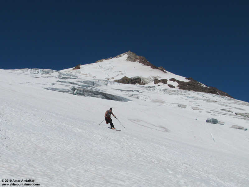
The rest of the route up the Squak Glacier from this point up to the junction with the Easton route at 9400 ft is in amazing shape, no real crevasse problems at all, and we did not even consider putting on harnesses or roping up. The usual crux crevasse at 8800 ft has barely changed over the last 3 weeks, the huge fat ramp around its left end is still good, and in fact on the steeper slope below that down to 8400 ft, there are actually a lot less sags and thin cracks than there were on July 28. Somehow the glacial motion has sealed up the incipient cracks in this area -- highly unusual, I don't think I've ever seen that happen before on any glacier that I've skied multiple times during a single summer. From 8800 to 9400 ft, there are a number of crevasses to cross, but all have solid fat bridges which have not gotten worse over the last 3 weeks.

Skinning across a snow bridge near 9200 ft.
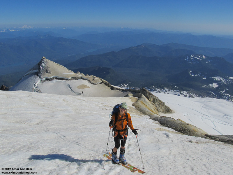
Past the Sherman Crater saddle, where the route steepens near 9800 ft, we debated whether to keep skinning, or switch to booting with crampons and rope up. We decided on the latter, which was a very good decision. The bootpack crossed several crevasses on poor snow bridges, with open holes through them, and one in particular near 10300 ft was extremely sketchy: Juya went across first, with trepidation but without incident, but I punched a foot through into a mini-crack before the main crack -- which was just a huge gaping cavern with a foot-wide gap in the bridge and a badly overhanging, thin upper lip to step onto. I crawled across this part on all fours, for better weight distribution and less chance of collapsing the lip. This was the real crux on this day, truly scary, especially in a 2-person rope team with no one else around at all. We saw no one else all day after we passed a group of 8 hikers just a few minutes from the car -- complete solitude which was welcome and enjoyable, but also increased the potential consequences of any crevasse fall greatly.

Looking up at the Roman Wall from near 9400 ft, with the true summit Grant Peak visible through the gap in the crater rim at right.
However, by heading well left (west) of the current bootpack, that crevasse and most of the others on the upper face could have been avoided with reasonable, much safer end-runs. The bootpack may have been good when it was set many days or even weeks ago after the last snowfall, but it is now in a terrible, needlessly unsafe location and in need of a major reroute. We did leave the bootpack and end-run a couple of the crevasses above that crux.
We switched back to skins above 10500 ft where the angle lessens after the route crosses about 10 ft of bare ground. We cruised over to Grant Peak around 5:20pm, with skiable snow still extending within about 5 vertical feet of the true summit.
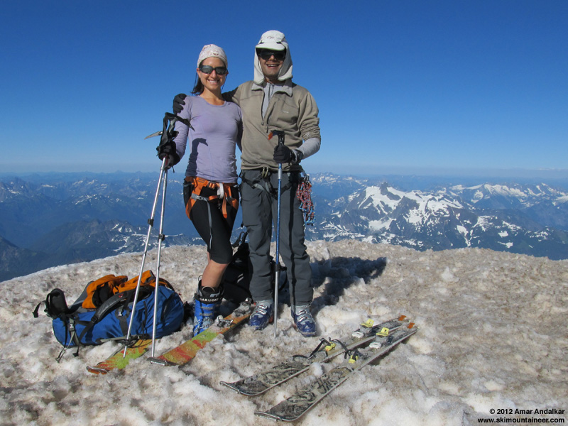
It was so nice up there, just a light breeze 0-10 mph, and temperature way over 40 °F. Juya was so happy that she was doing cartwheels on the summit:

(click for double-size version)
Seven-shot 180° panorama (vertical camera, surprising that it stitched so nicely) looking down the Park Headwall, Park Glacier, and Boulder-Park Cleaver from the summit.
We skied down just before 6pm, with smooth softened corn on the traverse around the summit dome and down the Roman Wall. We stayed well west (skier's right) of the bootpack, which had totally continuous snow without any bare section near 10500 ft as on the bootpack, and skied down without any sketchy crevasse crossings at all, just a few obvious sags to ski quickly across.

Smooth corn on the Roman Wall. (photo by JG)
We also stayed to the right as much as possible near the bottom of the wall to avoid the raised tracks and old-boot-print-suncups from 10000-9700 ft, which was by far the roughest snow of the day (see the earlier photo, looking up from 9400 ft). Below that, it was back to sweet smooth corn.

Four-shot panorama / multiple exposure of sweet corn turns past a crevasse on the Squak Glacier.

Skiing around the usual crux (although not this day) crevasse near 8800 ft.
The snow on the Squak Glacier was very well softened, easy to carve through the modest runnels and suncups like butter. Best of all, the snow was nicely slippery, not sticky at all on any part of the descent. Late afternoon and evening ski runs in fully-consolidated midsummer snow conditions are so amazing.

A large number of ice worms were visible on the glacier this day, something which I rarely see on the Squak, probably because they don't come to the surface until the sun's intensity is dropping rapidly as evening nears. Near 7000 ft, we aimed towards the right (west) side of the steep rollover which we knew held the bare blue ice slope of the glacier's terminus. We skied the nice steep pitch to the right of the ice, 45+ degrees for a couple hundred feet.

Skiing down the terminus of this lobe of the Squak Glacier, with our ascent route shown in blue.
Then just a quick cruise down the valley, the moderate suncups were softened enough to ski fine. A few spots beside the creek are getting very thin below 5400 ft, but down to that elevation the snow should stay continuous for several more days, maybe over a week.

The block of snow which had collapsed underfoot into the creek near 5200 ft had melted completely during the day, so we had to walk for a few feet to get around that spot, before skiing the last stretch of snow down to our shoes. A short walk down the moraine intersected the climber's trail back to the Scott Paul Trail, and about 80 minutes total hiking brought us back to the car by 8:20pm, with plenty of daylight to spare. Surprisingly, there were almost no bugs again today, at the trailhead or anywhere along the trail, highly unusual for mid-August in the Cascades. Not sure why bug season is not fully underway yet, but it's great not to have them.

Mount Baker delivers once again in the stellar summer of 2012, still providing over 5600 vert of mostly great skiing for about 7500 ft of total gain. Gotta keep skiing it while it's so good.
Three-shot panorama / multiple exposure of sweet corn turns down the Roman Wall.
Since my previous
Looking down from the summit at the glory and Brocken spectre in the misty clouds, with Pugh's east side glacier visible far below.
See
Another view later as the clouds dissipated, with the glory and Brocken spectre along with Glacier Peak in the distance.
For Baker the next day, we planned a 6am departure from Seattle, a 9am start from the trailhead and a summit around 4pm, but it was almost 10am by the time we headed up the trail (maybe we should have planned to camp at the Schriebers Meadow trailhead after Pugh, instead of going home). Lingering soreness from the 5500 ft of mostly-steep descent on foot at Pugh (my first hike without skis of 2012) definitely slowed us down all day. We stayed on the Scott Paul Trail almost a mile past the 4600 ft saddle, knowing from a recent report that the snow was no longer continuous up the ridge from there. Instead we went up one of the standard midsummer approaches via the moraine just before the first glacial river crossing near 5000 ft, reaching continuous skiable snow at 5150 ft that way.
The ski-length chunk of snow which collapsed underfoot into the stream near 5200 ft.
We skinned up the valley of that glacial stream just west of Crag View, on thin snow in places beside the stream. At one point a ski-length section of snow collapsed underfoot into the stream as I skinned across, but it was not hazardous and Juya could still follow across the fallen block.
Looking up the glacial stream valley towards the Squak Glacier and the blue glacial ice at its terminus from near 5400 ft.
We headed for the cliff of blue glacial ice which marks the 6600 ft terminus of this western portion of the Squak Glacier, with a cool downslope breeze keeping things comfortable on an intensely sunny day. The snow was wide and continuous past the left (west) side of the blue ice, but much too steep to skin, so we went around to the right. There was a small discontinuity where we crossed about 20 ft of bare rocks on foot, followed by skinning across perhaps 50 ft of bare blue glacial ice -- it was very roughly textured with surprisingly good traction on skins.
The rest of the route up the Squak Glacier from this point up to the junction with the Easton route at 9400 ft is in amazing shape, no real crevasse problems at all, and we did not even consider putting on harnesses or roping up. The usual crux crevasse at 8800 ft has barely changed over the last 3 weeks, the huge fat ramp around its left end is still good, and in fact on the steeper slope below that down to 8400 ft, there are actually a lot less sags and thin cracks than there were on July 28. Somehow the glacial motion has sealed up the incipient cracks in this area -- highly unusual, I don't think I've ever seen that happen before on any glacier that I've skied multiple times during a single summer. From 8800 to 9400 ft, there are a number of crevasses to cross, but all have solid fat bridges which have not gotten worse over the last 3 weeks.
Skinning across a snow bridge near 9200 ft.
Past the Sherman Crater saddle, where the route steepens near 9800 ft, we debated whether to keep skinning, or switch to booting with crampons and rope up. We decided on the latter, which was a very good decision. The bootpack crossed several crevasses on poor snow bridges, with open holes through them, and one in particular near 10300 ft was extremely sketchy: Juya went across first, with trepidation but without incident, but I punched a foot through into a mini-crack before the main crack -- which was just a huge gaping cavern with a foot-wide gap in the bridge and a badly overhanging, thin upper lip to step onto. I crawled across this part on all fours, for better weight distribution and less chance of collapsing the lip. This was the real crux on this day, truly scary, especially in a 2-person rope team with no one else around at all. We saw no one else all day after we passed a group of 8 hikers just a few minutes from the car -- complete solitude which was welcome and enjoyable, but also increased the potential consequences of any crevasse fall greatly.
Looking up at the Roman Wall from near 9400 ft, with the true summit Grant Peak visible through the gap in the crater rim at right.
However, by heading well left (west) of the current bootpack, that crevasse and most of the others on the upper face could have been avoided with reasonable, much safer end-runs. The bootpack may have been good when it was set many days or even weeks ago after the last snowfall, but it is now in a terrible, needlessly unsafe location and in need of a major reroute. We did leave the bootpack and end-run a couple of the crevasses above that crux.
We switched back to skins above 10500 ft where the angle lessens after the route crosses about 10 ft of bare ground. We cruised over to Grant Peak around 5:20pm, with skiable snow still extending within about 5 vertical feet of the true summit.
It was so nice up there, just a light breeze 0-10 mph, and temperature way over 40 °F. Juya was so happy that she was doing cartwheels on the summit:
(click for double-size version)
Seven-shot 180° panorama (vertical camera, surprising that it stitched so nicely) looking down the Park Headwall, Park Glacier, and Boulder-Park Cleaver from the summit.
We skied down just before 6pm, with smooth softened corn on the traverse around the summit dome and down the Roman Wall. We stayed well west (skier's right) of the bootpack, which had totally continuous snow without any bare section near 10500 ft as on the bootpack, and skied down without any sketchy crevasse crossings at all, just a few obvious sags to ski quickly across.
Smooth corn on the Roman Wall. (photo by JG)
We also stayed to the right as much as possible near the bottom of the wall to avoid the raised tracks and old-boot-print-suncups from 10000-9700 ft, which was by far the roughest snow of the day (see the earlier photo, looking up from 9400 ft). Below that, it was back to sweet smooth corn.
Four-shot panorama / multiple exposure of sweet corn turns past a crevasse on the Squak Glacier.
Skiing around the usual crux (although not this day) crevasse near 8800 ft.
The snow on the Squak Glacier was very well softened, easy to carve through the modest runnels and suncups like butter. Best of all, the snow was nicely slippery, not sticky at all on any part of the descent. Late afternoon and evening ski runs in fully-consolidated midsummer snow conditions are so amazing.
A large number of ice worms were visible on the glacier this day, something which I rarely see on the Squak, probably because they don't come to the surface until the sun's intensity is dropping rapidly as evening nears. Near 7000 ft, we aimed towards the right (west) side of the steep rollover which we knew held the bare blue ice slope of the glacier's terminus. We skied the nice steep pitch to the right of the ice, 45+ degrees for a couple hundred feet.
Skiing down the terminus of this lobe of the Squak Glacier, with our ascent route shown in blue.
Then just a quick cruise down the valley, the moderate suncups were softened enough to ski fine. A few spots beside the creek are getting very thin below 5400 ft, but down to that elevation the snow should stay continuous for several more days, maybe over a week.
The block of snow which had collapsed underfoot into the creek near 5200 ft had melted completely during the day, so we had to walk for a few feet to get around that spot, before skiing the last stretch of snow down to our shoes. A short walk down the moraine intersected the climber's trail back to the Scott Paul Trail, and about 80 minutes total hiking brought us back to the car by 8:20pm, with plenty of daylight to spare. Surprisingly, there were almost no bugs again today, at the trailhead or anywhere along the trail, highly unusual for mid-August in the Cascades. Not sure why bug season is not fully underway yet, but it's great not to have them.
Mount Baker delivers once again in the stellar summer of 2012, still providing over 5600 vert of mostly great skiing for about 7500 ft of total gain. Gotta keep skiing it while it's so good.
Another great report Amar! I don't know how you keep it up :) Thanks for answering my question on the other report. I'm going solo tomorrow, so I think it's best to head up to Heliotrope, where I've been once before and can ask climber's questions. I was going to camp at Crag View and try and get up to that crux crevasse at 8800 ft, but better I go where I can't get lost ::)
I realized later that I had skied the Squak Glacier on almost exactly the same date in both 2011 and 2010 also. Snow coverage on the same date in 2010 was very similar to this year (continuous skiable snow down to 5200 ft in that glacial stream drainage), and ski conditions / snow smoothness were similarly excellent. In 2011, snow coverage was much greater in mid-August, everywhere from up on Grant Peak (fully snowcovered) down well below treeline (continuous skiable snow down to 4500 ft and below), but the ski conditions were much worse, with large suncups and runnels below 9000 ft. I found the comparison quite interesting.
Here are links to my August Squak trip reports from 2011 and 2010:
August 13, 2011, Mt Baker, Squak Corn and Suncups
August 18, 2010, Mt Baker, Easton & Squak Glaciers
August 15, 2010, Mt Baker, Squak Squak Squak Squak
August 6, 2010, Mt Baker, Squak Glacier All Summer
These photos taken from the TRs provide a good comparison of mid-August snow conditions around 7000-8000 ft on the Squak in 2010, 2011, and 2012:
August 15, 2010

August 13, 2011
August 15, 2012
Here are links to my August Squak trip reports from 2011 and 2010:
August 13, 2011, Mt Baker, Squak Corn and Suncups
August 18, 2010, Mt Baker, Easton & Squak Glaciers
August 15, 2010, Mt Baker, Squak Squak Squak Squak
August 6, 2010, Mt Baker, Squak Glacier All Summer
These photos taken from the TRs provide a good comparison of mid-August snow conditions around 7000-8000 ft on the Squak in 2010, 2011, and 2012:
August 15, 2010
August 13, 2011
August 15, 2012
Amar! You are definitely the "Emeritus" of the Cascade Volcanoes! Way to seek out the goods, and those windows of opportunity! Without you TR's, our "Emmons Summit Attempt" in June would not have been possible! I plan on doing way, way more; just because of the information you, and other TAY awesome people, provide so generously!! Thanks! In all, you're TR's are about the best I have seen! Keep er' going, my friend!
Amar, You really inspire.
I'm hoping to hit Baker or some volcano on Labor day. Hope it all holds together until then.
Thanks for the excellent beta and motivation.
I'm hoping to hit Baker or some volcano on Labor day. Hope it all holds together until then.
Thanks for the excellent beta and motivation.
Reply to this TR
Please login first: