April 18-19, 2009, Mt. Stuart, Ulr-whoops Couloir
4/18/09
WA Cascades East Slopes Central
2938
3
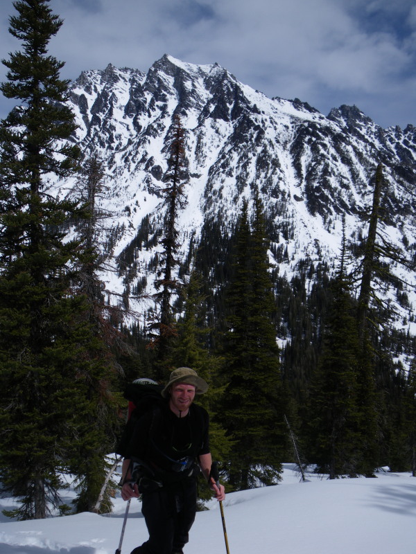
Will made the excellent suggestion of Stuart for the weekend. Ulrich's Couloir became the goal, subordinate to finding something fun to ski. Approached Saturday via Beverley Creek and skied nice corn to Turnpike Creek. After much debate about couloir entrances (Beckey's statement that the couloir systems are confusing is correct), we made our choice and climbed up to a moderately well protected campsite in the trees a little above 6k. Unconvinced of the state of the snowpack, and having seen the upper pitches in full sun at 9 am on the drive in, we opted for an early start, leaving the tent at 4:30 am.
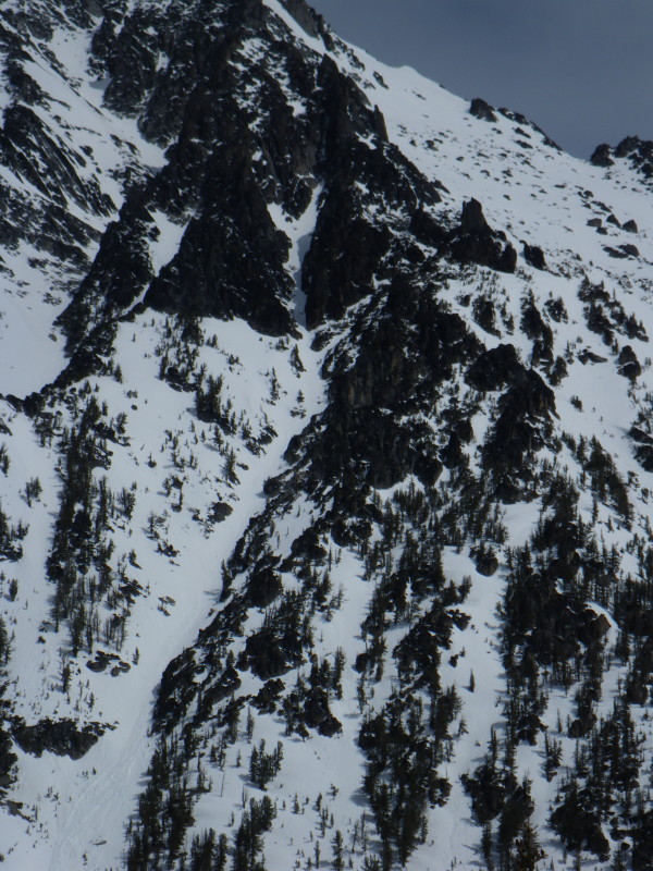
In the trees, the snow was still punchy/soft , but anything with exposure to open sky had frozen well enough to provide temporary passage and safety. Once above the avy fan, the avalanche raked bed surface was plenty easy to crampon. Our choices led us into an aesthetic couloir (the prettiest I've ever experienced - too gripped to photograph, but the memories will hopefully be with me for a long time.), fairly deeply inset, with steep firm climbing and beautiful views. Slopes were consistently 45ish degrees, with sizeable sections steeper than fifty. Sections of blue ice were beginning to show through, but avoidable at our whim. We climbed until the couloir ended in an impassable granite headwall, selecting its upper climber's left branch in a last desperate hope for a passage toward the summit. We chose a pair of little easily-expanded wind scoop formations for our transition on the steep headwall, the most committing transition either of us have done. Will gets extra points - it was his second descent on Dynafits.
The 8 am ski was mighty scratchy, but waiting for the noonish corn cycle in the sheltered groove would entailed a long wait on our little perches. Will, as usual, confidently turned down the gut, though he was confined to scratching to a halt after nearly every hop. My combination of new skis and lack of confidence on firm snow/avy chunks saw me make two turns in the top 1500' of the route, sidestepping, steep kick turns, and sideslipping were the orders of the morning. Will's a patient man.
At the exit of the defined gully system, we traversed west, hoping to see the entrance to Ulrich's that we'd missed, but were quickly impeded by terrain. Now on sun-softened snow, we made quick work of the descent to camp, ogled the views, and descended back to Ingalls Creek. Hoping to enliven the return to the pass, we climbed over point 6047's W ridge. Lively it was - we kicked off notable pinwheels on the north-facing ascent and cut wet slides on the SE facing descent, with ski penetration to the knee on my skinny skis. After a short game of let's-lose-one-another-in-the-woods, we ascended comparatively consolidated snow back to the Turnpike-Beverley pass.
The descent from there went surprisingly well - traversing somewhat above the valley floor gave us a flat/gliding descent all the way to Bean Creek. The Beverley Creek road was superb for lazy travel - point'em and glide all the way to the Teanaway. Teanaway road was similar, but flat. Met a friendly four coming back from their own tour as we de-skied for the patchy road; smiles suggested they'd had a good day too. Pass to car time was only about three hours.
Snow: too variable by elevation and aspect to describe completely. Above ~5k, there was increasing evidence of new snow atop the consolidating, occasionally isothermal, snowpack. Corn-'o-clock struck between 9 and 11 am for S/E facing snow. Goo-'o-clock followed not long after. We felt our timing was correct for the summit attempt; any attempt to ascend the Cascadian after our turnaround would have been far too late. Best snow was probably the W facing descent above Turnpike creek Saturday - soft corn. Worst was the E facing descent above Turnpike Sunday - deep wet goo.
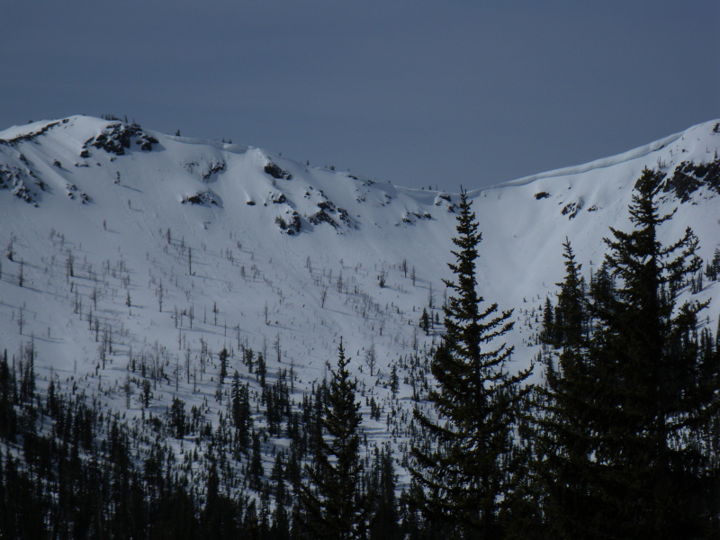
Logistics: The Teanaway road is melted out a little past the turnaround 4 mi from the Beverley campground. Patchy snow on the descent begins perhaps a mile downstream from the creek/river junction. Beverley Creek road will have a few minor snowbreaks by the end of Monday. A few slopes near Bean Creek are completely melted out, but everything else is snowy. As attached in the photo below, Longs Pass would probably involve cornice shenanigans in the near future. The dead horse is thoroughly decomposed, as far as we could see.
Photo note: we climbed and skied/sideslipped the left hand branch of the prominent Y-shaped snow inset in the black rock. It's probably visible from Longs Pass, but invisible from our approach.
Mighty fine trip - it had a little bit of everything.
In the trees, the snow was still punchy/soft , but anything with exposure to open sky had frozen well enough to provide temporary passage and safety. Once above the avy fan, the avalanche raked bed surface was plenty easy to crampon. Our choices led us into an aesthetic couloir (the prettiest I've ever experienced - too gripped to photograph, but the memories will hopefully be with me for a long time.), fairly deeply inset, with steep firm climbing and beautiful views. Slopes were consistently 45ish degrees, with sizeable sections steeper than fifty. Sections of blue ice were beginning to show through, but avoidable at our whim. We climbed until the couloir ended in an impassable granite headwall, selecting its upper climber's left branch in a last desperate hope for a passage toward the summit. We chose a pair of little easily-expanded wind scoop formations for our transition on the steep headwall, the most committing transition either of us have done. Will gets extra points - it was his second descent on Dynafits.
The 8 am ski was mighty scratchy, but waiting for the noonish corn cycle in the sheltered groove would entailed a long wait on our little perches. Will, as usual, confidently turned down the gut, though he was confined to scratching to a halt after nearly every hop. My combination of new skis and lack of confidence on firm snow/avy chunks saw me make two turns in the top 1500' of the route, sidestepping, steep kick turns, and sideslipping were the orders of the morning. Will's a patient man.
At the exit of the defined gully system, we traversed west, hoping to see the entrance to Ulrich's that we'd missed, but were quickly impeded by terrain. Now on sun-softened snow, we made quick work of the descent to camp, ogled the views, and descended back to Ingalls Creek. Hoping to enliven the return to the pass, we climbed over point 6047's W ridge. Lively it was - we kicked off notable pinwheels on the north-facing ascent and cut wet slides on the SE facing descent, with ski penetration to the knee on my skinny skis. After a short game of let's-lose-one-another-in-the-woods, we ascended comparatively consolidated snow back to the Turnpike-Beverley pass.
The descent from there went surprisingly well - traversing somewhat above the valley floor gave us a flat/gliding descent all the way to Bean Creek. The Beverley Creek road was superb for lazy travel - point'em and glide all the way to the Teanaway. Teanaway road was similar, but flat. Met a friendly four coming back from their own tour as we de-skied for the patchy road; smiles suggested they'd had a good day too. Pass to car time was only about three hours.
Snow: too variable by elevation and aspect to describe completely. Above ~5k, there was increasing evidence of new snow atop the consolidating, occasionally isothermal, snowpack. Corn-'o-clock struck between 9 and 11 am for S/E facing snow. Goo-'o-clock followed not long after. We felt our timing was correct for the summit attempt; any attempt to ascend the Cascadian after our turnaround would have been far too late. Best snow was probably the W facing descent above Turnpike creek Saturday - soft corn. Worst was the E facing descent above Turnpike Sunday - deep wet goo.
Logistics: The Teanaway road is melted out a little past the turnaround 4 mi from the Beverley campground. Patchy snow on the descent begins perhaps a mile downstream from the creek/river junction. Beverley Creek road will have a few minor snowbreaks by the end of Monday. A few slopes near Bean Creek are completely melted out, but everything else is snowy. As attached in the photo below, Longs Pass would probably involve cornice shenanigans in the near future. The dead horse is thoroughly decomposed, as far as we could see.
Photo note: we climbed and skied/sideslipped the left hand branch of the prominent Y-shaped snow inset in the black rock. It's probably visible from Longs Pass, but invisible from our approach.
Mighty fine trip - it had a little bit of everything.
The No-name Couloir strikes again. Be assured your choice of gullies was not unique. Do note the right sloping ramp just before the gully constricts. This easily leads one to the upper slopes of the Cascadian route. Great trip, thanks for the report.
author=glenn_b link=topic=13080.msg54472#msg54472 date=1240247414]
Be assured your choice of gullies was not unique.
We were pretty sure it wasn't - it's such an obvious way to go (and fun at that!).
author=glenn_b] Do note the right sloping ramp just before gully constricts. This easily leads one to the upper slopes of the Cascadian route.
We thought it might, but weren't sure enough to give it a go until we could see it again from afar. The walled-out couloir might be fun to combine with the Cascadian, as you could ski from the false summit, use that ramp to get below the Y, climb it, and ski from there to the creek, all following the sun....
Thanks! :)!
Edit: I just looked at aerial photos - that ramp looks clean all the way. The Ulrich's exit is mighty small for such a sizeable drainage. Thanks again!
Most excellent, nice trip!
Reply to this TR
Please login first: