- Posts: 88
- Thank you received: 0
Avy Hazard and Decision Making (from Cement Basin post)
- GerryH
-
 Topic Author
- User
-

Less
More
14 years 3 months ago - 14 years 3 months ago #97648
by GerryH
Avy Hazard and Decision Making (from Cement Basin post) was created by GerryH
EDIT by Marcus -- this is a split off topic from the Cement Basin post
here
.
**************
Nice images, nice day, nice terrain, nice snow......but am I missing something here? Leeward slope, over a foot of wind transported snow, rotten, breakable crust beneath the wind transported, and short slopes yo yo'd in what appears to be a 25 to 35 degree range. And then a pit dug (before or after making the 'to ski it' decision?), at 35 degrees, with a CT 7, maybe Q1 quality. With some sun, perhaps some warming, snow settling, soft slab forming if not already a bit wind compacted? Safe travel practice employed? - hard to tell from picture angles.
The point is, are my friend (who alerted me to the post) and I the only two of the 670 readers of this post, who up to this time have read this post and wondered a bit about the decision making process leading to this story? No one else has posted wondering. I hope not. It is probably perfectly explainable, I just don't have all the info. Just thinking. Gerry
Last edit: 14 years 3 months ago by Marcus.
Please Log in or Create an account to join the conversation.
- Pete A
-
- User
-
Less
More
- Posts: 431
- Thank you received: 0
14 years 3 months ago #97651
by Pete A
Replied by Pete A on topic Re: Avy Hazard and Decision Making (from Cement Basin post)
Hi Gerry,
I'm happy to provide some additional info. I probably should've provided some more details from the get-go so that folks would have a better idea of what we were skiing and our decision process...
I did the tap test on a column after our first lap. On our first lap we stuck to very mellow terrain...most of the terrain was less than 25 degrees... the only real exception being that I was actually looking for something steeper so I could do some kind of test, and mid-way through our first lap, when the other skiers were in a safe spot, I did ski cut and stomp a couple very short 35 degree rolls to see if I could get the new snow to move...I didn't get any whoomps, shooting cracks, just a little sluffing.
Before we started our first run, and on our skin up through Bullion, we poked around and looked at the snowpack, and I dug a few hasty pits but because we weren't near a steep pitch, any kind of tap test info would've been skewed (at least thats been my experience in the past trying to assign a tap failure number to a slope that has a rather shallow angle). We figured given what we'd seen from the snowpack on the way up, and what we saw at the top of our first run, it was perfectly reasonably to ski something way less than prime angle and take a closer look at the snowpack when we found something steeper.
I had to veer out of our skin track which was set on a fairly mellow pitch to find a short 35 degree roll to dig the pit on so that we could get a more accurate read on how the crust and new snow was behaving. Given what we found, we continued lapping the mellower pitches we had already skied and deliberately avoided moving into some lines that had a continuous steep pitch.
As for the sun....it was dumb luck that we started our first lap and I snapped some pics right when the sun came out...my guess is that we had sunshine for about 20 minutes before it was overcast the rest of the day. The sun didn't make any obvious changes to the snow we were skiing (it certainly might've effected it some, but not that we could tell)...the snow was still rather light on our second lap when the sky was overcast.
Though the sun was certainly on my mind, and if we had been on a direct south exposure (we were on an east facing slope), its certainly possible that the brief shot of sun we got would've been enough to cause the new snow to become more cohesive and have some slabby instead of sluffy behavior.
Hopefully that helps clear things up. If you think we were behaving recklessly, I'm always welcome to hear constructive criticism.
Please Log in or Create an account to join the conversation.
- Eli3
-
- User
-
Less
More
- Posts: 69
- Thank you received: 0
14 years 3 months ago #97654
by Eli3
Replied by Eli3 on topic Re: Avy Hazard and Decision Making (from Cement Basin post)
I think biggest surprise for me for the day was seeing so many tracks down the hourglass - hard crust with 8-10" of wind effected snow on a 35-40 degree lee slope that has a history of avy accidents. With such undulating terrain into the narrow portion of the run, we assumed a pit to be pretty worthless since so many aspects are touched on the way down. We did the mellower slope to skiers left and did not see any cracking, but from the poor bonding we saw on the south side of east peak skinning up (skinning above the skin track caused 8" slab to brake loose in multiple areas), we avoided the hourglass.... I guess things were bonded better than we thought!
I was very surprised at the moderate danger predicted by NWAC too - there was lots of wind transport & loading after it stopped raining.
I was very surprised at the moderate danger predicted by NWAC too - there was lots of wind transport & loading after it stopped raining.
Please Log in or Create an account to join the conversation.
- GerryH
-
Topic Author
- User
-
Less
More
- Posts: 88
- Thank you received: 0
14 years 3 months ago #97657
by GerryH
Replied by GerryH on topic Re: Avy Hazard and Decision Making (from Cement Basin post)
Thanks so much, Pete, and to your crew. I hope everyone can revisit both your original and your recent update post, because together they paint the kind of picture we all want to emulate.
Maintaining good group communications, having your antenna up and being observant your entire trip, maintaining individual and group consciousness, having a plan, sticking to it while choosing the right terrain, safely testing the snowpack, all are so critical to staying safe while still getting the goods.
I don't hold myself up as an expert to judge others, but have and am investing a lot of time in avalanche education - as both a student and instructor. And am sometimes outspoken in my opinions. I think those of us fortunate enough to have gained a lot of avalanche experience, and education, have a responsibility to those at the beginning of their backcountry experiences, to share our knowledge - as others did for us. And it was in that spirit that I offered up my comments. Sometimes taking a few extra sentences of explanation can dispel that ski film bravado of just jumping into it and letting it rip, when in fact those ski stars have their heli hovering just out of camera sight and a crew of avy rescue professionals & first aiders on standbye - just in case. So I'd say your turns were very well earned. Thanks! Gerry
Please Log in or Create an account to join the conversation.
- Amar Andalkar
-
- User
-
Less
More
- Posts: 635
- Thank you received: 0
14 years 3 months ago - 14 years 3 months ago #97661
by Amar Andalkar
Replied by Amar Andalkar on topic Re: Avy Hazard and Decision Making (from Cement Basin post)
Well, if we're going to analyze the avy hazard and decision-making here, might as well link to the available forecasts and data for reference:
Danger rose for all zones near and west of the Cascade crest:
http://www.nwac.us/dangerrose/preview/2043/
NWAC avy forecast from Sunday, Dec 25, the latest available before this trip: www.nwac.us/archive/sabsea_2011-12-25-1115.html
The updated avy forecast on Dec 26 did not increase the hazard rating either, the key statement perhaps being that "no avalanches were reported upon control work at Stevens Pass or Crystal Mountain Monday morning": www.nwac.us/archive/sabsea_2011-12-26-1236.html
Weather summary: On Dec 25, the Crystal Mountain area had unexpectedly received the most snowfall of any location in the Cascades, with 9" new reported by the ski area and 7" new showing on the Green Valley NWAC telemetry -- no other measurement site had more than 5-6" new that day, with most closer to 2" new. The new snow at Crystal had fallen from 11am to 8pm during moderately strong W and NW winds, see telemetry below. Field reports verified that 9" new snow amount on flat protected slopes, such as in Bullion Basin.
[hr]
I skied several runs on the same slopes and other neighboring slopes with another group that day, and thought that the avalanche danger was Low-to-Moderate at most. It was certainly not Considerable (meaning "Natural avalanches possible; human-triggered avalanches likely.") in any location or aspect that we skinned or skied. Natural avalanches did not appear to be possible, and human-triggered avalanches appeared to be very unlikely.
I think the reason for the relatively low-ish hazard was that the deeper areas of new snow (wherever the wind had transported the snow) felt generally cohesionless, not slabby, and the only slightly slabby areas were the wind-hammered slopes which had much less new snow atop the crust. There's not much avy hazard when the so-called slabs are 2-4" deep maximum, and have no fracture energy or propagation whatsoever. Not sure about where someone saw those 8" slabs beside the skin track up the SW side of East Peak -- we skinned up the same skin track and saw only 2-4" deep mini-slabs (like 1 ski-length in size) beside the skin track in a couple spots, even those only on the iciest sections of smooth old sun crust.
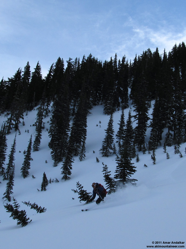
We started the day by breaking trail into Bullion Basin and up Point 6479 (Bullion Peak ?) via its N face and NW ridge. Conditions felt totally stable underfoot while putting in the skin track, even on every steep roll on the open face and ridge, nothing was slabby or sliding. We skied down the N face (an obvious big avy slope) in very stable conditions. Slight slabbiness right near the summit where the new snow was wind-hammered and thin (0-4"), but that was just a breakable windcrust that was not sliding anywhere. Then again cohesionless and not slabby or wind-affected at all just a bit lower as soon as the snow got deep enough (say 6-8") to be fun skiing.
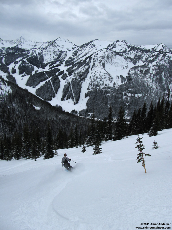
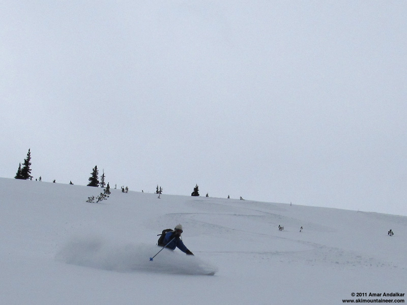
When the sun came out at the end of that run (around 11:30am), we decided to head up the SW side of East Peak just to get out of the very cold shade and enjoy the sunshine. We were just planning to ski the SW side, but decided to ski the steeper NE and ENE aspects (30-40 degrees) from the summit of East Peak only after seeing a handful of ski tracks having already descended safely down this aspect (another obvious big avy slope). We found excellent stable powder with absolutely nothing sliding or moving, and quite deep, generally 9-12" deep all the way down to the flats at 5900 ft. Nice enough to ski 2 runs down there. We dug no pits.
Regarding sun and warming: at this time of year, the sun can really only affect steep S-facing slopes due to its very low angle and limited range of azimuth. All other aspects and slope angles get very minimal insolation even on a totally sunny day -- they are almost immune. Despite the sun being out for a while this day (full sun for maybe 20-30 minutes, partial filtered sun for maybe 2-3 hours), even the steep S and SW facing slope from the summit of East Peak showed almost no signs of sun effect. When we finally skied back down at sunset, there was no breakable sun crust, just very nice stable powder once we dropped below the thin wind-hammered areas up high. So other slopes (everything not steep S-facing) obviously had zero sun effect this day. There was very little warming during the day, and the next incoming storm did not arrive until late afternoon, with very light snowfall beginning near 4pm (too light to show up on telemetry).
Some photos of our day:
N aspect:
SW aspect:
ENE aspect:
[size=small][tt]
Northwest Weather and Avalanche Center Northwest Weather and Avalanche Center
Crystal Mountain Ski Area, Washington Green Valley, Crystal Mountain Ski Area
MM/DD Hour Temp Temp RH RH Wind Wind Wind Wind Hour Total 24 Hr Total MM/DD Hour Temp 24 Hr Total
PST F F % % Min Avg Max Dir Prec. Prec. Snow Snow PST F Snow Snow
6830' 4570' 6830' 4570' 6830' 6830' 6830' 6830' 4570' 4570' 4570' 4570' 6230' 6230' 6230'
12 25 500 35 43 44 47 10 24 44 200 0 0 0 32 12 25 500 35 0 43
12 25 600 34 44 50 41 14 28 56 228 0 0 0 32 12 25 600 34 0 43
12 25 700 32 41 53 46 13 30 53 191 0 0 0 33 12 25 700 32 0 42
12 25 800 31 42 55 41 13 34 59 190 0 0 0 33 12 25 800 32 0 42
12 25 900 30 42 52 39 13 35 63 210 0 0 0 33 12 25 900 31 0 42
12 25 1000 29 41 54 39 15 34 65 212 0 0 0 33 12 25 1000 29 0 42
12 25 1100 24 33 99 95 11 29 64 206 .03 .03 0 31 12 25 1100 24 0 37
12 25 1200 24 32 99 96 13 31 55 234 .08 .11 1 33 12 25 1200 24 0 43
12 25 1300 24 32 98 97 8 21 44 287 .05 .16 47 33 12 25 1300 23 1 43
12 25 1400 24 31 99 97 4 14 30 272 .03 .19 47 33 12 25 1400 23 1 43
12 25 1500 22 30 99 99 7 21 52 215 .11 .3 3 35 12 25 1500 22 3 45
12 25 1600 21 29 98 99 11 29 53 263 .07 .37 47 238 12 25 1600 20 4 44
12 25 1700 20 28 98 99 10 28 56 274 .09 .46 4 37 12 25 1700 19 5 47
12 25 1800 18 26 97 99 11 28 50 190 .09 .55 5 39 12 25 1800 17 7 50
12 25 1900 18 26 97 98 11 26 48 262 .04 .59 5 38 12 25 1900 16 7 49
12 25 2000 17 26 97 98 7 22 42 268 .02 .61 5 38 12 25 2000 16 7 48
12 25 2100 16 25 96 97 13 21 30 291 0 .61 5 38 12 25 2100 15 8 51
12 25 2200 15 23 96 97 7 16 25 308 0 .61 5 38 12 25 2200 14 7 51
12 25 2300 16 22 96 97 8 17 28 278 0 .61 5 37 12 25 2300 13 7 51
12 26 0 16 22 96 96 5 15 26 276 0 .61 5 37 12 26 0 13 7 50
12 26 100 14 21 96 97 6 18 27 273 0 .61 5 37 12 26 100 12 7 50
12 26 200 15 21 96 96 10 21 30 289 0 .61 5 37 12 26 200 12 7 51
12 26 300 15 20 96 95 8 14 23 270 0 .61 5 38 12 26 300 12 7 50
12 26 400 15 20 96 96 6 11 16 164 0 .61 5 38 12 26 400 12 7 49
12 26 500 15 21 97 97 3 9 20 242 0 0 5 38 12 26 500 14 7 50
12 26 600 16 23 97 97 4 11 19 203 0 0 5 38 12 26 600 15 7 50
12 26 700 18 24 94 97 4 9 14 206 0 0 5 38 12 26 700 15 7 50
12 26 800 19 25 96 97 1 7 14 142 0 0 0 38 12 26 800 18 7 50
12 26 900 20 25 95 96 4 12 22 151 0 0 0 38 12 26 900 17 7 50
12 26 1000 20 25 90 94 7 21 37 189 0 0 0 38 12 26 1000 18 7 50
12 26 1100 22 27 72 90 18 30 42 184 0 0 0 38 12 26 1100 20 7 49
12 26 1200 22 27 72 94 6 18 40 150 0 0 0 38 12 26 1200 22 7 49
12 26 1300 21 29 62 87 3 15 33 194 0 0 0 38 12 26 1300 22 7 48
12 26 1400 21 28 68 86 3 18 37 204 0 0 0 37 12 26 1400 21 7 49
12 26 1500 21 28 85 94 2 8 22 164 0 0 0 37 12 26 1500 19 6 49
12 26 1600 20 27 90 95 0 4 12 194 0 0 0 38 12 26 1600 18 6 49
12 26 1700 18 26 95 91 4 11 20 198 0 0 0 38 12 26 1700 17 6 49
12 26 1800 18 26 95 93 6 19 37 207 0 0 0 38 12 26 1800 19 6 49
[/tt][/size]
Danger rose for all zones near and west of the Cascade crest:
http://www.nwac.us/dangerrose/preview/2043/
NWAC avy forecast from Sunday, Dec 25, the latest available before this trip: www.nwac.us/archive/sabsea_2011-12-25-1115.html
The updated avy forecast on Dec 26 did not increase the hazard rating either, the key statement perhaps being that "no avalanches were reported upon control work at Stevens Pass or Crystal Mountain Monday morning": www.nwac.us/archive/sabsea_2011-12-26-1236.html
Weather summary: On Dec 25, the Crystal Mountain area had unexpectedly received the most snowfall of any location in the Cascades, with 9" new reported by the ski area and 7" new showing on the Green Valley NWAC telemetry -- no other measurement site had more than 5-6" new that day, with most closer to 2" new. The new snow at Crystal had fallen from 11am to 8pm during moderately strong W and NW winds, see telemetry below. Field reports verified that 9" new snow amount on flat protected slopes, such as in Bullion Basin.
[hr]
I skied several runs on the same slopes and other neighboring slopes with another group that day, and thought that the avalanche danger was Low-to-Moderate at most. It was certainly not Considerable (meaning "Natural avalanches possible; human-triggered avalanches likely.") in any location or aspect that we skinned or skied. Natural avalanches did not appear to be possible, and human-triggered avalanches appeared to be very unlikely.
I think the reason for the relatively low-ish hazard was that the deeper areas of new snow (wherever the wind had transported the snow) felt generally cohesionless, not slabby, and the only slightly slabby areas were the wind-hammered slopes which had much less new snow atop the crust. There's not much avy hazard when the so-called slabs are 2-4" deep maximum, and have no fracture energy or propagation whatsoever. Not sure about where someone saw those 8" slabs beside the skin track up the SW side of East Peak -- we skinned up the same skin track and saw only 2-4" deep mini-slabs (like 1 ski-length in size) beside the skin track in a couple spots, even those only on the iciest sections of smooth old sun crust.
We started the day by breaking trail into Bullion Basin and up Point 6479 (Bullion Peak ?) via its N face and NW ridge. Conditions felt totally stable underfoot while putting in the skin track, even on every steep roll on the open face and ridge, nothing was slabby or sliding. We skied down the N face (an obvious big avy slope) in very stable conditions. Slight slabbiness right near the summit where the new snow was wind-hammered and thin (0-4"), but that was just a breakable windcrust that was not sliding anywhere. Then again cohesionless and not slabby or wind-affected at all just a bit lower as soon as the snow got deep enough (say 6-8") to be fun skiing.
When the sun came out at the end of that run (around 11:30am), we decided to head up the SW side of East Peak just to get out of the very cold shade and enjoy the sunshine. We were just planning to ski the SW side, but decided to ski the steeper NE and ENE aspects (30-40 degrees) from the summit of East Peak only after seeing a handful of ski tracks having already descended safely down this aspect (another obvious big avy slope). We found excellent stable powder with absolutely nothing sliding or moving, and quite deep, generally 9-12" deep all the way down to the flats at 5900 ft. Nice enough to ski 2 runs down there. We dug no pits.
Regarding sun and warming: at this time of year, the sun can really only affect steep S-facing slopes due to its very low angle and limited range of azimuth. All other aspects and slope angles get very minimal insolation even on a totally sunny day -- they are almost immune. Despite the sun being out for a while this day (full sun for maybe 20-30 minutes, partial filtered sun for maybe 2-3 hours), even the steep S and SW facing slope from the summit of East Peak showed almost no signs of sun effect. When we finally skied back down at sunset, there was no breakable sun crust, just very nice stable powder once we dropped below the thin wind-hammered areas up high. So other slopes (everything not steep S-facing) obviously had zero sun effect this day. There was very little warming during the day, and the next incoming storm did not arrive until late afternoon, with very light snowfall beginning near 4pm (too light to show up on telemetry).
Some photos of our day:
N aspect:
SW aspect:
ENE aspect:
[size=small][tt]
Northwest Weather and Avalanche Center Northwest Weather and Avalanche Center
Crystal Mountain Ski Area, Washington Green Valley, Crystal Mountain Ski Area
MM/DD Hour Temp Temp RH RH Wind Wind Wind Wind Hour Total 24 Hr Total MM/DD Hour Temp 24 Hr Total
PST F F % % Min Avg Max Dir Prec. Prec. Snow Snow PST F Snow Snow
6830' 4570' 6830' 4570' 6830' 6830' 6830' 6830' 4570' 4570' 4570' 4570' 6230' 6230' 6230'
12 25 500 35 43 44 47 10 24 44 200 0 0 0 32 12 25 500 35 0 43
12 25 600 34 44 50 41 14 28 56 228 0 0 0 32 12 25 600 34 0 43
12 25 700 32 41 53 46 13 30 53 191 0 0 0 33 12 25 700 32 0 42
12 25 800 31 42 55 41 13 34 59 190 0 0 0 33 12 25 800 32 0 42
12 25 900 30 42 52 39 13 35 63 210 0 0 0 33 12 25 900 31 0 42
12 25 1000 29 41 54 39 15 34 65 212 0 0 0 33 12 25 1000 29 0 42
12 25 1100 24 33 99 95 11 29 64 206 .03 .03 0 31 12 25 1100 24 0 37
12 25 1200 24 32 99 96 13 31 55 234 .08 .11 1 33 12 25 1200 24 0 43
12 25 1300 24 32 98 97 8 21 44 287 .05 .16 47 33 12 25 1300 23 1 43
12 25 1400 24 31 99 97 4 14 30 272 .03 .19 47 33 12 25 1400 23 1 43
12 25 1500 22 30 99 99 7 21 52 215 .11 .3 3 35 12 25 1500 22 3 45
12 25 1600 21 29 98 99 11 29 53 263 .07 .37 47 238 12 25 1600 20 4 44
12 25 1700 20 28 98 99 10 28 56 274 .09 .46 4 37 12 25 1700 19 5 47
12 25 1800 18 26 97 99 11 28 50 190 .09 .55 5 39 12 25 1800 17 7 50
12 25 1900 18 26 97 98 11 26 48 262 .04 .59 5 38 12 25 1900 16 7 49
12 25 2000 17 26 97 98 7 22 42 268 .02 .61 5 38 12 25 2000 16 7 48
12 25 2100 16 25 96 97 13 21 30 291 0 .61 5 38 12 25 2100 15 8 51
12 25 2200 15 23 96 97 7 16 25 308 0 .61 5 38 12 25 2200 14 7 51
12 25 2300 16 22 96 97 8 17 28 278 0 .61 5 37 12 25 2300 13 7 51
12 26 0 16 22 96 96 5 15 26 276 0 .61 5 37 12 26 0 13 7 50
12 26 100 14 21 96 97 6 18 27 273 0 .61 5 37 12 26 100 12 7 50
12 26 200 15 21 96 96 10 21 30 289 0 .61 5 37 12 26 200 12 7 51
12 26 300 15 20 96 95 8 14 23 270 0 .61 5 38 12 26 300 12 7 50
12 26 400 15 20 96 96 6 11 16 164 0 .61 5 38 12 26 400 12 7 49
12 26 500 15 21 97 97 3 9 20 242 0 0 5 38 12 26 500 14 7 50
12 26 600 16 23 97 97 4 11 19 203 0 0 5 38 12 26 600 15 7 50
12 26 700 18 24 94 97 4 9 14 206 0 0 5 38 12 26 700 15 7 50
12 26 800 19 25 96 97 1 7 14 142 0 0 0 38 12 26 800 18 7 50
12 26 900 20 25 95 96 4 12 22 151 0 0 0 38 12 26 900 17 7 50
12 26 1000 20 25 90 94 7 21 37 189 0 0 0 38 12 26 1000 18 7 50
12 26 1100 22 27 72 90 18 30 42 184 0 0 0 38 12 26 1100 20 7 49
12 26 1200 22 27 72 94 6 18 40 150 0 0 0 38 12 26 1200 22 7 49
12 26 1300 21 29 62 87 3 15 33 194 0 0 0 38 12 26 1300 22 7 48
12 26 1400 21 28 68 86 3 18 37 204 0 0 0 37 12 26 1400 21 7 49
12 26 1500 21 28 85 94 2 8 22 164 0 0 0 37 12 26 1500 19 6 49
12 26 1600 20 27 90 95 0 4 12 194 0 0 0 38 12 26 1600 18 6 49
12 26 1700 18 26 95 91 4 11 20 198 0 0 0 38 12 26 1700 17 6 49
12 26 1800 18 26 95 93 6 19 37 207 0 0 0 38 12 26 1800 19 6 49
[/tt][/size]
Last edit: 14 years 3 months ago by Marcus.
Please Log in or Create an account to join the conversation.
- Zap
-
- User
-
Less
More
- Posts: 1212
- Thank you received: 3
14 years 3 months ago #97664
by Zap
Replied by Zap on topic Re: Avy Hazard and Decision Making (from Cement Basin post)
Amar, I love the last photo with a great "face shot" . ")
Please Log in or Create an account to join the conversation.