- Posts: 1460
- Thank you received: 16
HOW'D THAT HAPPEN??
- Lowell_Skoog
-

- User
-

Less
More
12 years 10 months ago #122022
by Lowell_Skoog
That's quite a sentence!
But it sounds plausible to me.
The thing that still has me puzzled is the very dark (sooty almost) crown wall at the top of the avalanche.
Were did that dirt come from? Did it collect on the crown wall after the slide released (from clouds of sooty steam perhaps)? Or did it collect before the slide released (perhaps as steam escaped through an initial glide crack)?
Why is the upper crown wall dirty, while the flanking walls are clean?
Replied by Lowell_Skoog on topic Re: HOW'D THAT HAPPEN??
well, .. those cracks have been there a while, eh? including the ones whose remnants are barely seen along the left edge of the slide, in the first magnified pic, and all in a decreasing radius from what would be the epicenter of the slumping snow, which gave way at one point as a wet slide due to localized subterranean heating, as evidenced by the small central and completely snow-free spot on the bed, pulling the snow from above, yet below the upper crack, with it as it moved a very short distance down slope, encountering firmer conditions and thereby jumping back onto the surface, leaving that hump at the top of the debris pile, and the rest sloughing according to fall line, moving the top couple of inches of snow - slush, really - along the perimeter, the same as a played-out wave will move the edge of seafoam inward on that wide, flat beach, demonstrating clearly the near liquid nature of a portion of that snowfield, set free by that single warm locus.
That's quite a sentence!
But it sounds plausible to me.
The thing that still has me puzzled is the very dark (sooty almost) crown wall at the top of the avalanche.
Were did that dirt come from? Did it collect on the crown wall after the slide released (from clouds of sooty steam perhaps)? Or did it collect before the slide released (perhaps as steam escaped through an initial glide crack)?
Why is the upper crown wall dirty, while the flanking walls are clean?
Please Log in or Create an account to join the conversation.
- T. Eastman
-

- User
-
Less
More
- Posts: 288
- Thank you received: 0
12 years 10 months ago #122026
by T. Eastman
Replied by T. Eastman on topic Re: HOW'D THAT HAPPEN??
It was the work of Orcs!
Please Log in or Create an account to join the conversation.
- snoslut
-
- User
-
Less
More
- Posts: 115
- Thank you received: 0
12 years 10 months ago #122038
by snoslut
Replied by snoslut on topic Re: HOW'D THAT HAPPEN??
Jarvis Jelly, that's how.
Please Log in or Create an account to join the conversation.
- TN
-
- User
-
Less
More
- Posts: 50
- Thank you received: 0
12 years 10 months ago #122043
by TN
Replied by TN on topic Re: HOW'D THAT HAPPEN??
Seems to me that the guesses are right on, especially with that bare ground just above. Glide crack/dirty flow etc. That's a lot of weight to pop over the stauchwall, the snow below must be stuck pretty well. That spot should melt out quickly. Hopefully, someone will go right to it later and get pics. Looks like a rather smooth spot, is the rest of the area rougher?
Please Log in or Create an account to join the conversation.
- aaron_wright
-
- User
-
Less
More
- Posts: 429
- Thank you received: 0
12 years 10 months ago #122050
by aaron_wright
Replied by aaron_wright on topic Re: HOW'D THAT HAPPEN??
The end is near, isn't that like a miniature lahar? Get ready Westsiders.
Please Log in or Create an account to join the conversation.
- Amar Andalkar
-
- User
-
Less
More
- Posts: 635
- Thank you received: 0
12 years 10 months ago #122055
by Amar Andalkar
Replied by Amar Andalkar on topic Re: HOW'D THAT HAPPEN??
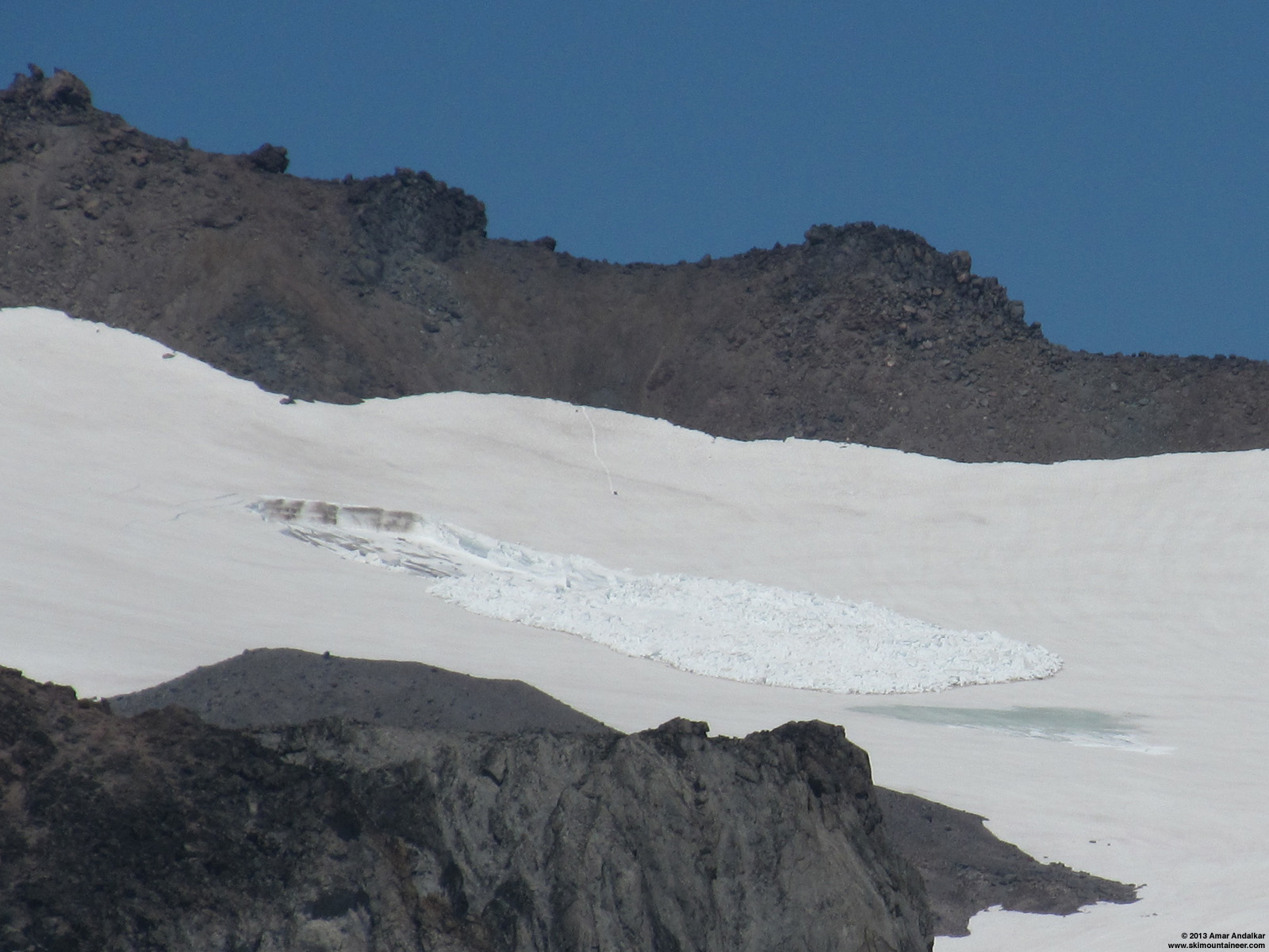
Interesting discussion and guesses here as to the cause of one of the most unusual avalanches I've ever seen. But the key point which seems to be missing in the posts above is that this avalanche occurred out in the middle of the Whitman Glacier! Therefore, the bed surface is entirely glacial ice, which must remain at a constant temperature of 0° C throughout the spring and summer. Thus there is no possibility of (direct) heating of the snowpack by steam vents or other geothermal sources. Meltwater from some source, flowing under the snow (perhaps temporarily pooling atop the glacial ice?) and lubricating the icy bed surface, is the most likely cause.
Some background info: I had skinned up and skied down just a few yards west of the location of this avalanche on June 22 on the way to Little Tahoma ( see TR ), and at that time there was no evidence of anything unusual at all on that part of the Whitman Glacier. The avalanche occurred sometime between the afternoon of Sunday, June 30 (when my photos from Paradise Glacier showed no evidence of it) and July 3, when I took the photos below:

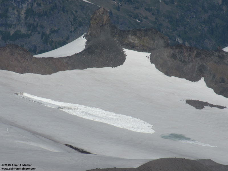
[size=small]Telephoto view looking NE across from about 7400 ft on Paradise Glacier. (click for double-size version)[/size]
[size=small]Telephoto view looking due east and down from Muir Rock, Point 10188. (click for double-size version)[/size]
These photos clearly show an area where meltwater has reached the surface of the snowpack some distance below the terminus of the avalanche debris. For whatever reason, they also appear to show a much less dirty crown wall than Ron's photos. Note that Ron's photos above were taken on July 7 (right?), 4 days after these.
The period from June 30 to July 3 was the hottest of 2013 thus far in Washington, with a huge ridge of high pressure building from the desert Southwest towards the Pacific Northwest. Daily high temperatures at SeaTac Airport reached 93 °F on June 30 (the same day that Death Valley set an all-time June record high for the US of 129 °F), decreasing to 89 °F on July 1, 83 °F on July 2, and 79 °F on July 3. The freezing level at Mount Rainier was 14500 ft on June 30, increasing to 15500 ft on July 1 and 16000 ft on July 2, maxing out at 16500 ft overnight into July 3 (those are about the highest freezing levels which occur in most years on Rainier, only very rarely and barely does it exceed those values). Certainly that was ideal weather for generating a large amount of meltwater at 8000 ft on and within the Whitman Glacier.
I was shocked and intrigued when I first spotted this avalanche on July 3 looking across from Paradise Glacier, and knew that I needed to make a trip out there to visit the site as soon as possible. I finally did so last Sunday:
July 14, 2013, Mt Rainier, Fryingpan Glacier to Whitman Glacier: Investigating an Unusual Summertime Glacier Avalanche
(Full report with many panoramic photos of the avalanche and its blue-ice bed surface, along with measurements of its size.)
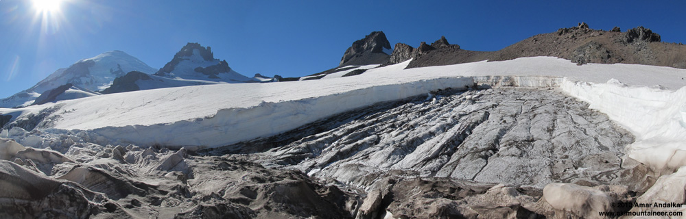
[size=small]Three-shot panorama from the southeast corner of the avalanche bed surface. (click for double-size version)[/size]
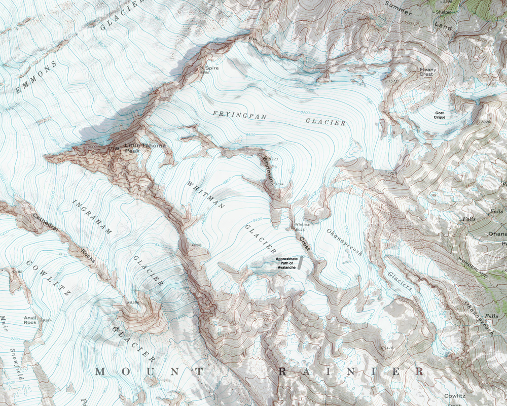
[size=small]Map of the avalanche site on Whitman Glacier. (click for double-size version)[/size]
[size=small](Topo + satellite overlay map from CalTopo )[/size]
Some background info: I had skinned up and skied down just a few yards west of the location of this avalanche on June 22 on the way to Little Tahoma ( see TR ), and at that time there was no evidence of anything unusual at all on that part of the Whitman Glacier. The avalanche occurred sometime between the afternoon of Sunday, June 30 (when my photos from Paradise Glacier showed no evidence of it) and July 3, when I took the photos below:
[size=small]Telephoto view looking NE across from about 7400 ft on Paradise Glacier. (click for double-size version)[/size]

[size=small]Telephoto view looking due east and down from Muir Rock, Point 10188. (click for double-size version)[/size]
These photos clearly show an area where meltwater has reached the surface of the snowpack some distance below the terminus of the avalanche debris. For whatever reason, they also appear to show a much less dirty crown wall than Ron's photos. Note that Ron's photos above were taken on July 7 (right?), 4 days after these.
The period from June 30 to July 3 was the hottest of 2013 thus far in Washington, with a huge ridge of high pressure building from the desert Southwest towards the Pacific Northwest. Daily high temperatures at SeaTac Airport reached 93 °F on June 30 (the same day that Death Valley set an all-time June record high for the US of 129 °F), decreasing to 89 °F on July 1, 83 °F on July 2, and 79 °F on July 3. The freezing level at Mount Rainier was 14500 ft on June 30, increasing to 15500 ft on July 1 and 16000 ft on July 2, maxing out at 16500 ft overnight into July 3 (those are about the highest freezing levels which occur in most years on Rainier, only very rarely and barely does it exceed those values). Certainly that was ideal weather for generating a large amount of meltwater at 8000 ft on and within the Whitman Glacier.
I was shocked and intrigued when I first spotted this avalanche on July 3 looking across from Paradise Glacier, and knew that I needed to make a trip out there to visit the site as soon as possible. I finally did so last Sunday:
July 14, 2013, Mt Rainier, Fryingpan Glacier to Whitman Glacier: Investigating an Unusual Summertime Glacier Avalanche
(Full report with many panoramic photos of the avalanche and its blue-ice bed surface, along with measurements of its size.)

[size=small]Three-shot panorama from the southeast corner of the avalanche bed surface. (click for double-size version)[/size]

[size=small]Map of the avalanche site on Whitman Glacier. (click for double-size version)[/size]
[size=small](Topo + satellite overlay map from CalTopo )[/size]
Please Log in or Create an account to join the conversation.