- Posts: 635
- Thank you received: 0
Baker snowdepth up from 20% to 100% 09-13Dec2018!
- Amar Andalkar
-
 Topic Author
- User
-

Less
More
7 years 7 months ago #232110
by Amar Andalkar
Baker snowdepth up from 20% to 100% 09-13Dec2018! was created by Amar Andalkar
Snowdepth at Mount Baker Ski Area reaches 100% of normal on 13Dec2018, was 20% of normal only 4 days ago!!
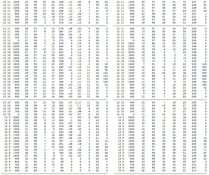
Following 25" of new snow since noon yesterday, the snowdepth at the 4200 ft Mount Baker Ski Area site hit 67" just after noon today Thursday, December 13. This is over 100% of normal depth for this date, as the December 15 normal is 67" at this site according to the NWAC Climatological Snowdepth data. Before the current storm cycle began on December 9, the snowdepth was only 13" at this site, only 20% of normal for that date! Just a very remarkable change in snowpack in such a short period, even for one of the snowiest measurement sites in the entire world. Total snowfall at Baker Ski Area over the 4-day period has been over 5 ft, with precip of over 7".
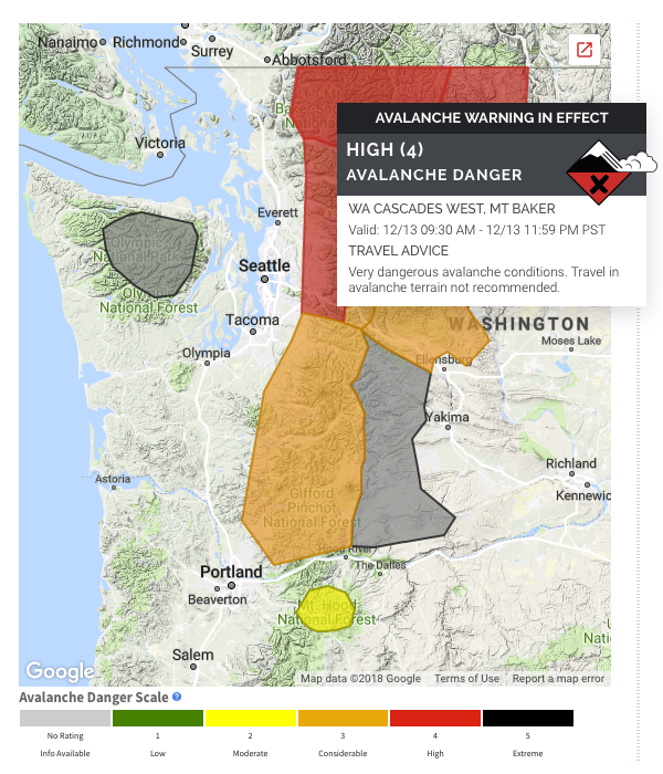
Unfortunately the new snowfall severely impacted operations at the ski area, which opened for the season only the day before on December 12, but was unable to open anything December 13 until noon, and even then only 2 lifts. From their website at noon, "Mt. Baker got absolutely hammered with an extreme amount of new snow and stormy, windy conditions last night. As we got out on the mountain this morning to prepare for opening we discovered that in some places the new snow drifted as deep as 4-5 feet. The avalanche danger is extreme and we are still doing avalanche control work. Chairs 5 & 7 are open, but the rest of the mountain will remain closed today as we continue to do avalanche control work." NWAC also posted their first Avalanche Warning of the season this morning, updating the Northwest Cascades zone which includes Mount Baker at 9:30am to "High" avalanche danger at all elevations.
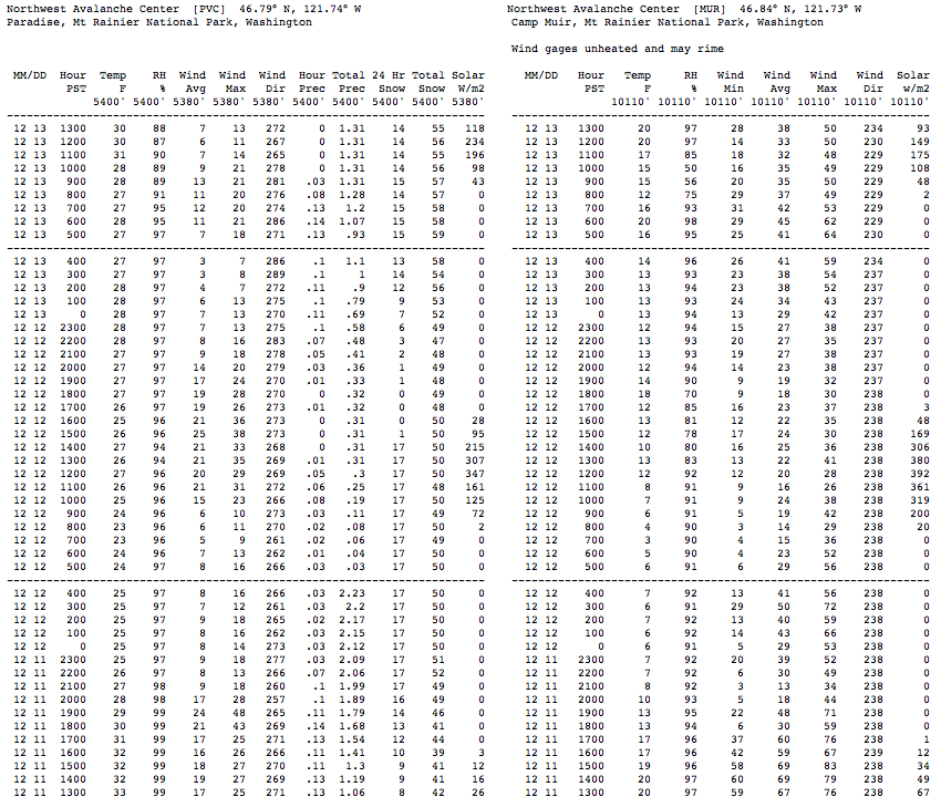
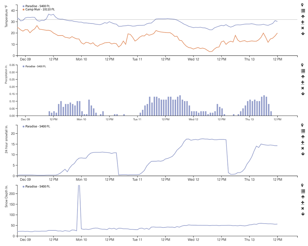
Other sites in the WA Cascades have also gotten heavy snowfall as forecast over these 4 days, although nothing close to Baker's amounts. The snowdepth at 5400 ft Paradise on Mount Rainier reached 59" this morning after 15" new (before settling a few inches after that), which is almost 90% of normal for this date (December 15 normal is 68" per NWAC). On December 9, the snowdepth was only 22" at this site, about 35% of normal for that date. Total snowfall at Paradise over the 4-day period has been almost 4 ft, with precip of over 5".
At Stevens Pass, snowdepth at the 3950 ft measurement site reached 41" this morning after 11" new, almost 100% of normal for this date (December 15 normal is 43" per NWAC). On December 9, the snowdepth was only 16" at this site, about 40% of normal for that date. At their higher 4800 ft Brooks site, snowdepth increased from 24" to 58", although no normal values are available to calculate percentages. Total snowfall at Stevens Pass over the 4-day period has been about 3 ft, with precip of over 3", while the higher Brooks site got almost 4 ft with precip of over 4".
Even Snoqualmie Pass has made a major improvement in snowdepth the last 4 days, despite quite a bit of rain at times. The snowdepth at the 3000 ft measurement site reached 31" this morning after 8" new, almost 90% of normal for this date (December 15 normal is 36" per NWAC). Previously there was only 8" snowdepth on December 9, about 25% of normal for that date. Total snowfall at Snoqualmie Pass over the 4-day period has been about 2.5 ft, with precip of about 7", reflecting the large admixture of rain between periods of snowfall.
But the single greatest 24-hour snowfall during these storms wasn't actually at any of these high-snowfall locations. It was at 1930 ft Lake Wenatchee, which got 26" of new snow in less than 24 hours on December 11! This increased their snowdepth from a mere 2" to 25", before a changeover to rain at midnight followed by significant settlement.
The forecast calls for continued storminess and snowfall over the next several days in the WA Cascades. This means that many more measurement sites should be close to or even over 100% of normal snowdepth by early next week.
[hr]Here is the NWAC telemetry from Baker Ski Area and Rainier Paradise / Camp Muir covering the 4 day period from December 9-13:

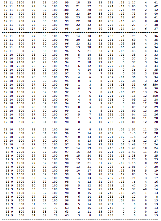
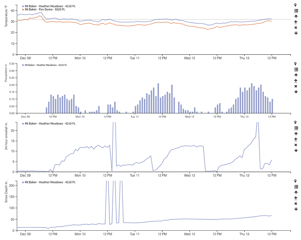
Following 25" of new snow since noon yesterday, the snowdepth at the 4200 ft Mount Baker Ski Area site hit 67" just after noon today Thursday, December 13. This is over 100% of normal depth for this date, as the December 15 normal is 67" at this site according to the NWAC Climatological Snowdepth data. Before the current storm cycle began on December 9, the snowdepth was only 13" at this site, only 20% of normal for that date! Just a very remarkable change in snowpack in such a short period, even for one of the snowiest measurement sites in the entire world. Total snowfall at Baker Ski Area over the 4-day period has been over 5 ft, with precip of over 7".
Unfortunately the new snowfall severely impacted operations at the ski area, which opened for the season only the day before on December 12, but was unable to open anything December 13 until noon, and even then only 2 lifts. From their website at noon, "Mt. Baker got absolutely hammered with an extreme amount of new snow and stormy, windy conditions last night. As we got out on the mountain this morning to prepare for opening we discovered that in some places the new snow drifted as deep as 4-5 feet. The avalanche danger is extreme and we are still doing avalanche control work. Chairs 5 & 7 are open, but the rest of the mountain will remain closed today as we continue to do avalanche control work." NWAC also posted their first Avalanche Warning of the season this morning, updating the Northwest Cascades zone which includes Mount Baker at 9:30am to "High" avalanche danger at all elevations.
Other sites in the WA Cascades have also gotten heavy snowfall as forecast over these 4 days, although nothing close to Baker's amounts. The snowdepth at 5400 ft Paradise on Mount Rainier reached 59" this morning after 15" new (before settling a few inches after that), which is almost 90% of normal for this date (December 15 normal is 68" per NWAC). On December 9, the snowdepth was only 22" at this site, about 35% of normal for that date. Total snowfall at Paradise over the 4-day period has been almost 4 ft, with precip of over 5".
At Stevens Pass, snowdepth at the 3950 ft measurement site reached 41" this morning after 11" new, almost 100% of normal for this date (December 15 normal is 43" per NWAC). On December 9, the snowdepth was only 16" at this site, about 40% of normal for that date. At their higher 4800 ft Brooks site, snowdepth increased from 24" to 58", although no normal values are available to calculate percentages. Total snowfall at Stevens Pass over the 4-day period has been about 3 ft, with precip of over 3", while the higher Brooks site got almost 4 ft with precip of over 4".
Even Snoqualmie Pass has made a major improvement in snowdepth the last 4 days, despite quite a bit of rain at times. The snowdepth at the 3000 ft measurement site reached 31" this morning after 8" new, almost 90% of normal for this date (December 15 normal is 36" per NWAC). Previously there was only 8" snowdepth on December 9, about 25% of normal for that date. Total snowfall at Snoqualmie Pass over the 4-day period has been about 2.5 ft, with precip of about 7", reflecting the large admixture of rain between periods of snowfall.
But the single greatest 24-hour snowfall during these storms wasn't actually at any of these high-snowfall locations. It was at 1930 ft Lake Wenatchee, which got 26" of new snow in less than 24 hours on December 11! This increased their snowdepth from a mere 2" to 25", before a changeover to rain at midnight followed by significant settlement.
The forecast calls for continued storminess and snowfall over the next several days in the WA Cascades. This means that many more measurement sites should be close to or even over 100% of normal snowdepth by early next week.
[hr]Here is the NWAC telemetry from Baker Ski Area and Rainier Paradise / Camp Muir covering the 4 day period from December 9-13:
Please Log in or Create an account to join the conversation.
- RonL
-
- User
-
Less
More
- Posts: 259
- Thank you received: 0
7 years 7 months ago #232117
by RonL
Replied by RonL on topic Re: Baker snowdepth up from 20% to 100% 09-13Dec2018!
Thanks for the perspective on the storm. It will be interesting to see what happened in the baker bc on the usual slide zones, if they ran further than normal and if the prestorm layers we're crushed.
Please Log in or Create an account to join the conversation.