- Posts: 125
- Thank you received: 0
East/Norse Peak Fire, Do not wear white up there!
- Eric Lindahl
-
 Topic Author
- User
-

Less
More
8 years 9 months ago #230008
by Eric Lindahl
Replied by Eric Lindahl on topic Re: East/Norse Peak Fire, Do not wear white up there!
I meant to add to bring a garbage sack and spare clothes in case you really get into it.
I have heard that the slopes of the Crystal drainage were denuded of trees for structures and mine supports around the turn of the last century.
I often see really nice slopes where its obvious that fire had done its job of clearing decades before. I usually give thanks for that.
Cool picture Lowell. Thanks.
On another note, psa: There is a ~16" diameter fallen tree across the Bullion Basin trail about 1.5 miles up the trail. Its about hip level at the highest point. Unless we have a better than average snow year I think it will be a pain for every one who skins up there. Might be able to get around it ok once several feet of snow falls. But I am hoping the forest service or who ever is responsible will get up there with a chainsaw and take care of it........
Please Log in or Create an account to join the conversation.
- skibacks
-
- User
-
Less
More
- Posts: 64
- Thank you received: 0
8 years 9 months ago #230010
by skibacks
Replied by skibacks on topic Re: East/Norse Peak Fire, Do not wear white up there!
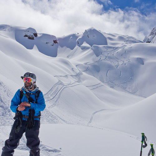
Great beta Eric and what an awesome photo - thanks for sharing, Lowell. A great vista of Ted's Buttress which is the ridgeline where the shade meets the sun just right of the skier. There are some small trees now where the biggest trees are in the photo, just right of the skier's head. The bigger trees in the photo were "flushed" in a slide which nearly reached Forelaufer's Ski Club, decades ago There have been several avalanche accidents in Ted's over the years - usually just broken legs. The prevailing winds load the area left of the ridge. Kim Kircher noted that quite a few trees higher up were burned which could create a new starting zone. I am interested to see how the old slide path down valley near the Sand Flats will perform. There was a slide in 1972 that went from east to west and covered the BLVD with about 15-20 feet of snow & logs.
Please Log in or Create an account to join the conversation.
- r1de
-
- User
-
Less
More
- Posts: 90
- Thank you received: 0
8 years 8 months ago #230088
by r1de
Isn't this whole area still closed?
www.fs.usda.gov/alerts/mbs/alerts-notices
Please tell me I'm wrong.
Replied by r1de on topic Re: East/Norse Peak Fire, Do not wear white up there!
On another note, psa:  There is a ~16" diameter fallen tree across the Bullion Basin trail about 1.5 miles up the trail. Its about hip level at the highest point. Unless we have a better than average snow year I think it will be a pain for every one who skins up there. Might be able to get around it ok once several feet of snow falls. But I am hoping the forest service or who ever is responsible will get up there with a chainsaw and take care of it........
Isn't this whole area still closed?
www.fs.usda.gov/alerts/mbs/alerts-notices
Please tell me I'm wrong.
Please Log in or Create an account to join the conversation.
- Norseman
-
- User
-
Less
More
- Posts: 55
- Thank you received: 0
8 years 8 months ago #230062
by Norseman
That is a closure that will be flat out ignored by the touring crowd (I hope). Good f'n luck enforcing it.
Replied by Norseman on topic Re: East/Norse Peak Fire, Do not wear white up there!
Isn't this whole area still closed?
www.fs.usda.gov/alerts/mbs/alerts-notices
Please tell me I'm wrong.
That is a closure that will be flat out ignored by the touring crowd (I hope). Good f'n luck enforcing it.
Please Log in or Create an account to join the conversation.
- Kiddch
-
- User
-
Less
More
- Posts: 24
- Thank you received: 0
8 years 8 months ago #230089
by Kiddch
Replied by Kiddch on topic Re: East/Norse Peak Fire, Do not wear white up there!
Wow. By the letter of the law, between the Baker-Snoqualmie closures in Pierce Co. and the Okanogan-Wenatchee closures in Yakima Co., widespread popular areas to the east and north of Crystal, including Norse Peak, East Peak, Cement Basin, Bullion Basin and Blue Bell, are under closure order.
Lots of interesting questions I can think of here, but maybe don't ask/don't tell is the approach, let people do what they are going to do? I guess we may not see many trip reports (cough....evidence....cough) out of those areas for a while.
Seriously, stay safe. When is the last experience the bc community has with widespread fire damage in that popular of a touring area, and how stability is effected?
Having already toured East Peak and Cement and Bullion Basins I was hoping to check out Blue Bell next. We'll see. Ridge from Crown Point to Three Way may get busier for a little. Hope this doesn't drive too much more traffic into south facing aspects where risks can be harder to manage.....
Please Log in or Create an account to join the conversation.
- CBAlliance
-
- User
-
Less
More
- Posts: 29
- Thank you received: 0
8 years 8 months ago #230097
by CBAlliance
Replied by CBAlliance on topic Re: East/Norse Peak Fire, Do not wear white up there!
Called and talked to the FS office in Enumclaw today. Stated reason for the continued closure was that they need to go in and assess the area for public safety, due to the hazard of burned and weakened trees falling on people. I asked when this would happen, and was told it was weather dependent but they were trying to do it soon, and certainly before the closure expired on Dec 31st.
Not really clear on what would be assessed, or what sort of standards are required to re-open an area. We will come up with some sort of official missive soon to hopefully let the FS know how valuable these areas are to the ski community, but that's the word currently.
Not really clear on what would be assessed, or what sort of standards are required to re-open an area. We will come up with some sort of official missive soon to hopefully let the FS know how valuable these areas are to the ski community, but that's the word currently.
Please Log in or Create an account to join the conversation.