- Posts: 141
- Thank you received: 0
Lyman Lake SNOTEL hits 100" snowdepth!?! 05Jan2015
- ski_photomatt
-

- User
-

Less
More
11 years 5 months ago #223547
by ski_photomatt
Thanks for the link Lowell, I hadn't seen it. If there's one thing I've learned about science it's that unanimous opinions are extremely rare, and the best we can hope for is consensus.
Replied by ski_photomatt on topic Re: Lyman Lake SNOTEL hits 100" snowdepth!?! 05Jan2015
I don't dispute that Washington snowpack has declined, but you may be aware that there's been a fair amount of debate about the magnitude, and the debate has involved some quite knowledgeable local weather and climate people. The following article from a few years ago is interesting:
seattletimes.com/html/localnews/2003618979_warming15m.html
You can read more arguments on either side by googling "myth of vanishing cascade snowpack".
Thanks for the link Lowell, I hadn't seen it. If there's one thing I've learned about science it's that unanimous opinions are extremely rare, and the best we can hope for is consensus.
Please Log in or Create an account to join the conversation.
- Amar Andalkar
-
Topic Author
- User
-
Less
More
- Posts: 635
- Thank you received: 0
11 years 5 months ago - 11 years 5 months ago #223598
by Amar Andalkar
Replied by Amar Andalkar on topic Re: Lyman Lake SNOTEL hits 100" snowdepth!?! 05Jan2015
UPDATE 18Jan2015: Well, today Lyman Lake SNOTEL really did break 100" easily, and it once again has the greatest snowdepth of any SNOTEL site in the country, and probably the greatest snowdepth of any measurement site in North America too!
Another very wet, very warm storm system (the oft-repeated pattern of the early part of the 2014-15 season in the Pacific Northwest) on Saturday-Sunday January 17-18 brought 2-5" of precip to most sites near and west of the crest throughout the Washington and northern Oregon Cascades. This was mostly in the form of torrential rain with rainfall rates exceeding 0.5" per hour (!) on Mount Hood and snow levels rising to 7000-8000 ft, with all rain and no snowfall through Sunday morning at sites such as Mount Hood Timberline (5900 ft) and Meadows (5400 ft), Mount Rainier Paradise (5400 ft), and Mount Baker Ski Area (4200 ft).
But as usual so far this season, high-elevation sites in the North Cascades especially east of the Cascade Crest were insulated from most of the warming aloft by the deep pool of colder air which typically fills Eastern Washington during winter, and instead of pouring rain, the precip remained mostly snow. The Lyman Lake SNOTEL site located just a half-mile east of the crest near Holden received about 20" of new snowfall, bringing its snowdepth up to 106" as of midday Sunday (Monday morning update 19Jan2015: now 112", with about 30" of total new snow in the past 48 hours, including the effects of settlement):
[tt]
Lyman Lake (606)
Washington SNOTEL Site - 5980 ft
Snow Precip
Water Snow since Air
Date / Time Equiv Depth Oct 1 Temp
(PST) (in) (in) (in) (°F)
2015-01-17 00:00 27.5 89 40.5 23
2015-01-17 01:00 27.5 89 40.5 23
2015-01-17 02:00 27.5 90 40.5 24
2015-01-17 03:00 27.5 88 40.5 25
2015-01-17 04:00 27.5 89 40.5 24
2015-01-17 05:00 27.5 86 40.5 25
2015-01-17 06:00 27.5 87 40.5 24
2015-01-17 07:00 27.5 88 40.5 24
2015-01-17 08:00 27.5 88 40.5 23
2015-01-17 09:00 27.6 88 40.5 25
2015-01-17 10:00 27.6 87 40.5 26
2015-01-17 11:00 27.6 89 40.5 25
2015-01-17 12:00 27.6 90 40.4 26
2015-01-17 13:00 27.6 90 40.4 28
2015-01-17 14:00 27.7 90 40.4 29
2015-01-17 15:00 27.7 90 40.4 29
2015-01-17 16:00 27.7 86 40.5 28
2015-01-17 17:00 27.8 90 40.5 27
2015-01-17 18:00 27.9 90 40.5 28
2015-01-17 19:00 28.0 91 40.6 27
2015-01-17 20:00 28.1 92 40.6 28
2015-01-17 21:00 28.2 94 40.6 25
2015-01-17 22:00 28.4 97 40.6 25
2015-01-17 23:00 28.5 98 40.6 26
2015-01-18 00:00 28.7 100 40.6 27
2015-01-18 01:00 28.8 101 40.6 27
2015-01-18 02:00 28.9 102 41.2 37 <<< note temp & precip
2015-01-18 03:00 29.0 102 41.7 35 <<< note temp & precip
2015-01-18 04:00 29.1 100 41.7 31
2015-01-18 05:00 29.1 102 41.7 31
2015-01-18 06:00 29.2 103 41.8 31
2015-01-18 07:00 29.3 103 41.9 31
2015-01-18 08:00 29.4 103 41.8 31
2015-01-18 09:00 29.5 104 41.9 31
2015-01-18 10:00 29.6 103 42.0 30
2015-01-18 11:00 29.6 104 42.0 30
2015-01-18 12:00 29.8 105 42.1 30
2015-01-18 13:00 29.9 106 42.2 30
2015-01-18 15:00 30.0 107 42.2 30
2015-01-18 16:00 30.0 107 42.2 29
2015-01-18 17:00 30.1 108 42.2 28
2015-01-18 18:00 30.2 109 42.2 28
2015-01-18 19:00 30.3 109 42.2 28
2015-01-18 20:00 30.3 109 42.2 28
2015-01-18 21:00 30.3 109 42.3 28
2015-01-18 22:00 30.4 109 42.3 28
2015-01-18 23:00 30.5 110 42.2 28
2015-01-19 00:00 30.6 110 42.3 28
2015-01-19 01:00 30.6 42.3 28
2015-01-19 02:00 30.6 109 42.3 28
2015-01-19 03:00 30.6 111 42.3 28
2015-01-19 04:00 30.6 109 42.3 28
2015-01-19 05:00 30.6 110 42.3 28
2015-01-19 06:00 30.6 110 42.3 27
2015-01-19 07:00 30.8 112 42.3 27
[/tt]
The temperature did briefly spike well above freezing at 2-3am, but then quickly dropped back below freezing, and the brief rain was not enough to compact the new snow too much. Interestingly, the precip totals shot up suddenly during the 2 warm hours, due to the melting of a plug of new snow stuck in the top of the unheated precip gauge -- a typical issue on SNOTEL sites, which have a storage-type precip gauge consisting of a tall cylinder partially filled with antifreeze, with a pressure sensor at the bottom recording the depth of the water-antifreeze mixture, and a calibration equation to calculate the displayed precip total. This is very different than the heated tipping-bucket precip gauge used at NWAC sites, which records 0.01" every time its little cup fills with melted precip and tips back and forth. Note also that the increase in SWE is still greater than the recorded precip even after the frozen plug melted, a combination of undercatch by the precip gauge during windy snowfall (the Alter wind screen atop the gauge helps in this regard, but is not nearly 100% effective) and possibly some unmelted snow still stuck near the top of the gauge.
Even though it's located right on the Cascade Crest, Stevens Pass lucked out this time with strong easterly pass flow protecting it the same way, with 16" of new snow by 2am Sunday. Then the winds reversed to southwesterly by 3am, the temperature spiked by 6 °F, and the snow changed to rain:
[tt]
Northwest Avalanche Center
Stevens Pass Ski Area Brooks Chair (4850')
Washington Department of Transportation Schmidt Haus (3950')
Stevens Pass, Washington
MM/DD Hour Temp Temp RH RH Wind Wind Wind Hour Total 24 Hr Total Press
PST F F % % Avg Max Dir Prec Prec Snow Snow mb
4850' 3950' 4850' 3950' 4850' 4850' 4850' 3950' 3950' 3950' 3950' 3950'
1 17 1000 25 28 100 90 9 15 62 0 0 0 35 1015
1 17 1100 25 28 100 91 9 16 50 .02 .02 0 35 1014
1 17 1200 25 28 100 94 7 15 46 .1 .12 2 36 1013
1 17 1300 25 27 100 94 8 17 38 .09 .21 2 37 1012
1 17 1400 25 28 100 95 8 15 39 .1 .31 3 37 1011
1 17 1500 26 28 100 95 9 19 39 .09 .4 4 37 1011
1 17 1600 25 27 100 95 7 15 46 .11 .51 4 39 1011
1 17 1700 25 28 100 95 7 14 49 .08 .59 5 40 1011
1 17 1800 25 27 100 94 9 17 46 .11 .7 6 41 1010
1 17 1900 25 27 100 95 8 17 46 .11 .81 7 42 1010
1 17 2000 25 27 100 95 8 17 51 .19 1 9 43 1009
1 17 2100 25 27 100 96 10 19 41 .15 1.15 11 44 1008
1 17 2200 25 27 100 95 10 18 46 .19 1.34 12 46 1007
1 17 2300 25 27 100 94 9 18 53 .16 1.5 14 48 1007
1 18 0 24 27 100 94 9 18 55 .17 1.67 16 49 1006
1 18 100 26 28 100 94 8 21 47 .04 1.71 16 49 1005
1 18 200 32 29 100 96 3 15 22 .11 1.82 16 49 1005
1 18 300 33 35 99 91 11 38 241 .04 1.86 15 49 1006 <<< wind shift
1 18 400 33 34 96 93 9 26 243 .03 1.89 15 49 1007
1 18 500 32 34 93 93 11 29 242 .04 1.93 15 49 1006
1 18 600 32 35 100 93 10 36 252 .04 1.97 0 49 1006
1 18 700 32 35 100 92 13 46 247 .1 2.07 0 49 1007
1 18 800 31 34 100 93 12 27 236 .11 2.18 0 49 1009
1 18 900 31 34 100 94 11 32 230 .07 2.25 0 49 1011
[/tt]
Even low-elevation sites east of the crest stayed all-snow through early Sunday morning, with 9" new at the Mazama NWAC site (2170 ft), 12" new at Holden Village (3220 ft) 6 miles east of Lyman Lake, about 16" new at the Trinity SNOTEL site (2930 ft) 9 miles SSE of Lyman Lake, 15" new at the Berne NWAC site (2700 ft) east of Stevens Pass, 11" new at the Lake Wenatchee NWAC site (1930 ft), and about 15" new at the Fish Lake SNOTEL site (3430 ft) along Cle Elum River Road.
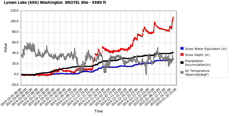
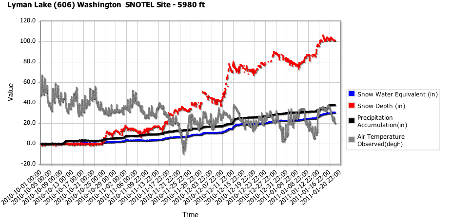
Back to Lyman Lake: Here is a plot of snowdepth, snow water, precip, and temperature since the start of the water year on October 1, made using the NRCS Report Generator , which shows it hitting 99" on January 5 and finally breaking 100" today:
Just for fun, I decided to make the same plot for each of the past 6 years at Lyman Lake, from October 1 to January 18:
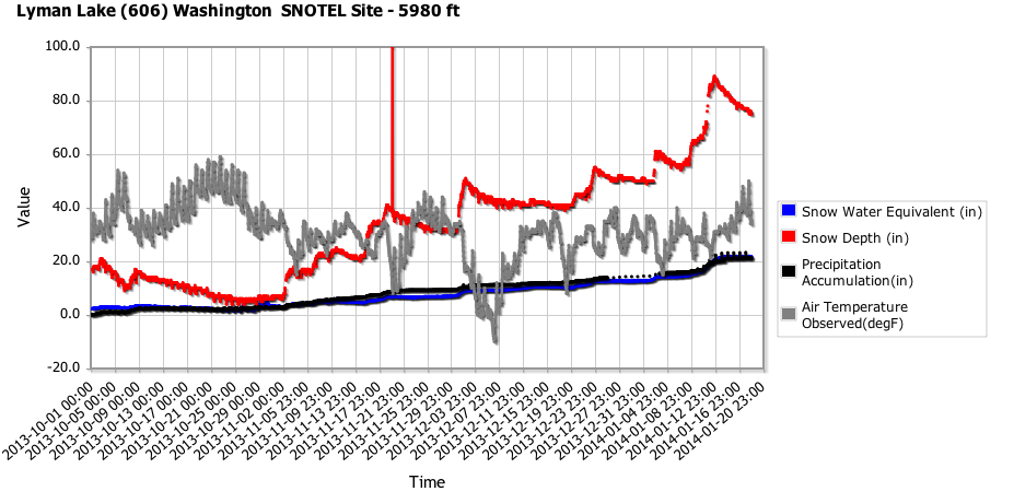
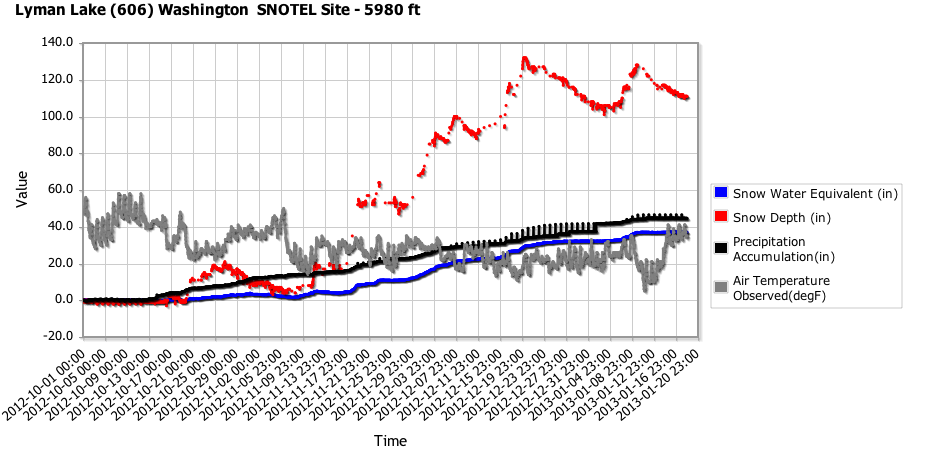
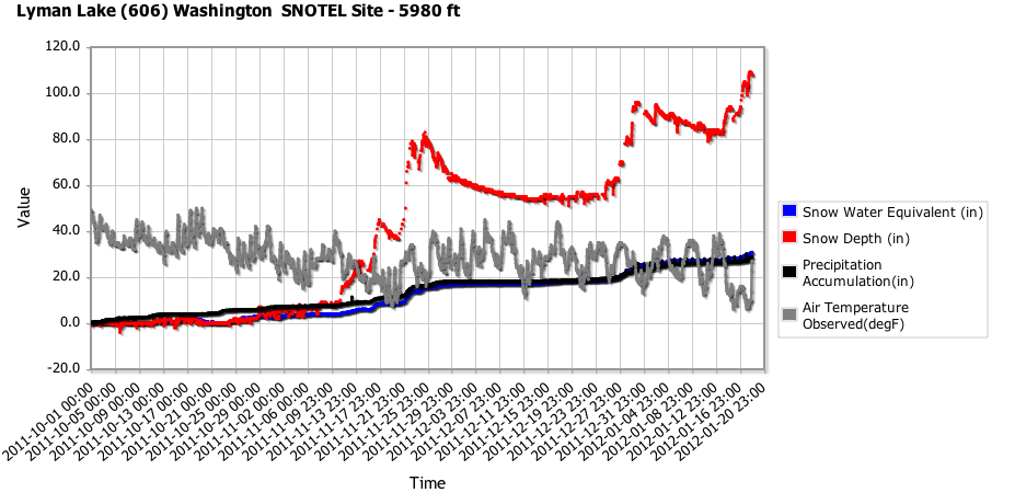
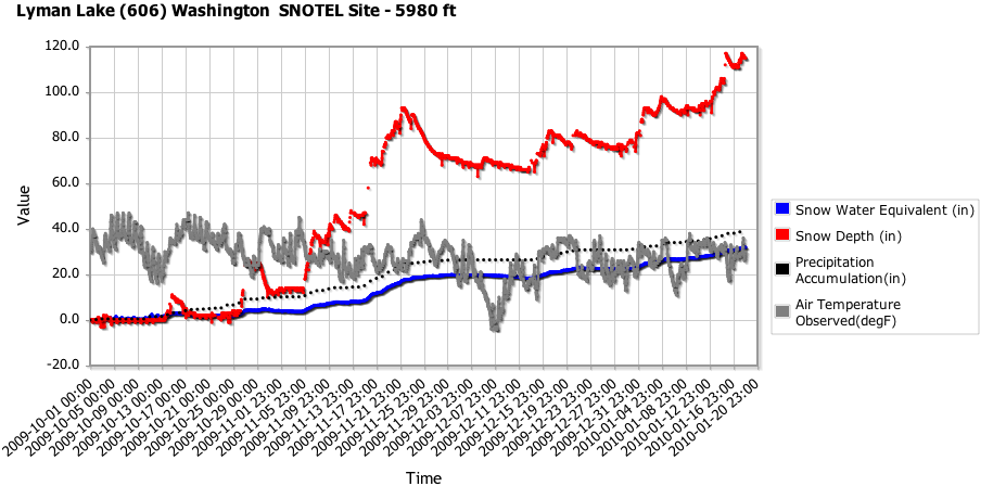
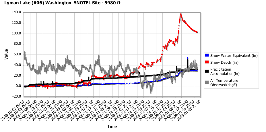
Interestingly, looking at these plots, I noticed that the snowdepth on January 18 has been almost identical within a few % of 110" for 6 of the past 7 years, with only 2014 falling well short of the others (the maximum value at any hour on January 18 is listed here):
[tt]
18Jan2015: 110"
18Jan2014: 77"
18Jan2013: 112"
18Jan2012: 109"
18Jan2011: 102"
18Jan2010: 117"
18Jan2009: 104"
[/tt]
Ironically, the second lowest of these values is in 2011, a huge La Nina year which was far above-normal overall at almost all snow measurement sites on the entire West Coast, and ranks as one of the all-time great summer snowpacks in Pacific Northwest history, matched only by 1974 in that regard. Anyway, the point of the graphical comparison was to demonstrate that at least in some small portions of the Cascades like Lyman Lake, this year is not below-normal for snowpack at all and is in fact fairly typical.
Compared to other measurement sites in the US, Lyman Lake SNOTEL is now the clear leader in snowdepth at106" 112", with no other sites closer than 12" to it, as far as I can find at this time. Its closest competitors in the Cascades are the
Brown Top SNOTEL
(5830 ft) in the North Cascades which stayed mostly snow despite temps well above freezing and got about 14" new bringing it up to 89" on Sunday morning, along with
Harts Pass SNOTEL
(6490 ft) which was all snow with temps well below freezing, and about 10" new bringing it up to 82" on Sunday morning. The
California Cooperative Snow Surveys telemetry site on Lassen Peak
at 8250 ft near Lake Helen has settled to about 86" from its maximum of about 110" in late December (almost no new snow since December 21), which still remains the greatest snowdepth yet recorded this season at any site. Lyman Lake should easily pass that over the next day based on current forecasts (see below). Update 19Jan2015: Lyman Lake has passed Lassen's earlier mark with 112" as of Monday morning.
In the Rockies, the Moss Peak (6780 ft), North Fork Jocko (6330 ft), and Noisy Basin (6040 ft) SNOTEL sites in Montana all reached about 93-94" on Sunday morning after about 6-10" new overnight, while the Grand Targhee SNOTEL (9260 ft) in Wyoming had 86" on Saturday and is probably about 94" as of Sunday morning based on overnight precip and SWE increases (snowdepth temporarily out).
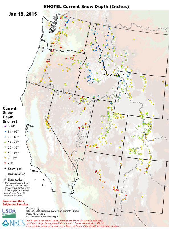
Here is an overview of current snowdepth from the SNOTEL network throughout the western US (except Alaska which is having a very poor snow year too, and most of California which has a separate state-run network):
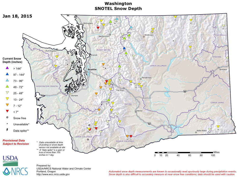
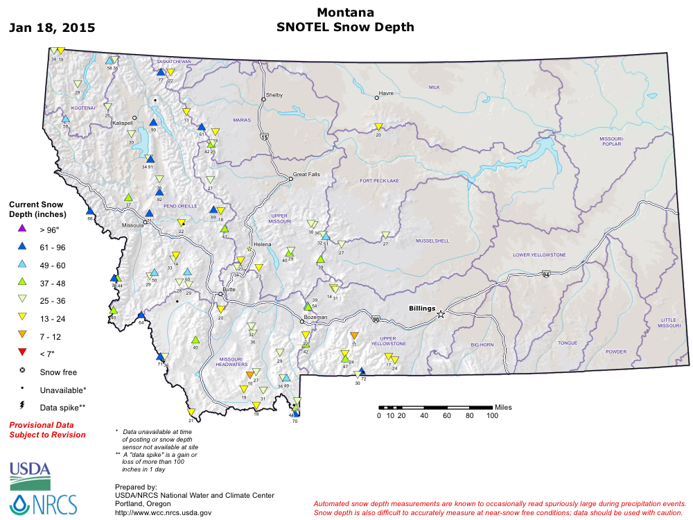
And also zoomed in on Washington and Montana to easily see the highest snowdepth sites, with values listed as of midnight January 18:
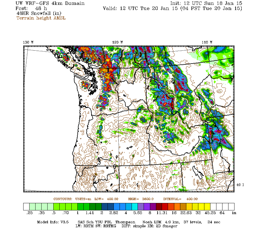
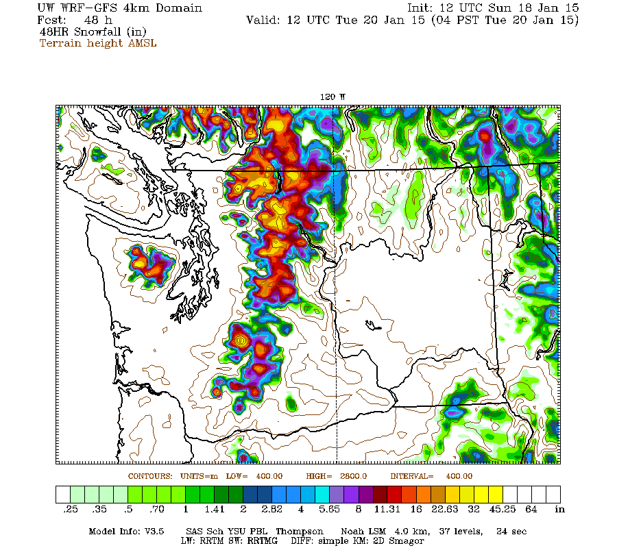
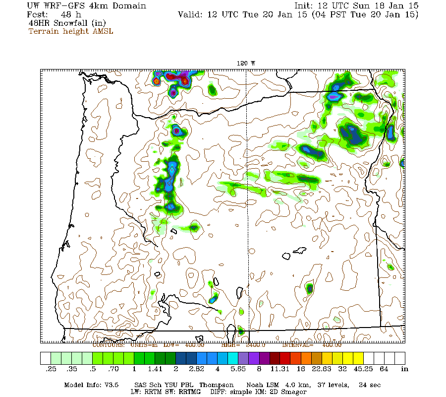
Regarding snowpack, very little has changed throughout the western US in the 2 weeks since this thread was started, although now that the cold front is passing and heavy rain is changing to snowfall, the snowpack should get a decent boost especially in Washington by late Monday. The high-resolution UW WRF-GFS model is predicting new snowfall amounts of up to 1-3 ft over the next 48 hours through 4am Tuesday for the Washington Cascades, with lesser amounts of up to 4-8" extending into the northern Oregon Cascades:
Another very wet, very warm storm system (the oft-repeated pattern of the early part of the 2014-15 season in the Pacific Northwest) on Saturday-Sunday January 17-18 brought 2-5" of precip to most sites near and west of the crest throughout the Washington and northern Oregon Cascades. This was mostly in the form of torrential rain with rainfall rates exceeding 0.5" per hour (!) on Mount Hood and snow levels rising to 7000-8000 ft, with all rain and no snowfall through Sunday morning at sites such as Mount Hood Timberline (5900 ft) and Meadows (5400 ft), Mount Rainier Paradise (5400 ft), and Mount Baker Ski Area (4200 ft).
But as usual so far this season, high-elevation sites in the North Cascades especially east of the Cascade Crest were insulated from most of the warming aloft by the deep pool of colder air which typically fills Eastern Washington during winter, and instead of pouring rain, the precip remained mostly snow. The Lyman Lake SNOTEL site located just a half-mile east of the crest near Holden received about 20" of new snowfall, bringing its snowdepth up to 106" as of midday Sunday (Monday morning update 19Jan2015: now 112", with about 30" of total new snow in the past 48 hours, including the effects of settlement):
[tt]
Lyman Lake (606)
Washington SNOTEL Site - 5980 ft
Snow Precip
Water Snow since Air
Date / Time Equiv Depth Oct 1 Temp
(PST) (in) (in) (in) (°F)
2015-01-17 00:00 27.5 89 40.5 23
2015-01-17 01:00 27.5 89 40.5 23
2015-01-17 02:00 27.5 90 40.5 24
2015-01-17 03:00 27.5 88 40.5 25
2015-01-17 04:00 27.5 89 40.5 24
2015-01-17 05:00 27.5 86 40.5 25
2015-01-17 06:00 27.5 87 40.5 24
2015-01-17 07:00 27.5 88 40.5 24
2015-01-17 08:00 27.5 88 40.5 23
2015-01-17 09:00 27.6 88 40.5 25
2015-01-17 10:00 27.6 87 40.5 26
2015-01-17 11:00 27.6 89 40.5 25
2015-01-17 12:00 27.6 90 40.4 26
2015-01-17 13:00 27.6 90 40.4 28
2015-01-17 14:00 27.7 90 40.4 29
2015-01-17 15:00 27.7 90 40.4 29
2015-01-17 16:00 27.7 86 40.5 28
2015-01-17 17:00 27.8 90 40.5 27
2015-01-17 18:00 27.9 90 40.5 28
2015-01-17 19:00 28.0 91 40.6 27
2015-01-17 20:00 28.1 92 40.6 28
2015-01-17 21:00 28.2 94 40.6 25
2015-01-17 22:00 28.4 97 40.6 25
2015-01-17 23:00 28.5 98 40.6 26
2015-01-18 00:00 28.7 100 40.6 27
2015-01-18 01:00 28.8 101 40.6 27
2015-01-18 02:00 28.9 102 41.2 37 <<< note temp & precip
2015-01-18 03:00 29.0 102 41.7 35 <<< note temp & precip
2015-01-18 04:00 29.1 100 41.7 31
2015-01-18 05:00 29.1 102 41.7 31
2015-01-18 06:00 29.2 103 41.8 31
2015-01-18 07:00 29.3 103 41.9 31
2015-01-18 08:00 29.4 103 41.8 31
2015-01-18 09:00 29.5 104 41.9 31
2015-01-18 10:00 29.6 103 42.0 30
2015-01-18 11:00 29.6 104 42.0 30
2015-01-18 12:00 29.8 105 42.1 30
2015-01-18 13:00 29.9 106 42.2 30
2015-01-18 15:00 30.0 107 42.2 30
2015-01-18 16:00 30.0 107 42.2 29
2015-01-18 17:00 30.1 108 42.2 28
2015-01-18 18:00 30.2 109 42.2 28
2015-01-18 19:00 30.3 109 42.2 28
2015-01-18 20:00 30.3 109 42.2 28
2015-01-18 21:00 30.3 109 42.3 28
2015-01-18 22:00 30.4 109 42.3 28
2015-01-18 23:00 30.5 110 42.2 28
2015-01-19 00:00 30.6 110 42.3 28
2015-01-19 01:00 30.6 42.3 28
2015-01-19 02:00 30.6 109 42.3 28
2015-01-19 03:00 30.6 111 42.3 28
2015-01-19 04:00 30.6 109 42.3 28
2015-01-19 05:00 30.6 110 42.3 28
2015-01-19 06:00 30.6 110 42.3 27
2015-01-19 07:00 30.8 112 42.3 27
[/tt]
The temperature did briefly spike well above freezing at 2-3am, but then quickly dropped back below freezing, and the brief rain was not enough to compact the new snow too much. Interestingly, the precip totals shot up suddenly during the 2 warm hours, due to the melting of a plug of new snow stuck in the top of the unheated precip gauge -- a typical issue on SNOTEL sites, which have a storage-type precip gauge consisting of a tall cylinder partially filled with antifreeze, with a pressure sensor at the bottom recording the depth of the water-antifreeze mixture, and a calibration equation to calculate the displayed precip total. This is very different than the heated tipping-bucket precip gauge used at NWAC sites, which records 0.01" every time its little cup fills with melted precip and tips back and forth. Note also that the increase in SWE is still greater than the recorded precip even after the frozen plug melted, a combination of undercatch by the precip gauge during windy snowfall (the Alter wind screen atop the gauge helps in this regard, but is not nearly 100% effective) and possibly some unmelted snow still stuck near the top of the gauge.
Even though it's located right on the Cascade Crest, Stevens Pass lucked out this time with strong easterly pass flow protecting it the same way, with 16" of new snow by 2am Sunday. Then the winds reversed to southwesterly by 3am, the temperature spiked by 6 °F, and the snow changed to rain:
[tt]
Northwest Avalanche Center
Stevens Pass Ski Area Brooks Chair (4850')
Washington Department of Transportation Schmidt Haus (3950')
Stevens Pass, Washington
MM/DD Hour Temp Temp RH RH Wind Wind Wind Hour Total 24 Hr Total Press
PST F F % % Avg Max Dir Prec Prec Snow Snow mb
4850' 3950' 4850' 3950' 4850' 4850' 4850' 3950' 3950' 3950' 3950' 3950'
1 17 1000 25 28 100 90 9 15 62 0 0 0 35 1015
1 17 1100 25 28 100 91 9 16 50 .02 .02 0 35 1014
1 17 1200 25 28 100 94 7 15 46 .1 .12 2 36 1013
1 17 1300 25 27 100 94 8 17 38 .09 .21 2 37 1012
1 17 1400 25 28 100 95 8 15 39 .1 .31 3 37 1011
1 17 1500 26 28 100 95 9 19 39 .09 .4 4 37 1011
1 17 1600 25 27 100 95 7 15 46 .11 .51 4 39 1011
1 17 1700 25 28 100 95 7 14 49 .08 .59 5 40 1011
1 17 1800 25 27 100 94 9 17 46 .11 .7 6 41 1010
1 17 1900 25 27 100 95 8 17 46 .11 .81 7 42 1010
1 17 2000 25 27 100 95 8 17 51 .19 1 9 43 1009
1 17 2100 25 27 100 96 10 19 41 .15 1.15 11 44 1008
1 17 2200 25 27 100 95 10 18 46 .19 1.34 12 46 1007
1 17 2300 25 27 100 94 9 18 53 .16 1.5 14 48 1007
1 18 0 24 27 100 94 9 18 55 .17 1.67 16 49 1006
1 18 100 26 28 100 94 8 21 47 .04 1.71 16 49 1005
1 18 200 32 29 100 96 3 15 22 .11 1.82 16 49 1005
1 18 300 33 35 99 91 11 38 241 .04 1.86 15 49 1006 <<< wind shift
1 18 400 33 34 96 93 9 26 243 .03 1.89 15 49 1007
1 18 500 32 34 93 93 11 29 242 .04 1.93 15 49 1006
1 18 600 32 35 100 93 10 36 252 .04 1.97 0 49 1006
1 18 700 32 35 100 92 13 46 247 .1 2.07 0 49 1007
1 18 800 31 34 100 93 12 27 236 .11 2.18 0 49 1009
1 18 900 31 34 100 94 11 32 230 .07 2.25 0 49 1011
[/tt]
Even low-elevation sites east of the crest stayed all-snow through early Sunday morning, with 9" new at the Mazama NWAC site (2170 ft), 12" new at Holden Village (3220 ft) 6 miles east of Lyman Lake, about 16" new at the Trinity SNOTEL site (2930 ft) 9 miles SSE of Lyman Lake, 15" new at the Berne NWAC site (2700 ft) east of Stevens Pass, 11" new at the Lake Wenatchee NWAC site (1930 ft), and about 15" new at the Fish Lake SNOTEL site (3430 ft) along Cle Elum River Road.
Back to Lyman Lake: Here is a plot of snowdepth, snow water, precip, and temperature since the start of the water year on October 1, made using the NRCS Report Generator , which shows it hitting 99" on January 5 and finally breaking 100" today:
Just for fun, I decided to make the same plot for each of the past 6 years at Lyman Lake, from October 1 to January 18:
Interestingly, looking at these plots, I noticed that the snowdepth on January 18 has been almost identical within a few % of 110" for 6 of the past 7 years, with only 2014 falling well short of the others (the maximum value at any hour on January 18 is listed here):
[tt]
18Jan2015: 110"
18Jan2014: 77"
18Jan2013: 112"
18Jan2012: 109"
18Jan2011: 102"
18Jan2010: 117"
18Jan2009: 104"
[/tt]
Ironically, the second lowest of these values is in 2011, a huge La Nina year which was far above-normal overall at almost all snow measurement sites on the entire West Coast, and ranks as one of the all-time great summer snowpacks in Pacific Northwest history, matched only by 1974 in that regard. Anyway, the point of the graphical comparison was to demonstrate that at least in some small portions of the Cascades like Lyman Lake, this year is not below-normal for snowpack at all and is in fact fairly typical.
Compared to other measurement sites in the US, Lyman Lake SNOTEL is now the clear leader in snowdepth at
In the Rockies, the Moss Peak (6780 ft), North Fork Jocko (6330 ft), and Noisy Basin (6040 ft) SNOTEL sites in Montana all reached about 93-94" on Sunday morning after about 6-10" new overnight, while the Grand Targhee SNOTEL (9260 ft) in Wyoming had 86" on Saturday and is probably about 94" as of Sunday morning based on overnight precip and SWE increases (snowdepth temporarily out).
Here is an overview of current snowdepth from the SNOTEL network throughout the western US (except Alaska which is having a very poor snow year too, and most of California which has a separate state-run network):
And also zoomed in on Washington and Montana to easily see the highest snowdepth sites, with values listed as of midnight January 18:
Regarding snowpack, very little has changed throughout the western US in the 2 weeks since this thread was started, although now that the cold front is passing and heavy rain is changing to snowfall, the snowpack should get a decent boost especially in Washington by late Monday. The high-resolution UW WRF-GFS model is predicting new snowfall amounts of up to 1-3 ft over the next 48 hours through 4am Tuesday for the Washington Cascades, with lesser amounts of up to 4-8" extending into the northern Oregon Cascades:
Please Log in or Create an account to join the conversation.
- Floater
-
- User
-
Less
More
- Posts: 23
- Thank you received: 0
11 years 5 months ago #223602
by Floater
Replied by Floater on topic Re: Lyman Lake SNOTEL hits 100" snowdepth!?! 05Jan2015
You ever stayed here in the Winter? This might be the ticket for this season. Sadly I am not Lutheran.
www.holdenvillage.org/village-life/
www.holdenvillage.org/village-life/
Please Log in or Create an account to join the conversation.