- Posts: 45
- Thank you received: 0
Spring storm cycle, 4-10 ft snow Mar25-Apr7,2014!
- swaterfall
-

- User
-

Less
More
12 years 2 months ago #221580
by swaterfall
Replied by swaterfall on topic Re: Spring storm cycle, 4-10 ft snow Mar25-Apr7,2014!
It's the most wonderful time of the year.
Please Log in or Create an account to join the conversation.
- Amar Andalkar
-
Topic Author
- User
-
Less
More
- Posts: 635
- Thank you received: 0
12 years 2 months ago - 12 years 2 months ago #221596
by Amar Andalkar
Replied by Amar Andalkar on topic Re: Spring storm cycle, 4-10 ft snow Mar25-Apr7,2014!
[size=small]I'm not planning to post daily updates for this storm cycle (especially on days that I'm out skiing), mainly to avoid overdoing it and burnout, but will try to update every 2 days or so if possible, or if something particularly interesting comes up. Anyway, here's an initial 1-day update:[/size]
Update #1: 24 hours after initial post, up to 1 ft of new snow has already fallen from southwestern BC to northern California,
with an additional 4-10 ft (perhaps more) still predicted over that region during the rest of March and into early April!
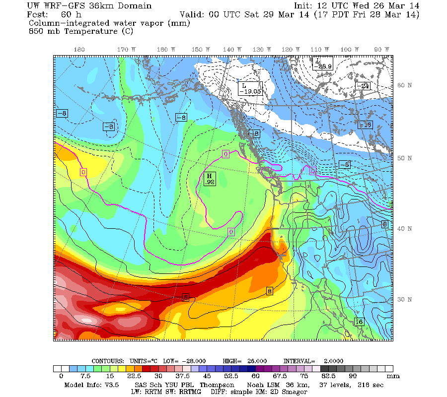
This major spring storm cycle is now well underway as of midday Wednesday, with new snowfall of a few inches to over 1 ft during the past 36 hours since midnight Monday-Tuesday extending from the central BC Coast Mountains near Smithers all the way to the southern end of the Sierra Nevada, a distance of over 1400 miles as the crow flies. Maximum 24-hour amounts reported as of Wednesday morning include 14" new at Whistler Mountain, 13" at Buckinghorse SNOTEL in the Olympics, 12" at Mount Baker Ski Area, and 10" at the summit of the Kirkwood, Sierra-at-Tahoe, and Mammoth Mountain ski areas in California. Not a very strong or very wet first system, but a very large one as seen in this visible satellite image from 4pm PDT Monday while the system was still off the West Coast:
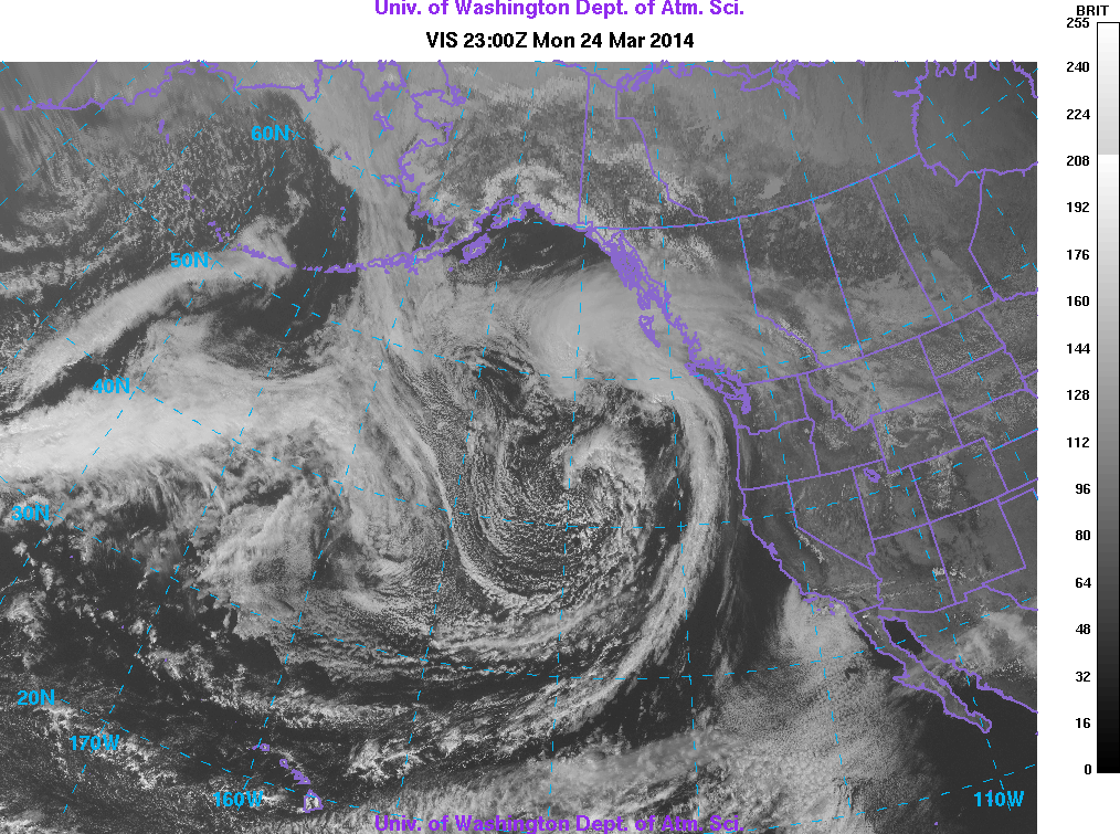
Quite interestingly, there were actually two low-pressure centers (one west of Oregon, the other west of the central BC coast) rotating about each other like a spinning dumbbell, see this animation of all Monday and Tuesday visible satellite images:
www.atmos.washington.edu/~ovens/wxloop.c...4032602+interval+30m
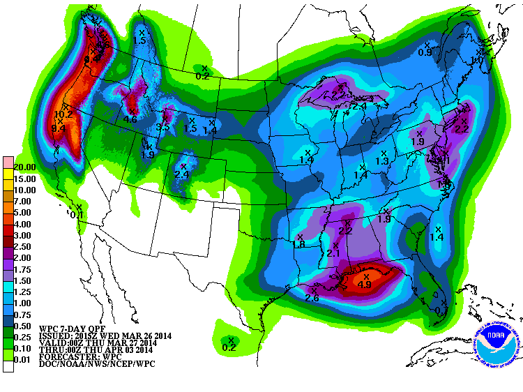
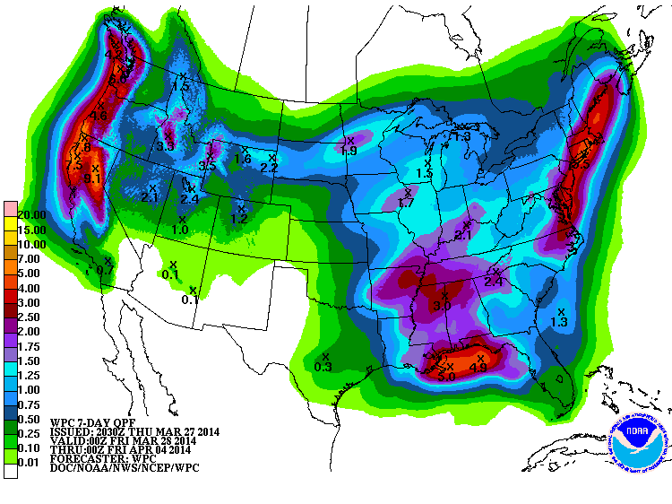
Model predictions continue on track with very heavy precip and snowfall expected over much of the West Coast during the next 7 days and beyond. The NWS's GFS model and their Quantitative Precipitation Forecasts are showing up to 6-10" of additional precip over the next week for the mountains of Washington, Oregon, and northern California, with 3-5" extending north into southwestern BC. Here is total precipitation in inches predicted over the next 7 days through the afternoon of Wednesday, April 2:
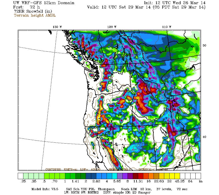
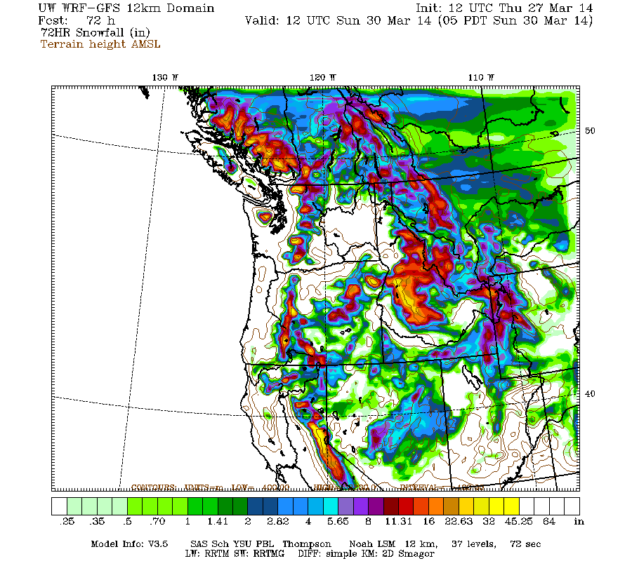
A day later, and 2 subsequent runs of the high-resolution UW WRF-GFS model at 12-hour intervals continue to predict large snowfall amounts up to 4-8 ft or more over the next week for the mountains of southwestern BC, Washington, Oregon, and northern California. Snowfall during the next 3 days from this morning through 5am Saturday is predicted to be 2-6 ft over the Oregon Cascades, California Cascades, Trinity Alps, and northern Sierra Nevada, with 1-3 ft for southwestern BC, the Olympics, and Washington Cascades:
This loop shows how the model predictions for snowfall during the 3-day period through 5am Saturday have evolved between 10 subsequent runs over the last 5 days, the D(model)/D(t). Very consistent in the overall picture throughout all those runs, with only minor variations in amounts -- so these model predictions are very likely to actually happen:
www.atmos.washington.edu/~ovens/wxloop.c...2+v2014032912///+-st
Higher resolution version of that, showing the Pacific Northwest and also zoomed in on Washington and Oregon:
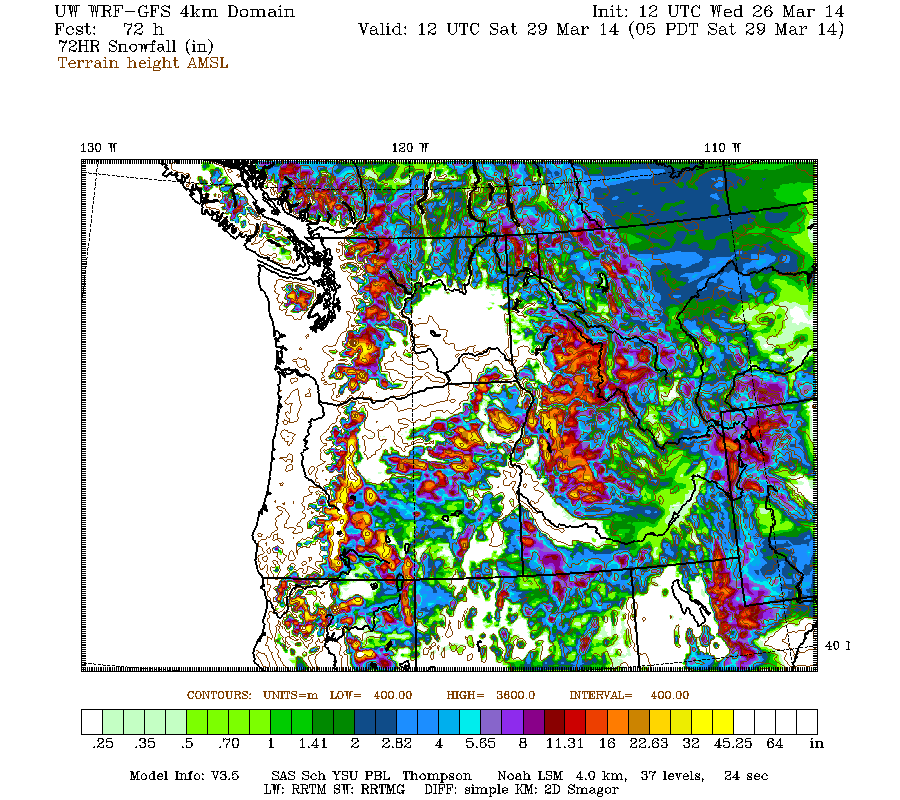
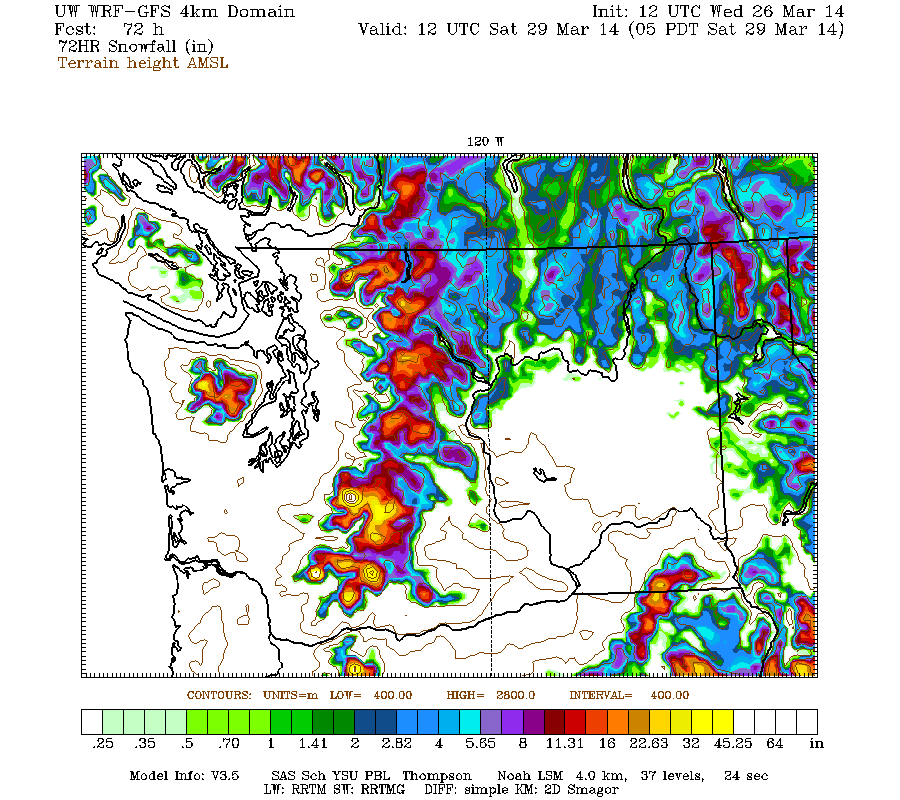
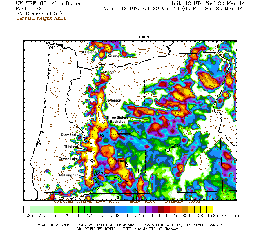
Maximum amounts of 4-6 ft (marked by white inside yellow) are shown on Mount Rainier, Mount Saint Helens, almost the entire Cascade Range in Oregon (above the 1600 m / 5300 ft contour), Mount Shasta, and Lassen Peak. In Oregon, this is by far the largest area with predicted 3-day amounts over 4 ft shown in any graphic in any of the 5 storm cycle threads thus far. If the model prediction verifies, this will be the largest 3-day snowfall in the central and southern Oregon Cascades of the entire 2013-14 season thus far. Even Newberry Volcano and Yamsay Mountain (another large shield volcano east of Crater Lake, the highest volcano in the eastern Cascade chain at 8196 ft) are shown with 3 ft of snowfall expected, unusual given that both are 30 miles east of the Cascade Crest and normally quite rain-shadowed! Some major volcanoes have been labeled on the last graphic for clarity.
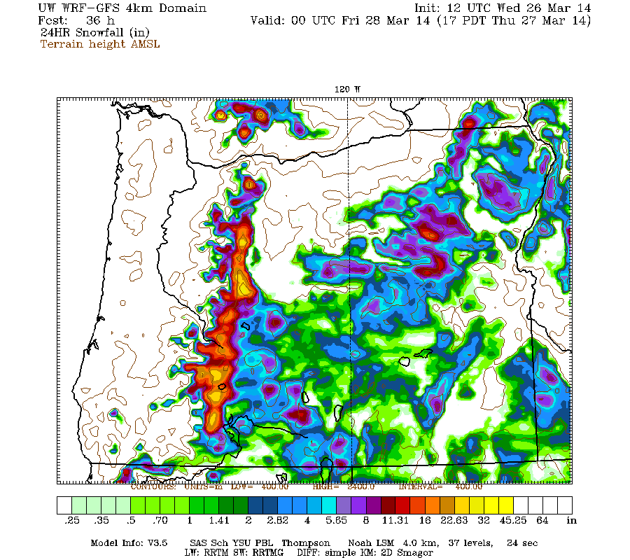
The extremely heavy snowfall in Oregon will occur during two separate systems, one from today into Thursday, and the other on Friday into Saturday. The 24-hour amounts during the first system through 5pm Thursday are predicted to top 2 ft on many of the volcanoes, with snowfall extending down to quite low elevations (3-4000 ft) for this time of year in that region:
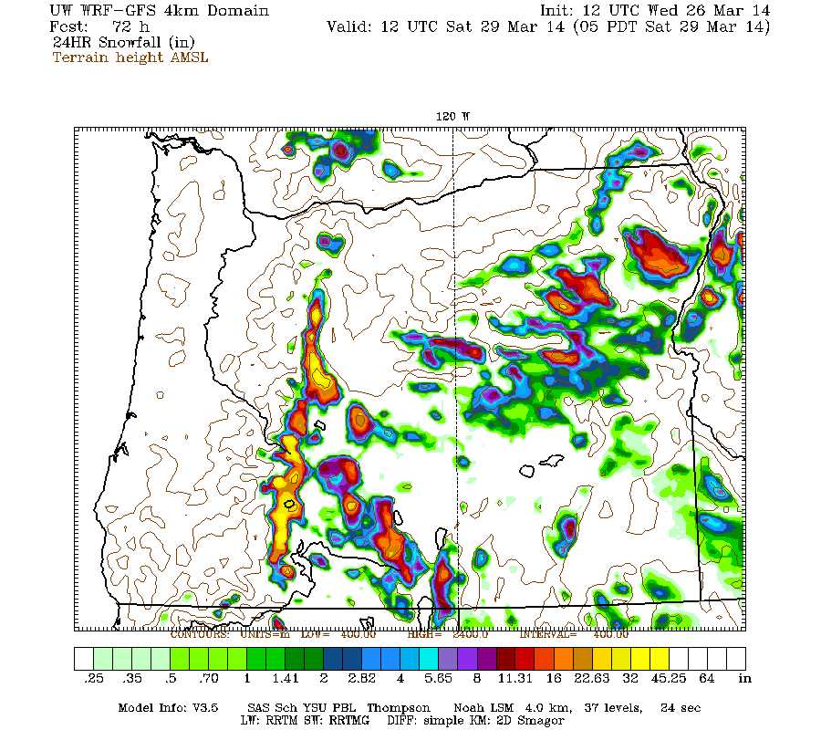
The 24-hour amounts during the later system through 5am Saturday are predicted to top 3 ft on many of the volcanoes, but snowfall will not extend down to low elevations and will be primarily above 5-6000 ft:
This extremely heavy snowfall coupled with higher snow levels is because the second system will include a moisture plume from a moderately-strong, moderately-warm atmospheric river aimed at southern Oregon and northern California. But this one is not nearly as strong, wet, or warm as the other earlier atmospheric river events which were part of the February 6-25 or February 26-March 10 storm cycles, which had snow levels exceeding 8-9000 ft at times. Here is the predicted moisture plume at its peak on Friday afternoon, showing that it originates in the subtropics around 28-30° N latitude, well north of Hawaii (located just off the lower left corner of the image) rather than in the tropics near Hawaii at 20° N like those earlier atmospheric river events:
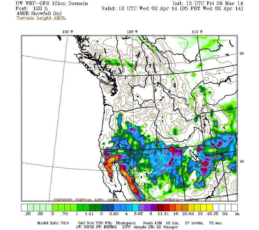
More storm systems are expected to arrive every 1-2 days after that through the weekend and into next week. Additional snowfall during the subsequent 3 days ending 5am next Tuesday (April 1) is predicted to be 2-5 ft over the Sierra Nevada, Trinity Alps, and California Cascades, with 1-2 ft extending north through Oregon and Washington into southwestern BC:
The D(model)/D(t) for that 3-day period has also been fairly consistent thus far, with amounts increasing a bit in California on more recent runs, although there have been only 4 model runs so far extending out to that period:
www.atmos.washington.edu/~ovens/wxloop.c...2+v2014040112///+-st
Another system next Tuesday may bring another shot of heavy snowfall primarily to California, with up to 1 ft there and much lighter amounts extending north through Oregon into Washington during the 24-hour period ending at 5am next Wednesday:
Details of that period will continue to change as it draws closer, as it is still 6-7 days out, near the limit of accurate numerical weather prediction. Especially so given that the evolution of the several storm systems prior to the weekend will have a significant effect on the development of the subsequent systems, and on upcoming model predictions.
What about the longer term? A definite end to this storm cycle is still not yet in sight. The extended GFS model out to 384 hours (16 days) shows additional storm systems throughout the 8-16 day period, although it is best to ignore specific details and amounts that far out. Nevertheless, it currently shows a lull next Wednesday and then another system affecting much of the West Coast on Thursday, April 3, followed by additional systems every 1-3 days through Friday April 11. This is the predicted 24-hour precip, click "Loop All" to see all the graphics (3 hour intervals up to 192 hours, 12 hour intervals beyond that):
GFS, North Pacific, 03/26/2014 12UTC, precip_p24
It certainly looks like a very stormy and snowy pattern extending well into April!
Update #1: 24 hours after initial post, up to 1 ft of new snow has already fallen from southwestern BC to northern California,
with an additional 4-10 ft (perhaps more) still predicted over that region during the rest of March and into early April!
This major spring storm cycle is now well underway as of midday Wednesday, with new snowfall of a few inches to over 1 ft during the past 36 hours since midnight Monday-Tuesday extending from the central BC Coast Mountains near Smithers all the way to the southern end of the Sierra Nevada, a distance of over 1400 miles as the crow flies. Maximum 24-hour amounts reported as of Wednesday morning include 14" new at Whistler Mountain, 13" at Buckinghorse SNOTEL in the Olympics, 12" at Mount Baker Ski Area, and 10" at the summit of the Kirkwood, Sierra-at-Tahoe, and Mammoth Mountain ski areas in California. Not a very strong or very wet first system, but a very large one as seen in this visible satellite image from 4pm PDT Monday while the system was still off the West Coast:
Quite interestingly, there were actually two low-pressure centers (one west of Oregon, the other west of the central BC coast) rotating about each other like a spinning dumbbell, see this animation of all Monday and Tuesday visible satellite images:
www.atmos.washington.edu/~ovens/wxloop.c...4032602+interval+30m
Model predictions continue on track with very heavy precip and snowfall expected over much of the West Coast during the next 7 days and beyond. The NWS's GFS model and their Quantitative Precipitation Forecasts are showing up to 6-10" of additional precip over the next week for the mountains of Washington, Oregon, and northern California, with 3-5" extending north into southwestern BC. Here is total precipitation in inches predicted over the next 7 days through the afternoon of Wednesday, April 2:
A day later, and 2 subsequent runs of the high-resolution UW WRF-GFS model at 12-hour intervals continue to predict large snowfall amounts up to 4-8 ft or more over the next week for the mountains of southwestern BC, Washington, Oregon, and northern California. Snowfall during the next 3 days from this morning through 5am Saturday is predicted to be 2-6 ft over the Oregon Cascades, California Cascades, Trinity Alps, and northern Sierra Nevada, with 1-3 ft for southwestern BC, the Olympics, and Washington Cascades:
This loop shows how the model predictions for snowfall during the 3-day period through 5am Saturday have evolved between 10 subsequent runs over the last 5 days, the D(model)/D(t). Very consistent in the overall picture throughout all those runs, with only minor variations in amounts -- so these model predictions are very likely to actually happen:
www.atmos.washington.edu/~ovens/wxloop.c...2+v2014032912///+-st
Higher resolution version of that, showing the Pacific Northwest and also zoomed in on Washington and Oregon:
Maximum amounts of 4-6 ft (marked by white inside yellow) are shown on Mount Rainier, Mount Saint Helens, almost the entire Cascade Range in Oregon (above the 1600 m / 5300 ft contour), Mount Shasta, and Lassen Peak. In Oregon, this is by far the largest area with predicted 3-day amounts over 4 ft shown in any graphic in any of the 5 storm cycle threads thus far. If the model prediction verifies, this will be the largest 3-day snowfall in the central and southern Oregon Cascades of the entire 2013-14 season thus far. Even Newberry Volcano and Yamsay Mountain (another large shield volcano east of Crater Lake, the highest volcano in the eastern Cascade chain at 8196 ft) are shown with 3 ft of snowfall expected, unusual given that both are 30 miles east of the Cascade Crest and normally quite rain-shadowed! Some major volcanoes have been labeled on the last graphic for clarity.
The extremely heavy snowfall in Oregon will occur during two separate systems, one from today into Thursday, and the other on Friday into Saturday. The 24-hour amounts during the first system through 5pm Thursday are predicted to top 2 ft on many of the volcanoes, with snowfall extending down to quite low elevations (3-4000 ft) for this time of year in that region:
The 24-hour amounts during the later system through 5am Saturday are predicted to top 3 ft on many of the volcanoes, but snowfall will not extend down to low elevations and will be primarily above 5-6000 ft:
This extremely heavy snowfall coupled with higher snow levels is because the second system will include a moisture plume from a moderately-strong, moderately-warm atmospheric river aimed at southern Oregon and northern California. But this one is not nearly as strong, wet, or warm as the other earlier atmospheric river events which were part of the February 6-25 or February 26-March 10 storm cycles, which had snow levels exceeding 8-9000 ft at times. Here is the predicted moisture plume at its peak on Friday afternoon, showing that it originates in the subtropics around 28-30° N latitude, well north of Hawaii (located just off the lower left corner of the image) rather than in the tropics near Hawaii at 20° N like those earlier atmospheric river events:
More storm systems are expected to arrive every 1-2 days after that through the weekend and into next week. Additional snowfall during the subsequent 3 days ending 5am next Tuesday (April 1) is predicted to be 2-5 ft over the Sierra Nevada, Trinity Alps, and California Cascades, with 1-2 ft extending north through Oregon and Washington into southwestern BC:
The D(model)/D(t) for that 3-day period has also been fairly consistent thus far, with amounts increasing a bit in California on more recent runs, although there have been only 4 model runs so far extending out to that period:
www.atmos.washington.edu/~ovens/wxloop.c...2+v2014040112///+-st
Another system next Tuesday may bring another shot of heavy snowfall primarily to California, with up to 1 ft there and much lighter amounts extending north through Oregon into Washington during the 24-hour period ending at 5am next Wednesday:
Details of that period will continue to change as it draws closer, as it is still 6-7 days out, near the limit of accurate numerical weather prediction. Especially so given that the evolution of the several storm systems prior to the weekend will have a significant effect on the development of the subsequent systems, and on upcoming model predictions.
What about the longer term? A definite end to this storm cycle is still not yet in sight. The extended GFS model out to 384 hours (16 days) shows additional storm systems throughout the 8-16 day period, although it is best to ignore specific details and amounts that far out. Nevertheless, it currently shows a lull next Wednesday and then another system affecting much of the West Coast on Thursday, April 3, followed by additional systems every 1-3 days through Friday April 11. This is the predicted 24-hour precip, click "Loop All" to see all the graphics (3 hour intervals up to 192 hours, 12 hour intervals beyond that):
GFS, North Pacific, 03/26/2014 12UTC, precip_p24
It certainly looks like a very stormy and snowy pattern extending well into April!
Please Log in or Create an account to join the conversation.
- Amar Andalkar
-
Topic Author
- User
-
Less
More
- Posts: 635
- Thank you received: 0
12 years 2 months ago #221613
by Amar Andalkar
Replied by Amar Andalkar on topic Re: Spring storm cycle, 4-10 ft snow Mar25-Apr7,2014!
[size=small]Almost went to Crystal today, but bailed after the last minute -- turned around just after leaving home, due to minimal new snow, expected whiteout, and other factors, I just didn't think it was worth burning that much gas -- hope I didn't miss anything too good up there. Spent the morning doing some PHP programming instead, but might as well write and post an update now, as this storm cycle remains very interesting!:[/size]
Update #2: 48 hours after initial post, up to 1-2 ft of new snow has already fallen from southwestern BC to northern California,
with an additional 4-8 ft (perhaps more) still predicted over that region during the rest of March and into early April!
The ongoing spring storm cycle is proceeding largely as expected, with the heaviest snowfall of 1 ft or greater during the second system from Wednesday through Thursday shifting south into southernmost Washington, Oregon, and California, but lighter amounts of a few inches still extending all the way north to the central BC coast. Maximum 30-hour new snow amounts through midday Thursday include 16" at Swift Creek SNOTEL (4440 ft) and 15" at June Lake SNOTEL (only 3440 ft!) on Mount Saint Helens, 18" at Timberline and 16" at Mount Hood Meadows, 11" at Mount Bachelor, 9" at Crater Lake, and 15" atop Sugar Bowl, 13" atop Squaw Valley, and 10" atop Mammoth Mountain in California. Heavy snowfall continues in southern Washington and Oregon on Thursday, but has tapered off in California.
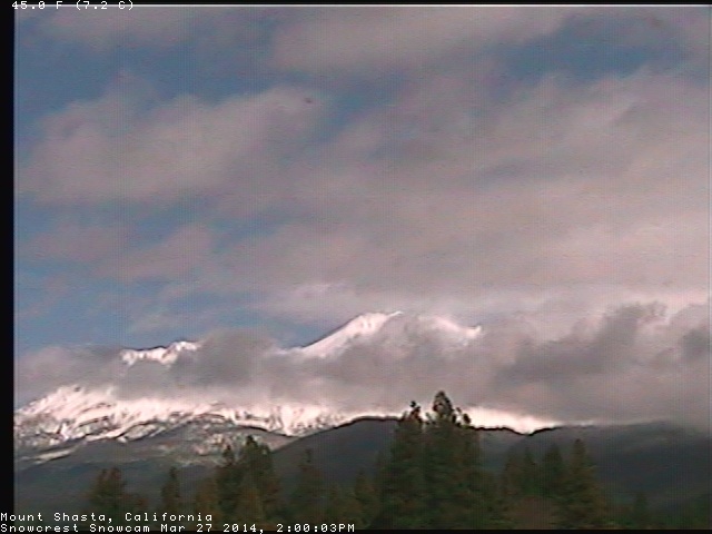
[size=small]Mount Shasta trying to clear out between storm systems on Thursday afternoon, as seen on the SnowCrest webcam .[/size]
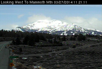
[size=small]Mammoth Mountain clears briefly between storm systems on Thursday morning after 15-20" of new snow the past 2 days, as seen on the Caltrans webcam .[/size]
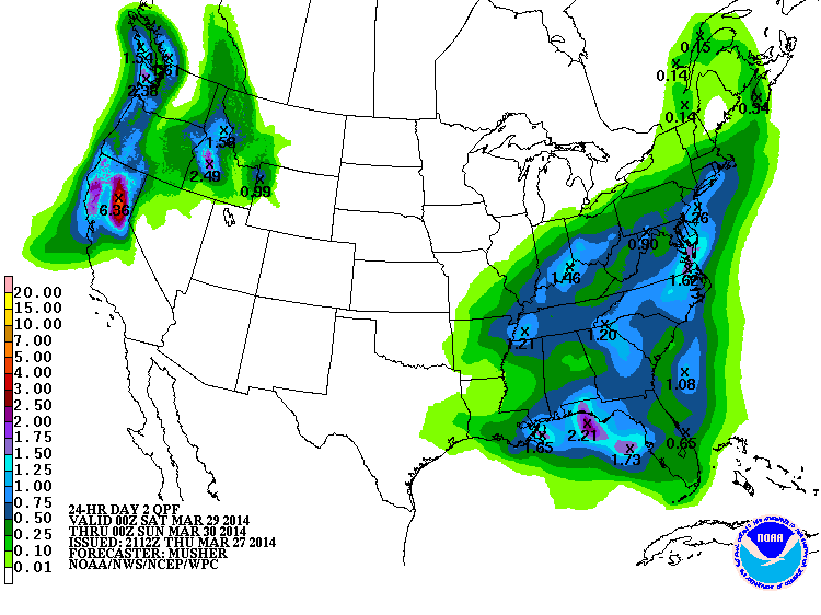
Model predictions continue on track with very heavy precip and snowfall expected over much of the West Coast during the next 7 days and beyond. The NWS's GFS model and their Quantitative Precipitation Forecasts are showing up to 6-9" of additional precip over the next week for the mountains of Washington, Oregon, and northern California, with 3-5" extending north into southwestern BC. Here is total precipitation in inches predicted over the next 7 days through the afternoon of Thursday, April 3:
The precip during a single 24-hour period from Friday to Saturday afternoon may exceed 5-6" in the California Cascades, courtesy of the moderately-strong atmospheric river detailed in the previous update above, with the bullseye here shown on Lassen Peak:
Another day later, and 2 subsequent runs of the high-resolution UW WRF-GFS model at 12-hour intervals continue to predict large snowfall amounts up to 4-8 ft or more over the next week for the mountains of southwestern BC, Washington, Oregon, and northern California. The strongest and wettest system of this storm cycle thus far will arrive early on Friday and extend through Saturday, bringing heavy precip and snowfall over the entire region. Snowfall during the next 3 days from this morning through 5am Sunday is predicted to be 2-5 ft from southwestern BC through the entire length of the Cascade Range and into the southern Sierra Nevada, a span of over 1000 miles:
Higher resolution version of that, showing the Pacific Northwest and also zoomed in on Washington and Oregon:
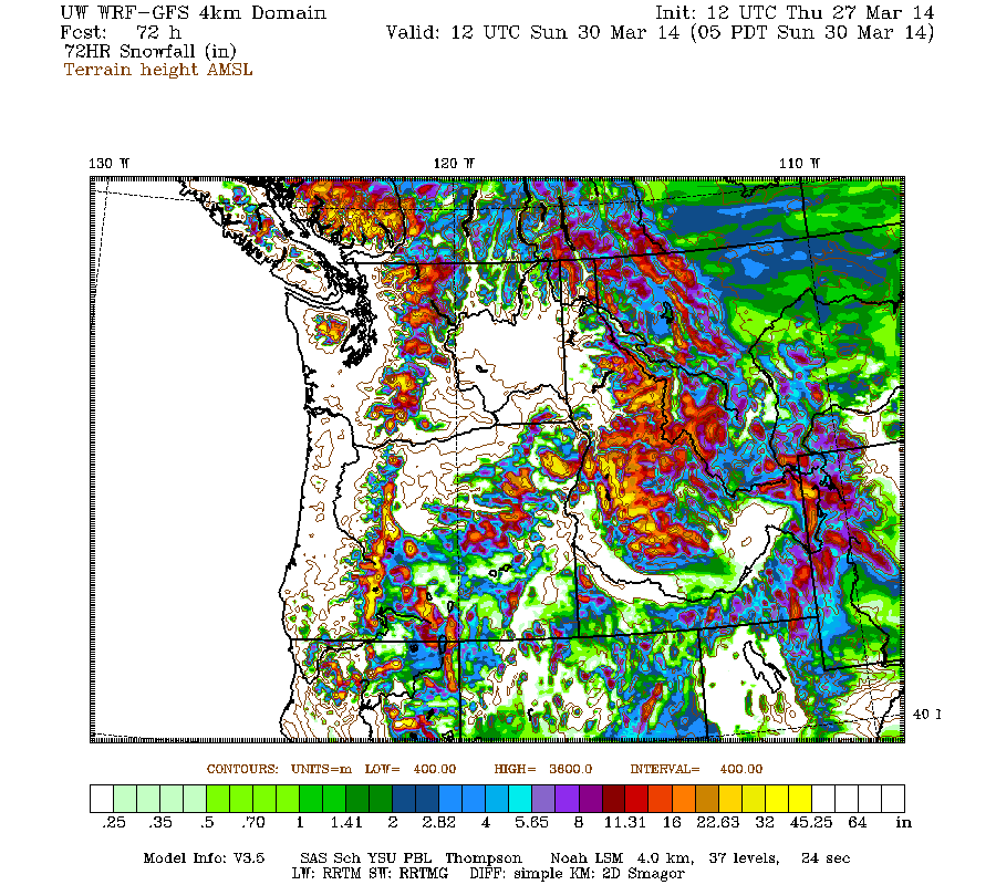
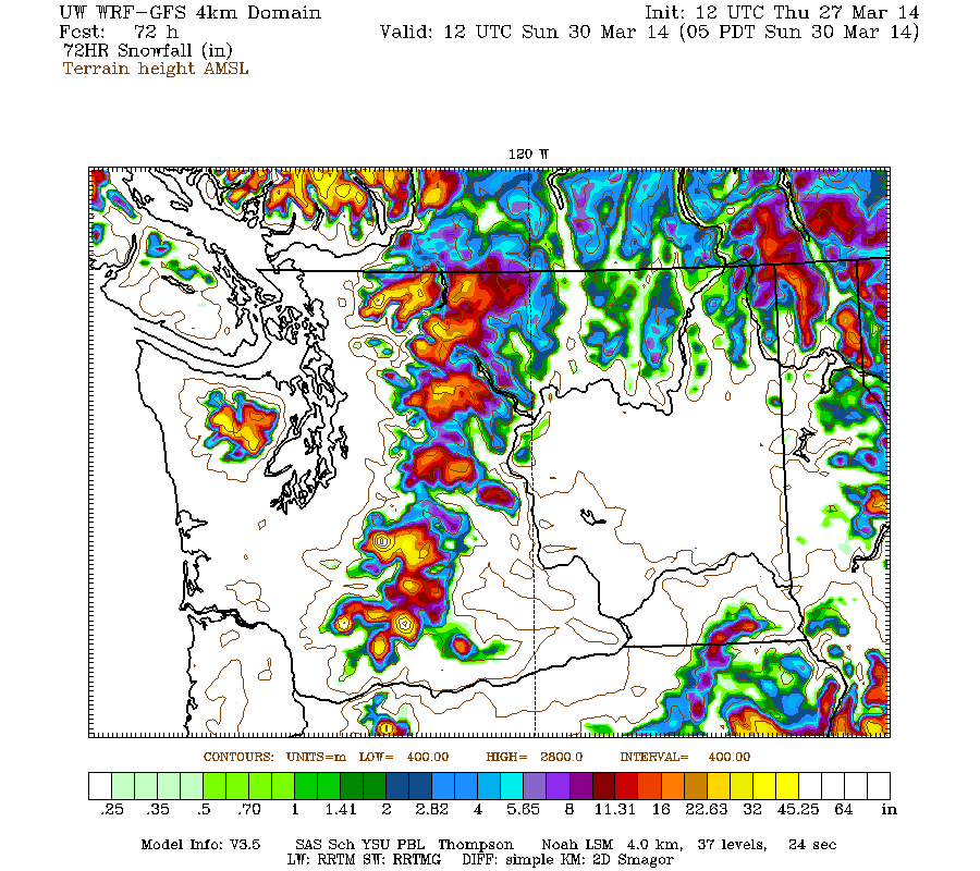
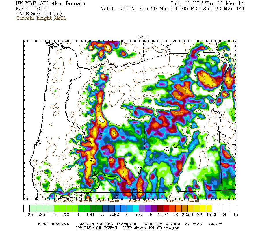
Maximum amounts of 4-5 ft (marked by white inside yellow) are shown on Mounts Baker, Rainier, Adams, and Saint Helens in Washington, on Mounts Hood, Jefferson, Bachelor, the Three Sisters, and Diamond Peak in Oregon, and in California on Mount Shasta, Lassen Peak, and even the massive shield of Medicine Lake Volcano, an unusually high amount since it's located 30 miles ENE of Shasta and normally quite rain-shadowed. It's hard to see the amounts for the California Cascades since there is no zoomed graphic available from the UW model, but I'm simply using a magnifying lens app on my computer to zoom in on the full 4km-domain graphic.
This loop shows how the model predictions for snowfall during the 3-day period through 5am Sunday have evolved between 10 subsequent runs over the last 5 days, the D(model)/D(t). Very consistent in the overall picture throughout all those runs, although with larger run-to-run variation in the oldest runs, then settling down over the most recent ones:
www.atmos.washington.edu/~ovens/wxloop.c...2+v2014033012///+-st
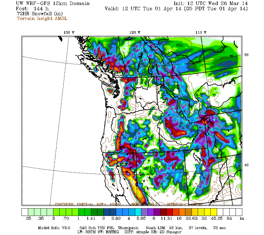
Another weaker system is expected on Sunday, followed by another stronger system on Monday aimed primarily at Oregon and California again. Additional snowfall during the subsequent 3 days ending 5am next Wednesday (April 2) is predicted to be 2-4 ft over the Sierra Nevada, Klamath Mountains, and California Cascades, with 1-2 ft extending north through Oregon and Washington into southwestern BC:
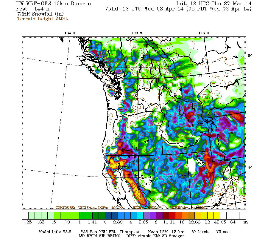
The D(model)/D(t) for that 3-day period has also been fairly consistent thus far, with amounts increasing a bit in California on more recent runs, although there have been only 4 model runs so far extending out to that period:
www.atmos.washington.edu/~ovens/wxloop.c...2+v2014040212///+-st
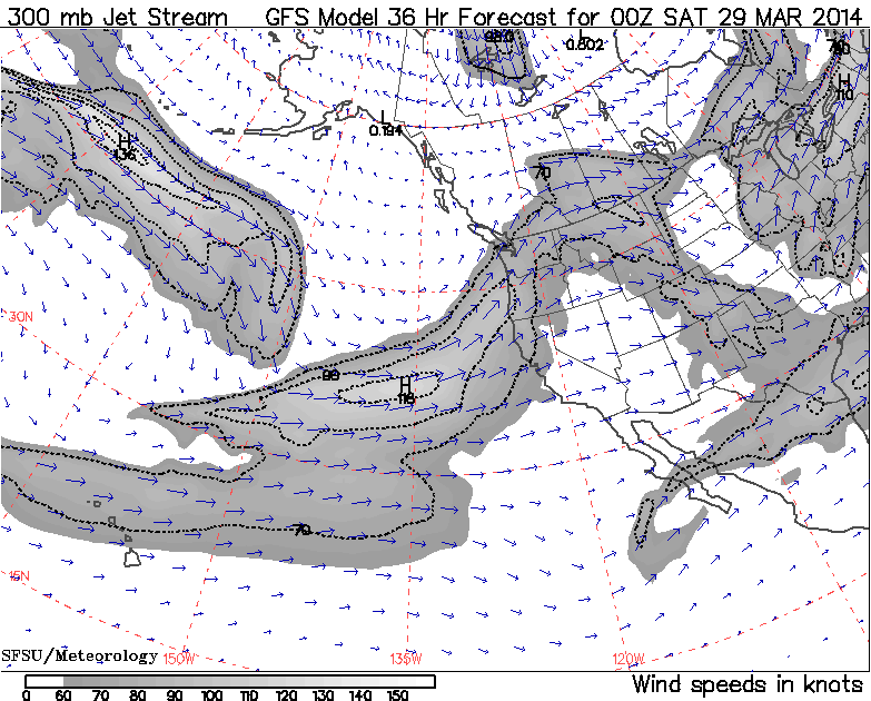
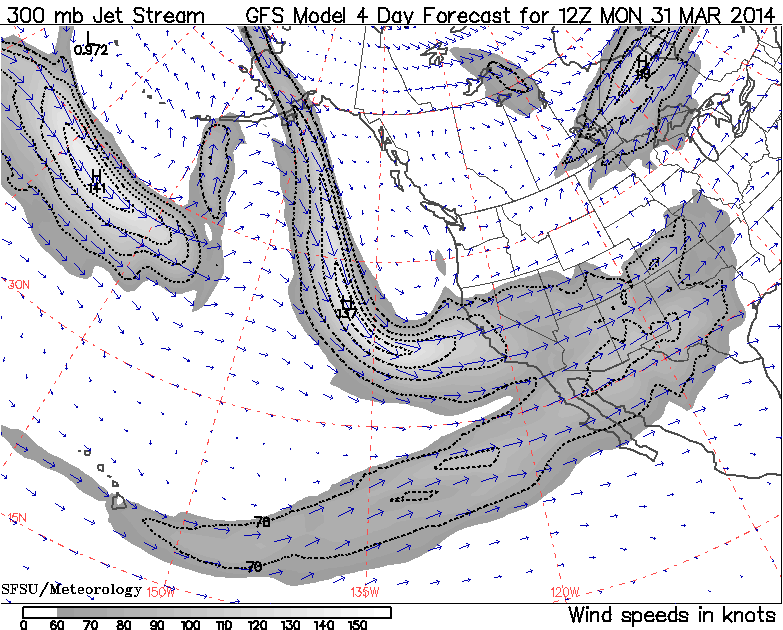
The strong system on Monday is expected to be quite different from the one on Friday, with much lower snow levels due to northwesterly and westerly flow over the Pacific, as seen in the jet stream forecasts . Here is the predicted jet stream at 5pm PDT Friday, with primarily southwesterly flow associated with the atmospheric river, and then at 5am PDT Monday, showing the complete change in configuration and direction over that period:
After a lull on Wednesday, another system is still predicted by Thursday, with significant snowfall increasing during the 24-hour period ending at 5pm next Thursday, April 3 (and expected to continue through Friday):
And there's still no definite end to this storm cycle in sight as of yet, as the extended GFS model out to 384 hours (16 days) continues to show additional storm systems throughout the 8-16 day period, although it is best to ignore specific details and amounts that far out. This is the predicted 24-hour precip, click "Loop All" to see all the graphics (3 hour intervals up to 192 hours, 12 hour intervals beyond that):
GFS, North Pacific, 03/27/2014 12UTC, precip_p24
Still on course for a very snowy start to April!
Update #2: 48 hours after initial post, up to 1-2 ft of new snow has already fallen from southwestern BC to northern California,
with an additional 4-8 ft (perhaps more) still predicted over that region during the rest of March and into early April!
The ongoing spring storm cycle is proceeding largely as expected, with the heaviest snowfall of 1 ft or greater during the second system from Wednesday through Thursday shifting south into southernmost Washington, Oregon, and California, but lighter amounts of a few inches still extending all the way north to the central BC coast. Maximum 30-hour new snow amounts through midday Thursday include 16" at Swift Creek SNOTEL (4440 ft) and 15" at June Lake SNOTEL (only 3440 ft!) on Mount Saint Helens, 18" at Timberline and 16" at Mount Hood Meadows, 11" at Mount Bachelor, 9" at Crater Lake, and 15" atop Sugar Bowl, 13" atop Squaw Valley, and 10" atop Mammoth Mountain in California. Heavy snowfall continues in southern Washington and Oregon on Thursday, but has tapered off in California.
[size=small]Mount Shasta trying to clear out between storm systems on Thursday afternoon, as seen on the SnowCrest webcam .[/size]
[size=small]Mammoth Mountain clears briefly between storm systems on Thursday morning after 15-20" of new snow the past 2 days, as seen on the Caltrans webcam .[/size]
Model predictions continue on track with very heavy precip and snowfall expected over much of the West Coast during the next 7 days and beyond. The NWS's GFS model and their Quantitative Precipitation Forecasts are showing up to 6-9" of additional precip over the next week for the mountains of Washington, Oregon, and northern California, with 3-5" extending north into southwestern BC. Here is total precipitation in inches predicted over the next 7 days through the afternoon of Thursday, April 3:
The precip during a single 24-hour period from Friday to Saturday afternoon may exceed 5-6" in the California Cascades, courtesy of the moderately-strong atmospheric river detailed in the previous update above, with the bullseye here shown on Lassen Peak:
Another day later, and 2 subsequent runs of the high-resolution UW WRF-GFS model at 12-hour intervals continue to predict large snowfall amounts up to 4-8 ft or more over the next week for the mountains of southwestern BC, Washington, Oregon, and northern California. The strongest and wettest system of this storm cycle thus far will arrive early on Friday and extend through Saturday, bringing heavy precip and snowfall over the entire region. Snowfall during the next 3 days from this morning through 5am Sunday is predicted to be 2-5 ft from southwestern BC through the entire length of the Cascade Range and into the southern Sierra Nevada, a span of over 1000 miles:
Higher resolution version of that, showing the Pacific Northwest and also zoomed in on Washington and Oregon:
Maximum amounts of 4-5 ft (marked by white inside yellow) are shown on Mounts Baker, Rainier, Adams, and Saint Helens in Washington, on Mounts Hood, Jefferson, Bachelor, the Three Sisters, and Diamond Peak in Oregon, and in California on Mount Shasta, Lassen Peak, and even the massive shield of Medicine Lake Volcano, an unusually high amount since it's located 30 miles ENE of Shasta and normally quite rain-shadowed. It's hard to see the amounts for the California Cascades since there is no zoomed graphic available from the UW model, but I'm simply using a magnifying lens app on my computer to zoom in on the full 4km-domain graphic.
This loop shows how the model predictions for snowfall during the 3-day period through 5am Sunday have evolved between 10 subsequent runs over the last 5 days, the D(model)/D(t). Very consistent in the overall picture throughout all those runs, although with larger run-to-run variation in the oldest runs, then settling down over the most recent ones:
www.atmos.washington.edu/~ovens/wxloop.c...2+v2014033012///+-st
Another weaker system is expected on Sunday, followed by another stronger system on Monday aimed primarily at Oregon and California again. Additional snowfall during the subsequent 3 days ending 5am next Wednesday (April 2) is predicted to be 2-4 ft over the Sierra Nevada, Klamath Mountains, and California Cascades, with 1-2 ft extending north through Oregon and Washington into southwestern BC:
The D(model)/D(t) for that 3-day period has also been fairly consistent thus far, with amounts increasing a bit in California on more recent runs, although there have been only 4 model runs so far extending out to that period:
www.atmos.washington.edu/~ovens/wxloop.c...2+v2014040212///+-st
The strong system on Monday is expected to be quite different from the one on Friday, with much lower snow levels due to northwesterly and westerly flow over the Pacific, as seen in the jet stream forecasts . Here is the predicted jet stream at 5pm PDT Friday, with primarily southwesterly flow associated with the atmospheric river, and then at 5am PDT Monday, showing the complete change in configuration and direction over that period:
After a lull on Wednesday, another system is still predicted by Thursday, with significant snowfall increasing during the 24-hour period ending at 5pm next Thursday, April 3 (and expected to continue through Friday):
And there's still no definite end to this storm cycle in sight as of yet, as the extended GFS model out to 384 hours (16 days) continues to show additional storm systems throughout the 8-16 day period, although it is best to ignore specific details and amounts that far out. This is the predicted 24-hour precip, click "Loop All" to see all the graphics (3 hour intervals up to 192 hours, 12 hour intervals beyond that):
GFS, North Pacific, 03/27/2014 12UTC, precip_p24
Still on course for a very snowy start to April!
Please Log in or Create an account to join the conversation.
- Amar Andalkar
-
Topic Author
- User
-
Less
More
- Posts: 635
- Thank you received: 0
12 years 2 months ago - 12 years 2 months ago #221621
by Amar Andalkar
Replied by Amar Andalkar on topic Re: Spring storm cycle, 4-10 ft snow Mar25-Apr7,2014!
Update #3: 72 hours after initial post, up to 1-3 ft of new snow has already fallen from southwestern BC to northern California,
with an additional 4-8 ft (perhaps more) still predicted over that region during the rest of March and into early April!
Snowfall from the second system of this spring storm cycle continued through Thursday, heaviest over Oregon with maximum 24-hour new snow amounts through day's end near 1 ft on Mount Hood, but once again with light amounts extending over a vast region of over 1400 miles from the central BC Coast Mountains near Smithers all the way to the southern end of the Sierra Nevada past Mammoth Mountain. The next much stronger system has already reached the coast early on Friday, with heavy precip and snowfall spreading first over southwestern BC, Washington, and Oregon, and later into northern California. This system and its heavy post-frontal snow showers are expected to extend through Saturday, with another round of lighter snow showers on Sunday.
The greatest total snowfall amounts for this storm-cycle thus far through midday Friday are 36" at Timberline Lodge and 31" at Mount Hood Meadows, increasing the snowdepth from 135" to 160" at Timberline and 107" to 131" at Meadows since Tuesday morning. These sites are now once again reaching 100% of normal snowdepth for the first time in over a month since the huge February storm cycle ended. Total precip thus far has been over 5" at Timberline and 4" at Meadows, and also over 5" at both Swift Creek SNOTEL (4440 ft) and June Lake SNOTEL (3440 ft) on Mount Saint Helens, and at Bear Grass SNOTEL (4720 ft) west of Mount Washington in Oregon, with snowfall of about 2.5 ft at Bear Grass and Swift Creek but only about 1.5 ft at June Lake due to the lower elevation.
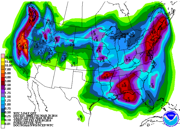
Model predictions continue on track with very heavy precip and snowfall expected over much of the West Coast during at least the next 8 days through Saturday, April 5, and perhaps beyond. The NWS's GFS model and their Quantitative Precipitation Forecasts are showing up to 6-10" of additional precip over the next week for the mountains of Washington, Oregon, and northern California, with 3-5" extending north into southwestern BC. Here is total precipitation in inches predicted over the next 7 days through the morning of Friday, April 4:
Another day later, and 2 subsequent runs of the high-resolution UW WRF-GFS model at 12-hour intervals continue to predict large snowfall amounts up to 4-8 ft or more over the next week for the mountains of southwestern BC, Washington, Oregon, and northern California. Snowfall during the next 3 days from this morning through 5am Monday is predicted to be 2-5 ft from southwestern BC through the entire length of the Cascade Range and into the central Sierra Nevada, a span of about 1000 miles:
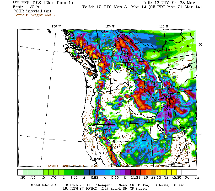
Higher resolution version of that, showing the Pacific Northwest and also zoomed in on Washington and Oregon:
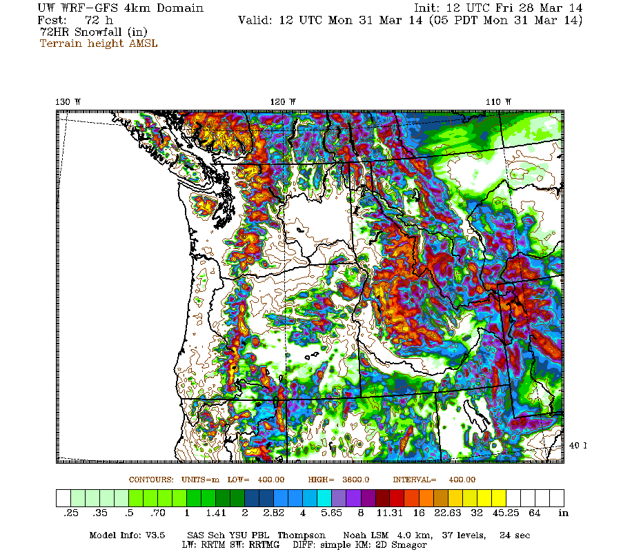
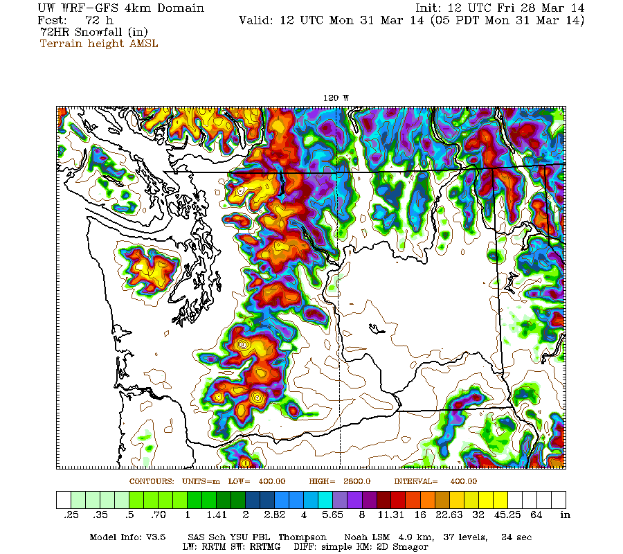
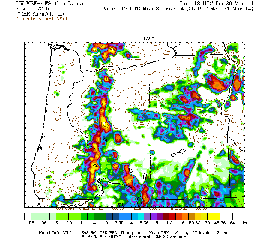
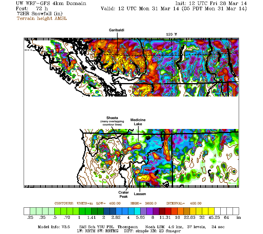
Maximum amounts of 4-5 ft (marked by white inside yellow) are shown on Mount Garibaldi in BC, Mounts Olympus, Baker, Rainier, Adams, and Saint Helens in Washington, the Three Sisters in Oregon, and Mount Shasta, Crater Peak (an 8677 ft stratovolcano north of Lassen), and Lassen Peak in California. It's hard to see the highest amounts for southwestern BC or the California Cascades since there is no zoomed graphic available for those areas from the UW model, but I'm simply using a magnifying lens app on my computer to zoom in on the full 4km-domain graphic. Just for fun, I decided to try making a crudely-magnified version of the 4km graphic for southwestern BC and the California Cascades in Photoshop, and it only took several minutes to finish. Here it is with x2 magnification of those areas and several major volcanoes labeled for clarity:
This loop shows how the model predictions for snowfall during the 3-day period through 5am Monday have evolved between 10 subsequent runs over the last 5 days, the D(model)/D(t). Very consistent in the overall picture throughout all those runs, although with larger run-to-run variation in the oldest runs, then settling down over the most recent ones:
www.atmos.washington.edu/~ovens/wxloop.c...2+v2014033112///+-st
Another stronger system is expected to arrive on Monday morning through Tuesday aimed primarily at northern California again, with much lower snow levels as explained in Update #2 above. Additional snowfall during the 2-day period from 5am Monday to Wednesday is predicted to be 2-3 ft over the Sierra Nevada, Klamath Mountains, and California Cascades, with much lighter amounts less than 1 ft extending north through Oregon:
The D(model)/D(t) for that 2-day period has also been fairly consistent thus far, with amounts increasing a bit in California and decreasing farther north on more recent runs, although there have been only 6 model runs so far extending out to that period:
www.atmos.washington.edu/~ovens/wxloop.c...8+v2014040212///+-st
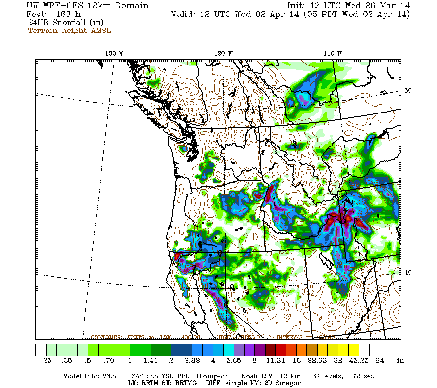
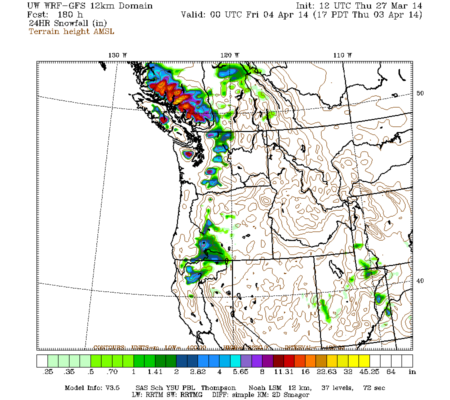
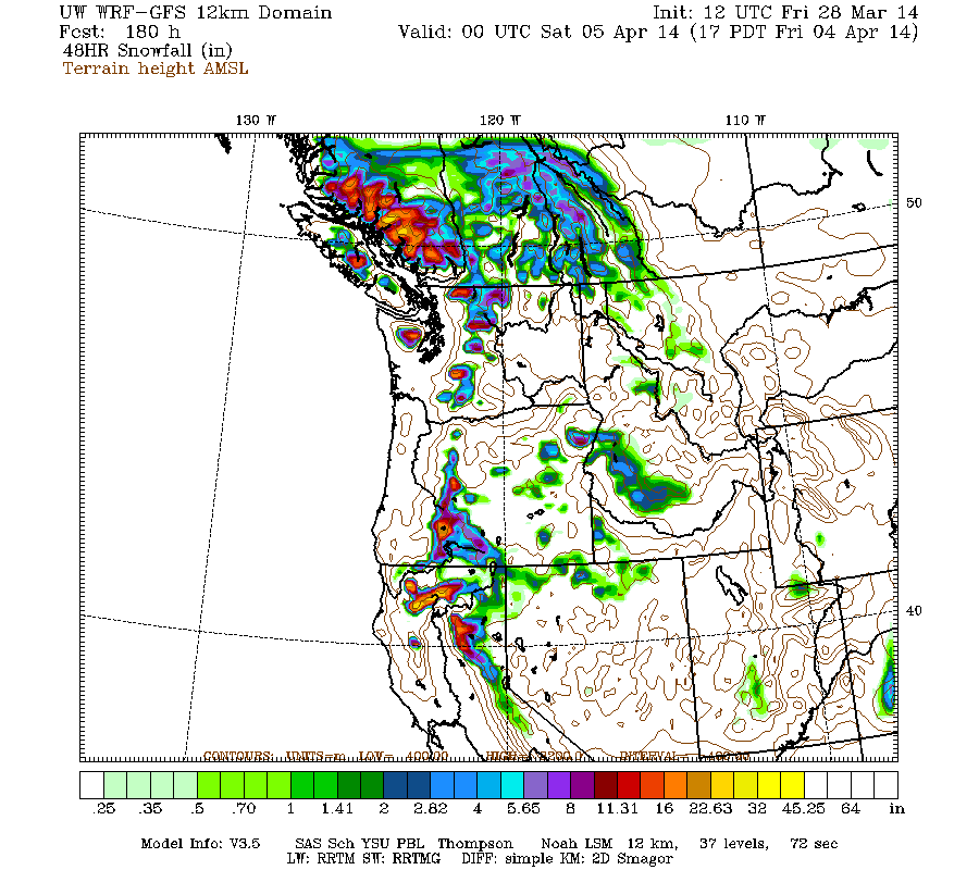
After a lull on Wednesday, another system is still predicted for Thursday through Friday, this time affecting the entire region from southwestern BC to northern California. Additional snowfall during the 2-day period through 5pm Friday April 4 is predicted to be 1-2 ft over that entire span, with greater amounts up to 2-3 ft in parts of southwestern BC, the California Cascades, and Klamath Mountains:
Still no definite end to this storm cycle in sight as of yet, as the extended GFS model out to 384 hours (16 days) continues to show additional storm systems throughout the 8-16 day period, although it is best to ignore specific details and amounts that far out. This is the predicted 24-hour precip, click "Loop All" to see all the graphics (3 hour intervals up to 192 hours, 12 hour intervals beyond that):
GFS, North Pacific, 03/28/2014 12UTC, precip_p24
Looking like a spectacular snowy finish for March and a super snowy start for April!
with an additional 4-8 ft (perhaps more) still predicted over that region during the rest of March and into early April!
Snowfall from the second system of this spring storm cycle continued through Thursday, heaviest over Oregon with maximum 24-hour new snow amounts through day's end near 1 ft on Mount Hood, but once again with light amounts extending over a vast region of over 1400 miles from the central BC Coast Mountains near Smithers all the way to the southern end of the Sierra Nevada past Mammoth Mountain. The next much stronger system has already reached the coast early on Friday, with heavy precip and snowfall spreading first over southwestern BC, Washington, and Oregon, and later into northern California. This system and its heavy post-frontal snow showers are expected to extend through Saturday, with another round of lighter snow showers on Sunday.
The greatest total snowfall amounts for this storm-cycle thus far through midday Friday are 36" at Timberline Lodge and 31" at Mount Hood Meadows, increasing the snowdepth from 135" to 160" at Timberline and 107" to 131" at Meadows since Tuesday morning. These sites are now once again reaching 100% of normal snowdepth for the first time in over a month since the huge February storm cycle ended. Total precip thus far has been over 5" at Timberline and 4" at Meadows, and also over 5" at both Swift Creek SNOTEL (4440 ft) and June Lake SNOTEL (3440 ft) on Mount Saint Helens, and at Bear Grass SNOTEL (4720 ft) west of Mount Washington in Oregon, with snowfall of about 2.5 ft at Bear Grass and Swift Creek but only about 1.5 ft at June Lake due to the lower elevation.
Model predictions continue on track with very heavy precip and snowfall expected over much of the West Coast during at least the next 8 days through Saturday, April 5, and perhaps beyond. The NWS's GFS model and their Quantitative Precipitation Forecasts are showing up to 6-10" of additional precip over the next week for the mountains of Washington, Oregon, and northern California, with 3-5" extending north into southwestern BC. Here is total precipitation in inches predicted over the next 7 days through the morning of Friday, April 4:
Another day later, and 2 subsequent runs of the high-resolution UW WRF-GFS model at 12-hour intervals continue to predict large snowfall amounts up to 4-8 ft or more over the next week for the mountains of southwestern BC, Washington, Oregon, and northern California. Snowfall during the next 3 days from this morning through 5am Monday is predicted to be 2-5 ft from southwestern BC through the entire length of the Cascade Range and into the central Sierra Nevada, a span of about 1000 miles:
Higher resolution version of that, showing the Pacific Northwest and also zoomed in on Washington and Oregon:
Maximum amounts of 4-5 ft (marked by white inside yellow) are shown on Mount Garibaldi in BC, Mounts Olympus, Baker, Rainier, Adams, and Saint Helens in Washington, the Three Sisters in Oregon, and Mount Shasta, Crater Peak (an 8677 ft stratovolcano north of Lassen), and Lassen Peak in California. It's hard to see the highest amounts for southwestern BC or the California Cascades since there is no zoomed graphic available for those areas from the UW model, but I'm simply using a magnifying lens app on my computer to zoom in on the full 4km-domain graphic. Just for fun, I decided to try making a crudely-magnified version of the 4km graphic for southwestern BC and the California Cascades in Photoshop, and it only took several minutes to finish. Here it is with x2 magnification of those areas and several major volcanoes labeled for clarity:
This loop shows how the model predictions for snowfall during the 3-day period through 5am Monday have evolved between 10 subsequent runs over the last 5 days, the D(model)/D(t). Very consistent in the overall picture throughout all those runs, although with larger run-to-run variation in the oldest runs, then settling down over the most recent ones:
www.atmos.washington.edu/~ovens/wxloop.c...2+v2014033112///+-st
Another stronger system is expected to arrive on Monday morning through Tuesday aimed primarily at northern California again, with much lower snow levels as explained in Update #2 above. Additional snowfall during the 2-day period from 5am Monday to Wednesday is predicted to be 2-3 ft over the Sierra Nevada, Klamath Mountains, and California Cascades, with much lighter amounts less than 1 ft extending north through Oregon:
The D(model)/D(t) for that 2-day period has also been fairly consistent thus far, with amounts increasing a bit in California and decreasing farther north on more recent runs, although there have been only 6 model runs so far extending out to that period:
www.atmos.washington.edu/~ovens/wxloop.c...8+v2014040212///+-st
After a lull on Wednesday, another system is still predicted for Thursday through Friday, this time affecting the entire region from southwestern BC to northern California. Additional snowfall during the 2-day period through 5pm Friday April 4 is predicted to be 1-2 ft over that entire span, with greater amounts up to 2-3 ft in parts of southwestern BC, the California Cascades, and Klamath Mountains:
Still no definite end to this storm cycle in sight as of yet, as the extended GFS model out to 384 hours (16 days) continues to show additional storm systems throughout the 8-16 day period, although it is best to ignore specific details and amounts that far out. This is the predicted 24-hour precip, click "Loop All" to see all the graphics (3 hour intervals up to 192 hours, 12 hour intervals beyond that):
GFS, North Pacific, 03/28/2014 12UTC, precip_p24
Looking like a spectacular snowy finish for March and a super snowy start for April!
Please Log in or Create an account to join the conversation.
- filbo
-
- User
-
Less
More
- Posts: 184
- Thank you received: 0
12 years 2 months ago #221637
by filbo
Replied by filbo on topic Re: Spring storm cycle, 4-10 ft snow Mar25-Apr7,2014!
Thanks for all the stoke!
Please Log in or Create an account to join the conversation.
- timbat
-
- User
-
Less
More
- Posts: 6
- Thank you received: 0
12 years 2 months ago #221691
by timbat
Replied by timbat on topic Re: Spring storm cycle, 4-10 ft snow Mar25-Apr7,2014!
Hmmm .... did Utah steal all our new spring snow ?
Please Log in or Create an account to join the conversation.