- Posts: 158
- Thank you received: 0
Hiking loop ideas around alpine lakes? 20-30 miles
- samthaman
-
 Topic Author
- User
-

Less
More
13 years 10 months ago #206170
by samthaman
Hiking loop ideas around alpine lakes? 20-30 miles was created by samthaman
I figured I'd ask around to see if anyone had any ideas for loop hikes in the ALW. I'm new to the Seattle area and haven't had time to fine a lot of useful info yet. I figure I cant go too wrong in terrain like that, but if anyone has ideas for hikes they've really enjoyed, I'd love to hear them.
Please Log in or Create an account to join the conversation.
- James Wells
-
- User
-
Less
More
- Posts: 217
- Thank you received: 0
13 years 10 months ago #206171
by James Wells
Replied by James Wells on topic Re: Hiking loop ideas around alpine lakes? 20-30 miles
A pretty common loop (with easy car shuttle) is to go in via Aasgard Pass and then exit by Snow Creek. It's something like 21 miles and +6,000' or so.
I thought the exit was long, boring and stupid. By the end of it, we were wishing we had just gone back down Aasgard. So from a spectacular entry up Aasgard into the upper part of Alpine Lakes, hopefully there is some much better place to create a loop from.
I assume you know that to overnight in most of the area, you need a permit, and they can by hard to get. We did it in a day which was fine but limited the opportunity for side trips to any of the fantastic places you could see in all directions.
Please Log in or Create an account to join the conversation.
- Randito
-
- User
-
Less
More
- Posts: 960
- Thank you received: 1
13 years 10 months ago #206172
by Randito
Replied by Randito on topic Re: Hiking loop ideas around alpine lakes? 20-30 miles
Deception pass loop -- start at the end of the Cle Elum river road and hike to Tuck and Robin Lakes, then to Deception Pass and back on the PCT past Catheral Rock -- side trip to Peggy's Pond and/or Deep Lake.
Waptus Pass Loop -- Start at Salmon Le Sac campground head to Waptus Lake, up and over Waptus Pass, down to Pete Lake and back along the Cooper River trail. Longer variation of this would be to follow the PCT along Waptus Lake, up and over Escondito ridge -- either dropping down the Waptus Burn trail -- or continuing along the PCT to the Lemah ford and then back to Pete Lake.
If you are able to do some off trail traveling:
From Salmon Lec Sac head up the Waptus river trail, ford the Waptus river and head up Trail creek to Lake Michael and Lake Terrance -- then travel cross country to the top of Davis peak and descend the Davis Peak trail and Cle Elum river road back to Salmon Le Sac.
Take the PCT north from Snoqualmie Pass to Park Lakes, then travel cross country over "East Alta" to Lila Lakes basin, Rampart lakes and Lake Lillian -- A MTB stashed at the "backdoor" trailhead will get you back to Snoqualmie Pass.
Please Log in or Create an account to join the conversation.
- Mofro
-
- User
-
Less
More
- Posts: 170
- Thank you received: 0
13 years 10 months ago #206173
by Mofro
Replied by Mofro on topic Re: Hiking loop ideas around alpine lakes? 20-30 miles
Seconded on the Deception Pass loop, but with the following variation- first head up to Tuck and Robin ~ 8 miles. next head to Deception Pass and continue over to Marmot and Jade lakes ~(8 mi from Robin to Marmot, add another ~2 mi up a scramble to Jade but sooo worth it). Then head back out and follow the PCT to Cathedral Pass and stay at Peggy's Pond, ~10-12 mi from Marmot/Jade. It's an extra 3.5 miles of gentle switch backs down to Deep Lake, but after being at Robin and Jade, Deep was anti-climatic for me. Easy 4-5 mi out from Peggy's Pond back to the car. Can be done in either direction.
Robin from the top of Granite:
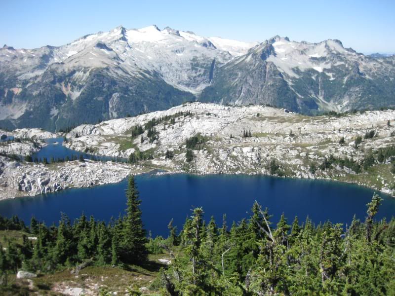
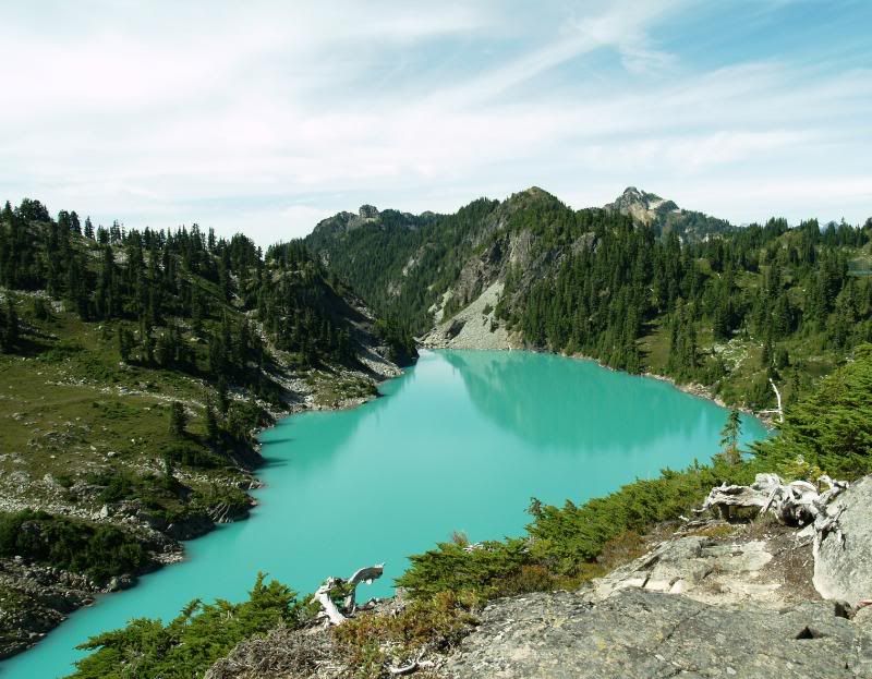
Looking down at Jade from the "Little Jade Glacier"
Robin from the top of Granite:
Looking down at Jade from the "Little Jade Glacier"
Please Log in or Create an account to join the conversation.
- normanclyde
-
- User
-
Less
More
- Posts: 28
- Thank you received: 0
13 years 10 months ago #206174
by normanclyde
Replied by normanclyde on topic Re: Hiking loop ideas around alpine lakes? 20-30 miles
There are a couple of options just off I-90 in the Alpental/Denny Creek area. You can more or less follow the Chair Peak Circumnav counterclockwise then continue down Denny Creek to the trailhead. This would involve either a car shuttle or a hike back to Alpental on pavement. There is a loop between Denny Creek and the Pratt Lakes Trailhead of Granite Mountain fame, 13.7 miles with a car shuttle, 16.7 without, that reaches Melakwa Lake then turns west. Mostly below alpine but with two nice opportunities for solitary lake swims which you would no doubt welcome in this weather. See Mike McQuade’s Trail Running Guide to Western Washington.
You can take the Gold Creek trail to the PCT, then return via the PCT to Snoqualmie. This also involves a car shuttle or road hike at the end. 20 plus miles.
If you’re willing to consider locations besides the Alpine Lakes, I can give you a couple of strong recommendations.
The Ipsut Creek/Spray Park loop (also in McQuade’s book) follows the Wonderland Trail to Carbon River, the alternative WT to Ipsut Pass, then returns to Mowich Lake via the Eunice Lakes trail. 16.6 miles, 4.5K elevation gain and loss.
The Loowit Trail around St. Helens is a legitimate adventure: 6K gain and loss in a loop of around 33 miles, nearly half of them off trail within the blast zone.
Two loops along the Wonderland Trail, entirely within MRNP, offer considerable challenge. Take the WT from the Fryingpan trailhead through Panhandle Gap, past Indian Bar along Cowlitz Divide, left on Olallie Creek Trail and descend to what I believe is called the East Side Trail, which parallels the Ohanapecosh River (and runs within earshot of the highway for several miles). Left at Needle Creek up the Owyhigh Lakes Trail which returns you to the White River Road a mile east of the Fryingpan trailhead. 30 something miles, 10K elevation gain and loss.
Better still, take the Wonderland from Carbon River to Berkeley Park, then return via the Northern Loop trail. This includes a stunning entry into Grand Park, the largest alpine meadow in MRNP, with whose springtime pleasures several TAYers are familiar but which is certainly worth a visit in summer, ideally just after snowmelt when the wildflowers are blooming (i.e. two to four weeks ago). 30 miles. About 10K elevation gain and loss. Unforgettable.
Please Log in or Create an account to join the conversation.
- mikerolfs
-
- User
-
Less
More
- Posts: 181
- Thank you received: 1
13 years 10 months ago #206175
by mikerolfs
Replied by mikerolfs on topic Re: Hiking loop ideas around alpine lakes? 20-30 miles
Not in ALW, but in the North Cascades Natl Park, I just did a one way from Hwy 20 to Stehekin that was really nice. Bridge Creek TH start, bakery at Stehekin and ferry boat ride to finish. Really nice area and recently maintained trails by the Student Conservation Association. I was on the trail as an approach to a mountain adventure, but it was so nice it would be worth the walk just for the walk.
Not ski related, but here is my trip report:
www.wenatcheeoutdoorsforum.org/showthrea...E-Buttress-7-26-2012
Not ski related, but here is my trip report:
www.wenatcheeoutdoorsforum.org/showthrea...E-Buttress-7-26-2012
Please Log in or Create an account to join the conversation.