- Posts: 635
- Thank you received: 0
Mount Rainier Rescue..>5-10-11
- Amar Andalkar
-

- User
-

Less
More
15 years 1 week ago #200111
by Amar Andalkar
Replied by Amar Andalkar on topic Re: Mount Rainier Rescue..>5-10-11
Terrible news, condolences to Tucker's family and friends. Having skied the upper Nisqually numerous times (5 times since 2007, including a January and two May descents), this really hits home, since it could have easily been me taking that same fall.
I was skinning up the Muir Snowfield on May 10, and around 1pm the KING-5 helicopter began circling overhead and above the south side of the upper mountain. Feared the worst after the helicopter lingered and kept circling (not just a quick scenic flyby), which was confirmed when two climbing rangers passed me at 9800 ft at 1:45pm, skinning uphill at max speed. A brief chat as I struggled to keep pace with them confirmed that a body recovery mission was underway, with the park's helicopter being fueled at the Kautz helibase and then heading up to pick up the rangers at Muir.
It turns out that the party was skinning up, not skiing down. Much more new info in this article:
www.thenewstribune.com/2011/05/11/166178...n-mount-rainier.html
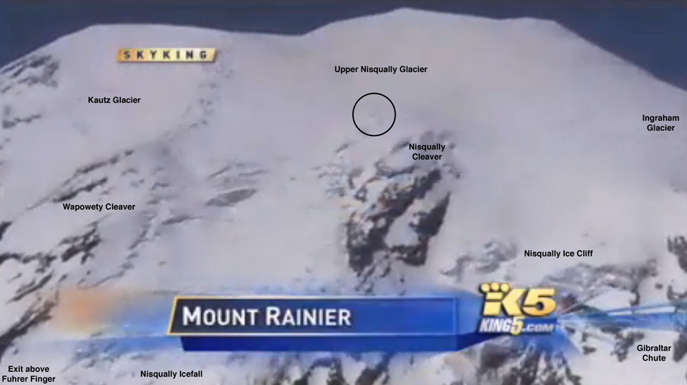
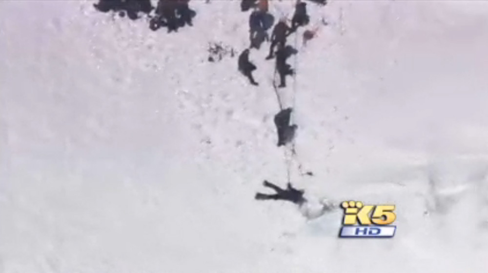
The accident site was just west of Nisqually Cleaver, see the images below. Hearsay at Camp Muir on May 10 was that the party had climbed Fuhrer Finger and that was presumably their intended ski descent too, but I have no idea if that info is correct.
However, it looks like a non-standard place for them to have been skinning up, right beside a bunch of exposed seracs and partially open crevasses. It's more dangerous in that area (as confirmed by the accident), while the safer standard route is down the obvious central fall line of the upper Nisqually Glacier, a few hundred feet farther west. That is the most snow-filled and least crevassed portion of the upper Nisqually, and the line that almost all parties ascend and ski as far as I know. The standard line is not very far west of where the accident occurred, but a hundred feet left or right can be an entirely different route in some places on a glacier, with an entirely different degree of crevasse hazard. But it's also appealing to ski and photograph near exposed seracs and open crevasses, so it's easy to understand why they might have taken the line they did.
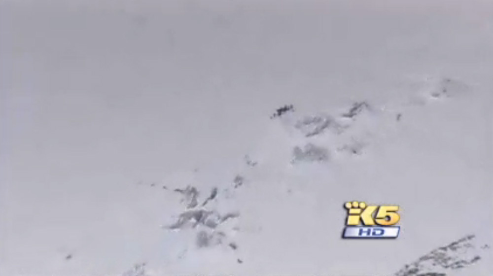
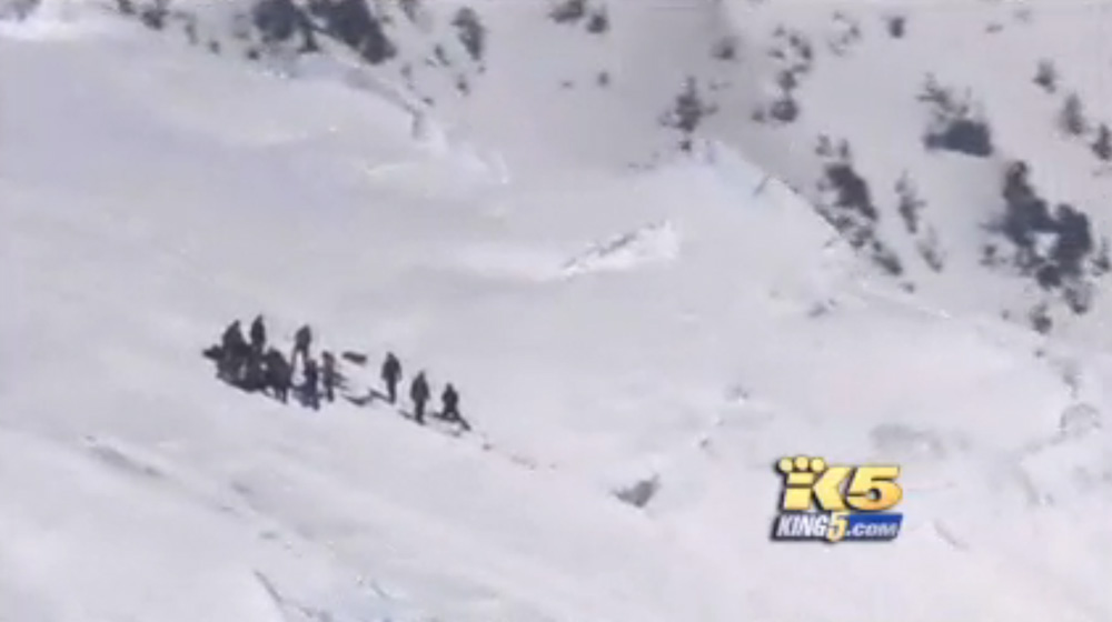
Here are a few screen captures from the KING-5 video (posted under the doctrine of fair use ) which clarify the exact location of the accident:
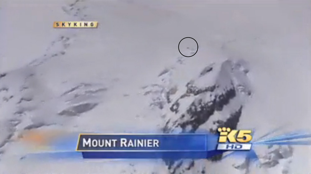
View looking east at the crevasse and rescue site:
Closeup of the crevasse and rescue site:
I don't think that the upper Nisqually Glacier per se has any great appeal to skiers, but it is the standard exit from / entrance to the Fuhrer Finger and Thumb routes. Both have grown increasingly popular as ski routes over the past several years, maybe much too popular in my opinion, given the serious hazards associated with the routes (mainly rockfall), far beyond the hazards of the Emmons. But both are great ski routes, direct and steep, so the appeal is obvious. The upper Nisqually is also the continuation above the Nisqually Icefall, but that route is rarely in condition for skiing in spring and so it is very rarely skied (e.g. it looked good a few weeks ago, but already has broken up considerably as of May 10).
The upper Nisqually is not particularly nasty in proper season most years, since the crevasses are generally well-filled on the smooth middle portion of the glacier from 14000 ft down to 12500 ft. The only serious crevasse issues on-route occur from about 12000-12500 ft. When those crevasses become impassible (or nearly so), the upper continuation of the Fuhrer routes goes up the very steep (50-55 degree) flank of Wapowety Cleaver above 12000 ft instead of onto the upper Nisqually.
I was skinning up the Muir Snowfield on May 10, and around 1pm the KING-5 helicopter began circling overhead and above the south side of the upper mountain. Feared the worst after the helicopter lingered and kept circling (not just a quick scenic flyby), which was confirmed when two climbing rangers passed me at 9800 ft at 1:45pm, skinning uphill at max speed. A brief chat as I struggled to keep pace with them confirmed that a body recovery mission was underway, with the park's helicopter being fueled at the Kautz helibase and then heading up to pick up the rangers at Muir.
It turns out that the party was skinning up, not skiing down. Much more new info in this article:
www.thenewstribune.com/2011/05/11/166178...n-mount-rainier.html
Rangers unsure how skier fell into crevasse on way up Rainier
CRAIG HILL; STAFF WRITER
Published: 05/12/11 3:44 am | Updated: 05/12/11 4:46 am
A day after Tucker Taffe fell into a crevasse high on Mount Rainier, climbing rangers still were trying to piece together precisely how the deadly accident unfolded.
Park climbing ranger Glenn Kessler, one of the directors of the recovery, said the 33-year-old Utah man was ascending the mountain on skis about 8:25 a.m. when a member of his party noticed he’d vanished.
“By his own admission, the person behind him didn’t quite understand what had happened,” Kessler said.
Not until they came across the crevasse and one of Taffe’s skis did they realize the gravity of the situation. Taffe fell an estimated 100-150 feet into the crevasse.
Initially, rangers and other rescuers assumed Taffe and his three partners had summited the 14,411 foot mountain and were making their descent on skis. However, the group was attempting to ascend on skis.
Does anybody know any more details about the descent being attempted? Looking at the king5 video, it looked like the rescue took place just above the Nisqually Ice Cliff. If that was the objective, wow. Can you extreme skiers out there comment on what descents are possible from there?
I could be wrong but from the King5 video it looks like the accident was skier's right of the Nisqually Cleaver. From that location it should be possible to reach the Fuhrer Finger, not sure what other (more extreme) fall-line options are in this year. I think Seth's recent descent of the icecliff would have been skier's _left_ of the cleaver, correct?
The accident site was just west of Nisqually Cleaver, see the images below. Hearsay at Camp Muir on May 10 was that the party had climbed Fuhrer Finger and that was presumably their intended ski descent too, but I have no idea if that info is correct.
However, it looks like a non-standard place for them to have been skinning up, right beside a bunch of exposed seracs and partially open crevasses. It's more dangerous in that area (as confirmed by the accident), while the safer standard route is down the obvious central fall line of the upper Nisqually Glacier, a few hundred feet farther west. That is the most snow-filled and least crevassed portion of the upper Nisqually, and the line that almost all parties ascend and ski as far as I know. The standard line is not very far west of where the accident occurred, but a hundred feet left or right can be an entirely different route in some places on a glacier, with an entirely different degree of crevasse hazard. But it's also appealing to ski and photograph near exposed seracs and open crevasses, so it's easy to understand why they might have taken the line they did.
Here are a few screen captures from the KING-5 video (posted under the doctrine of fair use ) which clarify the exact location of the accident:
View looking east at the crevasse and rescue site:
Closeup of the crevasse and rescue site:
Also, although I've skied many different parts of Rainier below ~10k, above that I've been on only the relatively tame Emmons, but my understanding is that the upper Nisqually can be pretty nasty? Is the deep snowpack making it more appealing to skiers now, but with monster crevasses lurking beneath snowbridges that are not as safe as they seem?
I don't think that the upper Nisqually Glacier per se has any great appeal to skiers, but it is the standard exit from / entrance to the Fuhrer Finger and Thumb routes. Both have grown increasingly popular as ski routes over the past several years, maybe much too popular in my opinion, given the serious hazards associated with the routes (mainly rockfall), far beyond the hazards of the Emmons. But both are great ski routes, direct and steep, so the appeal is obvious. The upper Nisqually is also the continuation above the Nisqually Icefall, but that route is rarely in condition for skiing in spring and so it is very rarely skied (e.g. it looked good a few weeks ago, but already has broken up considerably as of May 10).
The upper Nisqually is not particularly nasty in proper season most years, since the crevasses are generally well-filled on the smooth middle portion of the glacier from 14000 ft down to 12500 ft. The only serious crevasse issues on-route occur from about 12000-12500 ft. When those crevasses become impassible (or nearly so), the upper continuation of the Fuhrer routes goes up the very steep (50-55 degree) flank of Wapowety Cleaver above 12000 ft instead of onto the upper Nisqually.
Please Log in or Create an account to join the conversation.
- Lowell_Skoog
-

- User
-
Less
More
- Posts: 1460
- Thank you received: 16
15 years 1 week ago - 15 years 1 week ago #200113
by Lowell_Skoog
Thanks Amar. From the pictures, it looks like the accident occurred in a "lateral shear" zone of the glacier. (I'm making up the term--I don't know what a glaciologist would call it.) It's an area where the glacier is being ripped open due to the motion of the ice (looker's left) with respect to the cleaver (looker's right). That seems like an area where crevasses might be continually opening and re-bridging (thinly) during a snowy spring like we've been having.
Replied by Lowell_Skoog on topic Re: Mount Rainier Rescue..>5-10-11
However, it looks like a non-standard place for them to have been skinning up, right beside a bunch of exposed seracs and partially open crevasses. It's more dangerous in that area (as confirmed by the accident), while the safer standard route is down the obvious central fall line of the upper Nisqually Glacier, a few hundred feet farther west. That is the most snow-filled and least crevassed portion of the upper Nisqually, and the line that almost all parties ascend and ski as far as I know. The standard line is not very far west of where the accident occurred, but a hundred feet left or right can be an entirely different route in some places on a glacier, with an entirely different degree of crevasse hazard. But it's also appealing to ski and photograph near exposed seracs and open crevasses, so it's easy to understand why they might have taken the line they did.
Thanks Amar. From the pictures, it looks like the accident occurred in a "lateral shear" zone of the glacier. (I'm making up the term--I don't know what a glaciologist would call it.) It's an area where the glacier is being ripped open due to the motion of the ice (looker's left) with respect to the cleaver (looker's right). That seems like an area where crevasses might be continually opening and re-bridging (thinly) during a snowy spring like we've been having.
Please Log in or Create an account to join the conversation.
- Pete A
-
- User
-
Less
More
- Posts: 431
- Thank you received: 0
15 years 1 week ago #200114
by Pete A
Replied by Pete A on topic Re: Mount Rainier Rescue..>5-10-11
glad that a few more details are coming out... does seem like an atypical place to be on the upper mtn... i suppose if one was ascending via a standard camp muir route like the Ingraham or Gib Ledges and you wanted to get a look at the FF approach/upper Nisq. before skiing it, you'd traverse the upper mtn the get over there.
Please Log in or Create an account to join the conversation.
- skiWednesdays
-
- User
-
Less
More
- Posts: 2
- Thank you received: 0
15 years 6 days ago #200145
by skiWednesdays
How likely is one to die climbing Mt. Rainier? (I don't have any data for just crevasse fall) This of course depends on your route, skill and judgement. The more of the later might not offset choosing a harder route. (One time I looked at this deaths on the Liberty Ridge Route were about 10x the total rate.
Looking at some deaths vs attempts one gets a very crude rate of .018%.
For autos I found goggling the rate is 1.45 per 100 million miles.
I drive about 12,000 miles a year, so that would be .0174% for the whole year.
From Portland it is about 400 miles (might be 500 but I am too lazy to look it up, in any event it will vary for each of us) round-trip or a rate of .0006%
So obviously both rates are very small, the climbing rate is about 30 times higher (30 *.0006% = .018%), higher if you live closer. So it more like driving to the mountain 30 times, not so bad I guess. But if you do a whole allot of this for a very long time it adds (well multiplies up):
The chance you are still alive after one climb is 1-.018% = 99.982%.
Lets say you are guide climbing every week then the chance that you are alive at the end of year is 99.982%^52 or about 99%.
If you do this for 30 years you have about a 75% chance of not dying from climbing (I have ignored that you might have died in the mean time by some other cause.).
My chances of not dying from driving during a 30 year period is (1-.0174%) ^30 or about 99.5%
Hopefully I haven't made some math error.
Replied by skiWednesdays on topic Re: Mount Rainier Rescue..>5-10-11
I wonder how the "death/injury by crevasse fall" statistics stack up compared to "death/injury by auto accident driving to/from the mountains"
How likely is one to die climbing Mt. Rainier? (I don't have any data for just crevasse fall) This of course depends on your route, skill and judgement. The more of the later might not offset choosing a harder route. (One time I looked at this deaths on the Liberty Ridge Route were about 10x the total rate.
Looking at some deaths vs attempts one gets a very crude rate of .018%.
For autos I found goggling the rate is 1.45 per 100 million miles.
I drive about 12,000 miles a year, so that would be .0174% for the whole year.
From Portland it is about 400 miles (might be 500 but I am too lazy to look it up, in any event it will vary for each of us) round-trip or a rate of .0006%
So obviously both rates are very small, the climbing rate is about 30 times higher (30 *.0006% = .018%), higher if you live closer. So it more like driving to the mountain 30 times, not so bad I guess. But if you do a whole allot of this for a very long time it adds (well multiplies up):
The chance you are still alive after one climb is 1-.018% = 99.982%.
Lets say you are guide climbing every week then the chance that you are alive at the end of year is 99.982%^52 or about 99%.
If you do this for 30 years you have about a 75% chance of not dying from climbing (I have ignored that you might have died in the mean time by some other cause.).
My chances of not dying from driving during a 30 year period is (1-.0174%) ^30 or about 99.5%
Hopefully I haven't made some math error.
Please Log in or Create an account to join the conversation.
- caverpilot
-
- User
-
Less
More
- Posts: 3
- Thank you received: 0
15 years 6 days ago #200151
by caverpilot
Replied by caverpilot on topic Re: Mount Rainier Rescue..>5-10-11
Odds of dying, lifetime: 1 in 1
Heart Disease: 1 in 5
Cancer: 1 in 7
Stroke: 1 in 24
Car Accident 1 in 84-100
I've always told my worrysome friends that my odds of dying in the mountains would always be less than dying on the drive to the mountain. There's 40,000 auto-related deaths annually, and a few mountaineering fatalities. It all depends on how much you drive, versus how much you climb, and probably where you climb (crevasse/serac-laden peaks versus not). Great food for thought, though!
This is fairly interesting: Actuarial Life Tables
Of course, we have to adjust that table for technology- the longer we live, the greater our life expectancy. Weird. (When I was born the life expectancy for males was lower than it is now)
Please Log in or Create an account to join the conversation.