- Posts: 260
- Thank you received: 0
Forest Serv. replaces bridge w/ pile of snowballs
- Alan Brunelle
-

- User
-

Less
More
15 years 2 months ago #199760
by Alan Brunelle
I remember that log "bridge of death". My son and I crossed it that year and I had to back off in the morning for fear. He seemed to have no problem, but I had too much coffee on the drive up and could not keep steady. I did not like it and we could not be so lucky that such a tree could fall to even get a new bridge of death formed.
I had thought of an aluminum bridge such as the army might use that could be dropped in place in the spring, yet removed when the snows come.
Also, maybe an alternate solution is to suspend a walkway in such a way that it any snow slides would flow underneath. I am not sure how high the snow is at that point now, but using this slide and the other as possible historic events, they could design one that is a foot or more higher. Given a proper design, even if the snow were to clip such a structure, it might deflect and be retrievable rather than destroyed.
Alan
Replied by Alan Brunelle on topic Re: Forest Serv. replaces bridge w/ pile of snowballs
The crossing over Grouse Creek at this point would be very dangerous without a bridge. There was actually an accident a few years back that happened in a guided party where a client fell off the "bridge of death", was injured and had to be rescued.
I remember that log "bridge of death". My son and I crossed it that year and I had to back off in the morning for fear. He seemed to have no problem, but I had too much coffee on the drive up and could not keep steady. I did not like it and we could not be so lucky that such a tree could fall to even get a new bridge of death formed.
I had thought of an aluminum bridge such as the army might use that could be dropped in place in the spring, yet removed when the snows come.
Also, maybe an alternate solution is to suspend a walkway in such a way that it any snow slides would flow underneath. I am not sure how high the snow is at that point now, but using this slide and the other as possible historic events, they could design one that is a foot or more higher. Given a proper design, even if the snow were to clip such a structure, it might deflect and be retrievable rather than destroyed.
Alan
Please Log in or Create an account to join the conversation.
- kurthicks
-
- User
-
Less
More
- Posts: 10
- Thank you received: 0
15 years 2 months ago #199761
by kurthicks
Replied by kurthicks on topic Re: Forest Serv. replaces bridge w/ pile of snowballs
When they were replacing the bridge a few years ago (with the first one in the photos above) after the old one broke, we were all accessing the north side by walking downstream from the bridge location for about 100' to where the little canyon ends, hopping easily across rocks and small logs, then trudging up the hill on the other side...not sketchy at all from what I remember and a fine alternative to rebuilding that bridge yet again.
Please Log in or Create an account to join the conversation.
- Pinch
-
- User
-
Less
More
- Posts: 289
- Thank you received: 0
14 years 8 months ago #201989
by Pinch
Replied by Pinch on topic Re: Forest Serv. replaces bridge w/ pile of snowballs
I don't really know what to make of this photo. I can't say that I have seen anything like it before. This photo was taken September 28th, 2011. 5+ months after the big Grouse Cr. avalanche, in which this was the start zone. Could it be possible that this is a remnant of the start of that slide, including crown line and stauchwall?? It's remarkable that any crown (on such a slope) is still evident this late in the season, whenever it happened. Was it hidden under subsequent snowfall, only to reemerge half a year later!!? After looking with binoculars, I discounted the thought that it was a glide crack crevasse, which sometimes occur on the ridge lookers left.
Please Log in or Create an account to join the conversation.
- Gregg_C
-
- User
-
Less
More
- Posts: 149
- Thank you received: 0
14 years 8 months ago - 14 years 8 months ago #201993
by Gregg_C
Replied by Gregg_C on topic Re: Forest Serv. replaces bridge w/ pile of snowballs
Toby,
I saw that when I was skinning up in the half light just prior to dawn in late March when Louie and I did the Watson. Scared the piss out of me as I didn't know if it was recent. (Day before?, that night?--Definately got my attention). As the light increased I saw the crown line (six feet) and the debris a quarter mile down slope. Big chunks of debris where under 2-3 feet of snow. I don't think this was part of the big slide that took out the bridge, which would explain its continued appearance in the snow pack.
I saw that when I was skinning up in the half light just prior to dawn in late March when Louie and I did the Watson. Scared the piss out of me as I didn't know if it was recent. (Day before?, that night?--Definately got my attention). As the light increased I saw the crown line (six feet) and the debris a quarter mile down slope. Big chunks of debris where under 2-3 feet of snow. I don't think this was part of the big slide that took out the bridge, which would explain its continued appearance in the snow pack.
Please Log in or Create an account to join the conversation.
- Amar Andalkar
-
- User
-
Less
More
- Posts: 635
- Thank you received: 0
12 years 10 months ago #210222
by Amar Andalkar
Most of us are very good at criticizing the USFS (or NPS, or most other government agencies) whenever anything goes wrong or contrary to our wishes on any of the areas that they administer. However, somehow we find it much harder to give plaudits to those same agencies when such praise is appropriate and due. As it is in this case.
I didn't realize it until I saw a random picture today, but the USFS used money from recreation fees (the much-reviled Northwest Forest Pass) to salvage, reinstall, and repair this Grouse Creek bridge during August 2012.
This is how things looked as of July 2012, with the bridge still destroyed since the April 2011 avalanche (quoted from Lowell's report: July 6-7, 2012, Mount Baker, Coleman Route , since I did not ski the C-D route or take photos of the bridge site during 2012):
And this is the random photo from May 2013 which made me realize today that the bridge had been unexpectedly repaired:
(from foursquaremountaineering.blogspot.com/20.../mt-baker-51113.html )
I had not previously heard that this bridge had been repaired, but some searching on WTA turned up this report ( www.wta.org/go-hiking/trip-reports/trip_...012-09-02.8563713255 ) which indicates the bridge was repaired at the end of August 2012. And a bit of Google searching turned up this PDF file, Mt. Baker-Snoqualmie National Forest: Fee Accomplishment Report 2012 , which states, "Demolished by an avalanche, this bridge over Heliotrope Creek was salvaged and repaired with recreation fees." Image cropped from the PDF file:
See www.fs.usda.gov/detail/mbs/passes-permit.../?cid=fsbdev2_026999 for links to similar PDFs for each year since 2003 for most National Forests in the Pacific Northwest.
It's great to actually see for real that this money (at least some portion of it) is being spent for tangible improvements and benefits to important recreation access routes.
Replied by Amar Andalkar on topic Re: Forest Serv. replaces bridge w/ pile of snowballs
So the nice new steel and timber bridge built in June-July 2010 is gone, eh?
Some Google searching turned up the construction contract and drawings:
Grouse Creek Trail Bridge, Mt Baker Ranger District
www.fbo.gov/index?s=opportunity&mode=for...89&tab=core&_cview=1
$30,400!
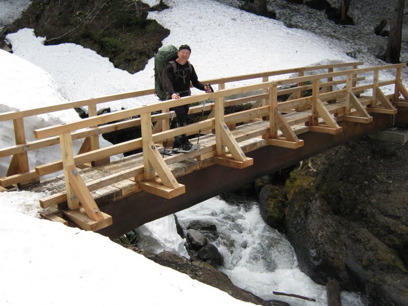
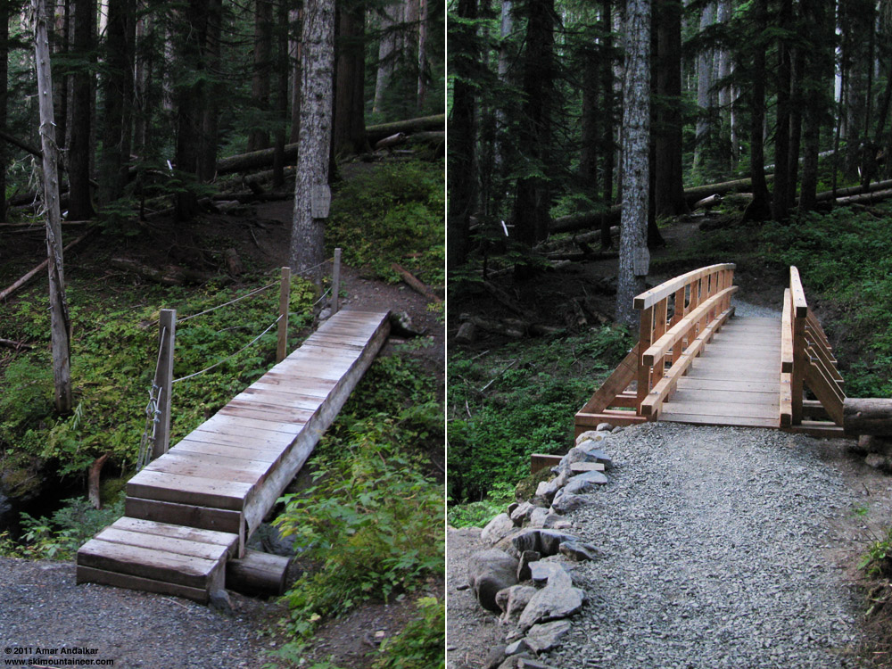
Here's the old bridge on the Heliotrope Ridge trail in October 2009, and the new bridge just after completion in July 2010:
Most of us are very good at criticizing the USFS (or NPS, or most other government agencies) whenever anything goes wrong or contrary to our wishes on any of the areas that they administer. However, somehow we find it much harder to give plaudits to those same agencies when such praise is appropriate and due. As it is in this case.
I didn't realize it until I saw a random picture today, but the USFS used money from recreation fees (the much-reviled Northwest Forest Pass) to salvage, reinstall, and repair this Grouse Creek bridge during August 2012.
This is how things looked as of July 2012, with the bridge still destroyed since the April 2011 avalanche (quoted from Lowell's report: July 6-7, 2012, Mount Baker, Coleman Route , since I did not ski the C-D route or take photos of the bridge site during 2012):
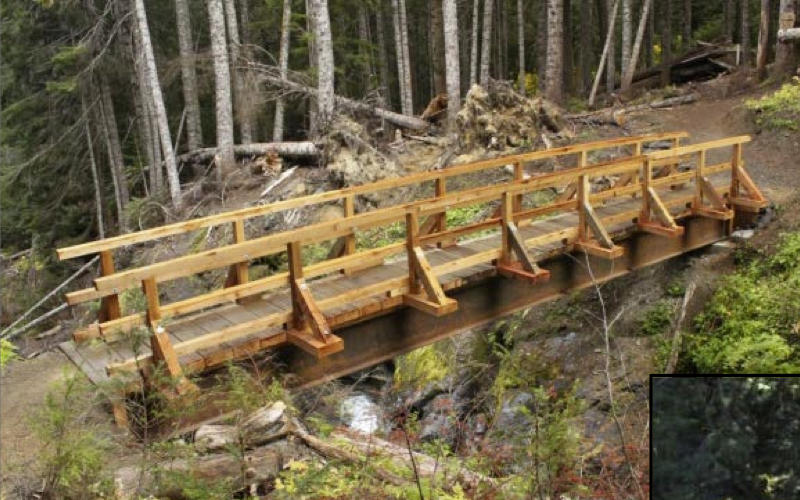
Tom at the site of the Grouse Creek bridge:

The bridge was tossed 100 feet into the forest. (The perspective in this picture makes the bridge look smaller than it is.)

And this is the random photo from May 2013 which made me realize today that the bridge had been unexpectedly repaired:
(from foursquaremountaineering.blogspot.com/20.../mt-baker-51113.html )
I had not previously heard that this bridge had been repaired, but some searching on WTA turned up this report ( www.wta.org/go-hiking/trip-reports/trip_...012-09-02.8563713255 ) which indicates the bridge was repaired at the end of August 2012. And a bit of Google searching turned up this PDF file, Mt. Baker-Snoqualmie National Forest: Fee Accomplishment Report 2012 , which states, "Demolished by an avalanche, this bridge over Heliotrope Creek was salvaged and repaired with recreation fees." Image cropped from the PDF file:
See www.fs.usda.gov/detail/mbs/passes-permit.../?cid=fsbdev2_026999 for links to similar PDFs for each year since 2003 for most National Forests in the Pacific Northwest.
It's great to actually see for real that this money (at least some portion of it) is being spent for tangible improvements and benefits to important recreation access routes.
Please Log in or Create an account to join the conversation.
- Pinch
-
- User
-
Less
More
- Posts: 289
- Thank you received: 0
12 years 10 months ago #210228
by Pinch
Replied by Pinch on topic Re: Forest Serv. replaces bridge w/ pile of snowballs
....just an addition. Glacier Creek Road is CLOSED. No schedule for repair.
Please Log in or Create an account to join the conversation.