- Posts: 259
- Thank you received: 0
Mount Rainier Paradise reaches 200" snow depth
- philfort
-

- User
-

Less
More
15 years 3 months ago #198807
by philfort
The sno-tel site on the SW side of the Olympics shows a 196" snow depth right now, roughly what Paradise has:
www.wcc.nrcs.usda.gov/nwcc/sntl-data0000...1107&days=7&state=wa
Replied by philfort on topic Re: Mount Rainier Paradise reaches 200" snow depth
When I spoke to you about this before Amar, you mentioned that the area around the Blue Glacier on Mount Olympus contends with other regions of the World that get potentially more snow than paradise. How would you guess this compares to places in SE Alaska?
The sno-tel site on the SW side of the Olympics shows a 196" snow depth right now, roughly what Paradise has:
www.wcc.nrcs.usda.gov/nwcc/sntl-data0000...1107&days=7&state=wa
Please Log in or Create an account to join the conversation.
- garyabrill
-
- User
-
Less
More
- Posts: 464
- Thank you received: 0
15 years 3 months ago #198811
by garyabrill
Replied by garyabrill on topic Re: Mount Rainier Paradise reaches 200" snow depth
I got my information regarding Mt. Baker by a phone call in 1990 to NWAC and have had it since. It is possible it remains in their archives.
Please Log in or Create an account to join the conversation.
- Amar Andalkar
-
Topic Author
- User
-
Less
More
- Posts: 635
- Thank you received: 0
15 years 3 months ago #198857
by Amar Andalkar
Actually, if you look at the hourly data ( www.wcc.nrcs.usda.gov/nwcc/sntl-datarpt....1107&days=7&state=wa ), you can see that the 196" value is an error -- the snowdepth jumps from 180" to 196" at 1400 on March 10, and then stays there afterwards. So it looks like 196" is the height that the ultrasonic snowdepth sensor is mounted above the ground, and it gives that value if the sensor is obstructed. However, given the continued snowfall the last few days, the real snowdepth has probably exceeded 196" by now at that site, and the sensor is probably buried and will provide no useful data for the rest of the season until the snowpack melts down in early summer.
It's a shame that when the NRCS finally added snowdepth sensors to all of their SNOTEL sites a couple of years ago (previously most SNOTEL sites had only temperature, precip, and snow-water equivalent), they mounted many of the snowdepth sensors far too low, at roughly 200" or 240" above the ground where they would easily get buried by the snowpack in any fat snowpack year. I can't believe that they didn't realize that the sensors needed to be mounted at least 300" high (or even 360" for some sites) in order to be safely above the level of an above-average snowpack. The one at Swift Creek SNOTEL at 4400 ft on the south side of Mt St Helens gets buried like that in each good snow year, which is really disappointing since this is an exceptionally high-snowfall site which often approaches or exceeds Paradise or Baker Ski Area in its snowdepth, and also located right near a major ski mountaineering route (Worm Flows). They need to raise the height of the snowdepth sensors at these high-snowfall sites to avoid this foolish loss of good snowdepth data, especially in the huge years when it is most useful and interesting.
It would be interesting to find the daily records from that period -- 480+" would be amazing! There is NWAC telemetry data for Mount Baker Ski Area from the 1989-90 season, which I looked through today, but it has no 24 hour snowdepth or total snowdepth data. Anyway, it looks like the period of interest runs from January 22 to February 17, 1990 (a period of 27 days), based on the daily data from Paradise for those months from the official archives at the National Climatic Data Center:
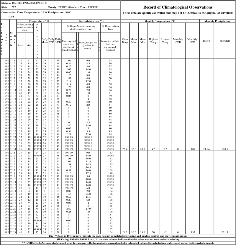
The total snowfall during the five days of missing data (January 27-31) was about 72", which I calculated based on NPS annual snowfall totals and which makes sense given that the snowdepth increases by 44" during that time. So Paradise received 52" (Jan 22-26) + about 72" (Jan 27-31) + 214" (Feb 1-17) = about 338" during the 27 day period. Based on that already-huge number at a site which is typically comparable in snowfall, it would be highly unlikely that Mount Baker Ski Area got 480+" during the same period -- but it certainly could have done so.
However, since the snowfall is split among two calendar months, the Baker snowfall would not be enough to exceed the calendar month record of 390" (since only about 300" of the 480" would probably be in February). When Mount Baker Ski Area got 303" in February of 1999 (during the record 1140" season), it was widely reported to be a new single-month record for that site, so Feb 1990 probably got less than that unless the 1999 news reports were erroneous.
Replied by Amar Andalkar on topic Re: Mount Rainier Paradise reaches 200" snow depth
The sno-tel site on the SW side of the Olympics shows a 196" snow depth right now, roughly what Paradise has:
www.wcc.nrcs.usda.gov/nwcc/sntl-data0000...1107&days=7&state=wa
Actually, if you look at the hourly data ( www.wcc.nrcs.usda.gov/nwcc/sntl-datarpt....1107&days=7&state=wa ), you can see that the 196" value is an error -- the snowdepth jumps from 180" to 196" at 1400 on March 10, and then stays there afterwards. So it looks like 196" is the height that the ultrasonic snowdepth sensor is mounted above the ground, and it gives that value if the sensor is obstructed. However, given the continued snowfall the last few days, the real snowdepth has probably exceeded 196" by now at that site, and the sensor is probably buried and will provide no useful data for the rest of the season until the snowpack melts down in early summer.
It's a shame that when the NRCS finally added snowdepth sensors to all of their SNOTEL sites a couple of years ago (previously most SNOTEL sites had only temperature, precip, and snow-water equivalent), they mounted many of the snowdepth sensors far too low, at roughly 200" or 240" above the ground where they would easily get buried by the snowpack in any fat snowpack year. I can't believe that they didn't realize that the sensors needed to be mounted at least 300" high (or even 360" for some sites) in order to be safely above the level of an above-average snowpack. The one at Swift Creek SNOTEL at 4400 ft on the south side of Mt St Helens gets buried like that in each good snow year, which is really disappointing since this is an exceptionally high-snowfall site which often approaches or exceeds Paradise or Baker Ski Area in its snowdepth, and also located right near a major ski mountaineering route (Worm Flows). They need to raise the height of the snowdepth sensors at these high-snowfall sites to avoid this foolish loss of good snowdepth data, especially in the huge years when it is most useful and interesting.
Whoa, now. How about January 1990 at Mt. Baker...actually a 3-1/2 week period ending around February 5 (approximate). Baker received just under 500" in that 3-1/2 week period (I don't recall exactly but something like mid 480's as reported by the ski area). Stevens got 330" in the same period. When the freezing level rose to 4500' briefly towards the end of that period the biggest slides in the Cascades since perhaps 1972 came down - notably the Phantom slide path on Snoqualmie, the slide path that crossed 20 beneath Ruby Mtn, and to my knowledge the biggest slide I know of in the Cascades in Grouse Creek - I'd guess that one took out 100 acres of old growth and reached an astonishing 400' up the opposite side of a narrow gully leaving an impressive trimline. The largest fracture I saw from Mt. Herman around February 5th was on the Mazama Glacier of Baker and having skied the Mazama once (for scale) I estimated the crown at 20-25 feet - probably about the same size as the Grouse Creek crown. There was a crown measured at 13' near the Blueberry ropetow. Other than those 3-1/2 weeks 1990 was a poor snow year.
Amar, the 1990 period of snowfall at Baker would break the record for a one month and 30 day period if it could be confirmed, i.e. if the records still exist. Since there was no telemetry at the time NWAC would have used the ski resorts daily weather station information.
It would be interesting to find the daily records from that period -- 480+" would be amazing! There is NWAC telemetry data for Mount Baker Ski Area from the 1989-90 season, which I looked through today, but it has no 24 hour snowdepth or total snowdepth data. Anyway, it looks like the period of interest runs from January 22 to February 17, 1990 (a period of 27 days), based on the daily data from Paradise for those months from the official archives at the National Climatic Data Center:
The total snowfall during the five days of missing data (January 27-31) was about 72", which I calculated based on NPS annual snowfall totals and which makes sense given that the snowdepth increases by 44" during that time. So Paradise received 52" (Jan 22-26) + about 72" (Jan 27-31) + 214" (Feb 1-17) = about 338" during the 27 day period. Based on that already-huge number at a site which is typically comparable in snowfall, it would be highly unlikely that Mount Baker Ski Area got 480+" during the same period -- but it certainly could have done so.
However, since the snowfall is split among two calendar months, the Baker snowfall would not be enough to exceed the calendar month record of 390" (since only about 300" of the 480" would probably be in February). When Mount Baker Ski Area got 303" in February of 1999 (during the record 1140" season), it was widely reported to be a new single-month record for that site, so Feb 1990 probably got less than that unless the 1999 news reports were erroneous.
Please Log in or Create an account to join the conversation.
- Amar Andalkar
-
Topic Author
- User
-
Less
More
- Posts: 635
- Thank you received: 0
15 years 3 months ago #198858
by Amar Andalkar
Olympus definitely gets more snowfall than anyplace in the Cascades, since the average annual precip on Blue Glacier is over 200" (something like 240" at the 7000 ft level if I remember correctly -- don't recall where I read that though). The annual precip at SNOTEL sites on the south sides of Mt St Helens and Mt Baker is about 170", and those are by far the wettest measurement sites in the Cascades. There have been snowdepth measurements taken on Blue Glacier and Snowdome by UW scientists since about 1958, but that data appears not to be available online, and in any case, snowdepth on glaciers is subject to significant enhancement from wind-loading, compared to a neutral site like a subalpine clearing in open forest. So I don't know if there is a way to make a direct comparison.
Based on annual precip, it seems certain that areas in SE Alaska have greater snowfall than the Olympics -- there are areas of SE Alaska which get over 200" of annual precip at sea level (Little Port Walter averages 228"), with amounts likely exceeding 300" at a few thousand feet elevation in favored locations. Given the more northerly latitude and the greater precip, snowfall and snowdepths must be much greater there than in the Olympics.
I have no idea if areas in the central part of the BC Coast Mountains (i.e. the Waddington / Silverthrone area) receive comparable precip and snowfall to the most favored areas of SE Alaska or not. But Henderson Lake near sea level on Vancouver Island is the rainiest measurement site in North America, with average annual precip of 256", and so the highest peaks on the island in Strathcona Park presumably receive huge snowfalls. No measurement sites are located in the highest snowfall areas though.
But the central BC Coast Mountains are somewhat in the rainshadow of Vancouver Island, and I have not seen any good data for either precip or snowpack in that area, and do not think that any exists. The three BC snow telemetry sites in the area ( bcrfc.env.gov.bc.ca/data/asp/realtime/ , sites 3C08P, 3A22P, 3A24P) are located in really low snowfall spots, I mean these places get an average snow-water equivalent of 12-30", corresponding to meager snow depths of 30-75". Obviously, seasonal snow depths in more favored locations near Waddington or Silverthrone must be several times greater than that, to support the large glaciers descending to nearly sea level.
Replied by Amar Andalkar on topic Re: Mount Rainier Paradise reaches 200" snow depth
When I spoke to you about this before Amar, you mentioned that the area around the Blue Glacier on Mount Olympus contends with other regions of the World that get potentially more snow than paradise. How would you guess this compares to places in SE Alaska?
Olympus definitely gets more snowfall than anyplace in the Cascades, since the average annual precip on Blue Glacier is over 200" (something like 240" at the 7000 ft level if I remember correctly -- don't recall where I read that though). The annual precip at SNOTEL sites on the south sides of Mt St Helens and Mt Baker is about 170", and those are by far the wettest measurement sites in the Cascades. There have been snowdepth measurements taken on Blue Glacier and Snowdome by UW scientists since about 1958, but that data appears not to be available online, and in any case, snowdepth on glaciers is subject to significant enhancement from wind-loading, compared to a neutral site like a subalpine clearing in open forest. So I don't know if there is a way to make a direct comparison.
Based on annual precip, it seems certain that areas in SE Alaska have greater snowfall than the Olympics -- there are areas of SE Alaska which get over 200" of annual precip at sea level (Little Port Walter averages 228"), with amounts likely exceeding 300" at a few thousand feet elevation in favored locations. Given the more northerly latitude and the greater precip, snowfall and snowdepths must be much greater there than in the Olympics.
As far as where the greatest snows are my vote would be for Mt. Silverthrone in the BC coast mountains where the Klinaklini Glacier descends 20+ miles, still extending to just 500-800' above sea level. I flew over the snout of the Klinaklini on a sight seeing daytrip two years ago. Five miles above the snout the glacier (maybe at 5000') still rises nearly to it's trimlines. There are several mile wide feeder glaciers. Apparently in the last ice age the apex of glaciation was at the latitude of Tweedsmuir Park with glaciers flowing both ways from that point (I don't remember where I got that trivia) so it would make sense that would be the zone of heaviest snowfall.
I have no idea if areas in the central part of the BC Coast Mountains (i.e. the Waddington / Silverthrone area) receive comparable precip and snowfall to the most favored areas of SE Alaska or not. But Henderson Lake near sea level on Vancouver Island is the rainiest measurement site in North America, with average annual precip of 256", and so the highest peaks on the island in Strathcona Park presumably receive huge snowfalls. No measurement sites are located in the highest snowfall areas though.
But the central BC Coast Mountains are somewhat in the rainshadow of Vancouver Island, and I have not seen any good data for either precip or snowpack in that area, and do not think that any exists. The three BC snow telemetry sites in the area ( bcrfc.env.gov.bc.ca/data/asp/realtime/ , sites 3C08P, 3A22P, 3A24P) are located in really low snowfall spots, I mean these places get an average snow-water equivalent of 12-30", corresponding to meager snow depths of 30-75". Obviously, seasonal snow depths in more favored locations near Waddington or Silverthrone must be several times greater than that, to support the large glaciers descending to nearly sea level.
Please Log in or Create an account to join the conversation.
- Amar Andalkar
-
Topic Author
- User
-
Less
More
- Posts: 635
- Thank you received: 0
15 years 3 months ago #198867
by Amar Andalkar
Replied by Amar Andalkar on topic Re: Mount Rainier Paradise reaches 200" snow depth
Well, even though Paradise won the race to reach 200" by a few hours, Baker Ski Area has totally charged ahead since then, and now leads by about 30". Total snowfall over the last 100 hours has been about 26" at Paradise with a net loss of 3" of snowdepth due to settlement, while Baker has received about 60" of new snow during that time with a net gain of 32" of snowdepth.
A twice-daily summary of the data:
[tt]
Northwest Weather and Avalanche Center
Paradise, Mt Rainier National Park, Washington
MM/DD Hour Temp RH Wind Wind Wind Hour Total 24 Hr Total Solar
PST F % Avg Max Dir Prec. Prec. Snow Snow W/m2
5550' 5550' 5500' 5500' 5500' 5550' 5550' 5550' 5550' 5500'
3 10 500 31 100 16 24 271 .09 .09 14 201 0
3 10 600 28 100 18 28 271 .1 .19 17 202 0
3 10 1700 26 100 24 38 263 .05 .51 3 197 39
3 10 1800 26 100 24 35 264 .07 .58 3 197 19
3 11 500 20 97 10 16 258 0 0 6 197 0
3 11 600 21 96 10 17 259 0 0 6 196 0
3 11 1700 32 100 1 7 142 0 .03 6 193 114
3 11 1800 29 100 1 3 69 0 .03 6 193 25
3 12 500 28 96 3 8 145 0 0 5 192 0
3 12 600 29 95 4 11 1 0 0 5 191 0
3 12 1700 29 99 12 16 260 .01 .37 2 197 142
3 12 1800 28 100 10 13 266 0 .37 2 197 71
3 13 500 33 99 6 11 306 0 0 2 195 0
3 13 600 33 99 5 18 327 .01 .01 2 195 0
3 13 1700 32 100 13 26 271 .2 .47 2 196 11
3 13 1800 30 100 13 26 281 .04 .51 3 196 7
3 14 500 27 100 22 30 272 .02 .67 6 198 0
3 14 600 27 100 20 29 274 .01 .68 6 198 0
Northwest Weather and Avalanche Center
Mt Baker Ski Area, Washington
Wind sensors unheated and may rime
Precip gage appears to be under-recording 2-27-2011
MM/DD Hour Temp Temp RH RH Wind Wind Wind Wind Hour Total 24 Hr Total
PST F F % % Min Avg Max Dir Prec. Prec. Snow Snow
5000' 4210' 5000' 4210' 5000' 5000' 5000' 5000' 4210' 4210' 4210' 4210'
3 10 500 29 32 100 100 11 35 58 195 0.06 0.06 9 196
3 10 600 28 31 100 100 12 26 49 218 0.07 0.13 10 197
3 10 1700 28 31 100 100 6 15 25 164 0.13 0.81 8 203
3 10 1800 27 30 100 100 10 20 30 181 0.10 0.91 9 204
3 11 500 22 25 100 99 8 14 20 183 0.00 0.00 15 207
3 11 600 22 25 100 99 8 14 23 161 0.00 0.00 15 206
3 11 1700 25 28 100 99 6 14 25 148 0.02 0.27 21 211
3 11 1800 25 28 100 99 6 11 20 189 0.03 0.30 23 212
3 12 500 26 29 100 100 1 8 17 127 0.07 0.07 29 217
3 12 600 26 30 100 100 6 12 19 127 0.07 0.14 30 219
3 12 1700 27 30 100 99 9 21 32 170 0.00 0.85 11 223
3 12 1800 27 30 100 100 10 21 30 178 0.00 0.85 11 222
3 13 500 27 31 100 99 1 11 25 216 0.00 0.00 11 219
3 13 600 28 31 100 100 5 13 24 224 0.08 0.08 12 219
3 13 1700 32 33 100 99 0 0 0 192 0.09 1.29 7 224
3 13 1800 30 33 100 100 0 0 0 192 0.08 1.37 8 225
3 14 500 26 29 100 100 0 0 0 192 0.03 1.77 14 227
3 14 600 26 30 100 99 0 0 0 192 0.02 1.79 0 228
[/tt]
Please Log in or Create an account to join the conversation.
- garyabrill
-
- User
-
Less
More
- Posts: 464
- Thank you received: 0
15 years 3 months ago - 15 years 3 months ago #198870
by garyabrill
Replied by garyabrill on topic Re: Mount Rainier Paradise reaches 200" snow depth
Amar, I'll look at my photos to see what date it was when I was on Mt. Herman. I recall that it was clear and just a couple of days after the avalanche cycle. I also recall thinking that the crown on the Mazama Glacier made sense given some 500" of snowfall.
I checked my photos and indeed 1989-1990 was indeed highly unusual. I skied at Rainy Pass on December 21st of that year (auto access), then made a long solo ski tour on January 18th of 1990 in the North Cascades (in very stable conditions).
The photos on Mt. Herman are labeled about February 15, 1990. It was also clear the next day when I toured near Stevens on about February 16, 1990. I'd guess those dates could be off by 1 or 2 days. So, the incredible snowfall of 1990 is bracketed by those dates, January 19 and about February 15th - the 17th could be correct from your Paradise examination. On March 1, 1990 I skied the huge avalanche path off Windy ridge. I recall there was a 14" crust (the thickest I've ever seen) and we were skiing corn. So, the intense snowfall was very anomalous that winter.
Please Log in or Create an account to join the conversation.