- Posts: 635
- Thank you received: 0
January 16, 2011, MRNP, watching the snow go by
- Amar Andalkar
-

- User
-

Less
More
15 years 5 months ago #196688
by Amar Andalkar
Replied by Amar Andalkar on topic Re: January 16, 2011, MRNP, watching the snow go by
Looks like the afternoon predictions of 10,000+ cfs were way overblown, and they quickly revised the predictions downward this evening:
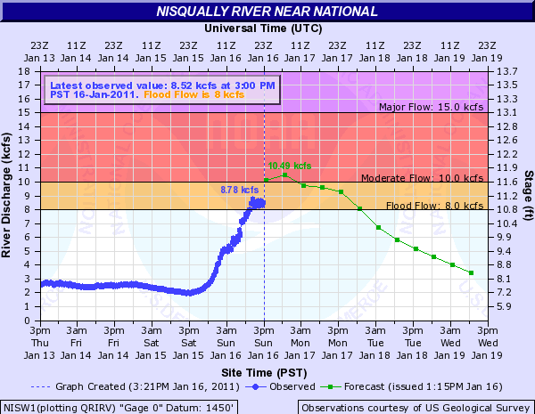
So the threat of destructive flooding appears to be minimal now from this event.
Gary, your link above is not working, it's missing a "?":
water.weather.gov/ahps2/hydrograph.php?w...w=1,1,1,1,1,1,1,1%22
And the full list of Historical Crests for Nisqually River near National is linked from that page (unfortunately in feet only, no kcfs listed):
water.weather.gov/ahps2/crests.php?wfo=sew&gage=nisw1
So today's maximum of about 11.2 ft will be around the 13th or 14th highest on record (going back to at least 1942) -- a fairly impressive flow, but nothing compared to the top 3 which have all occurred within the last 5 winters. The difference between 11 ft and 13 ft is huge, a doubling of the actual flow (and really more than double if levees are overtopped).
Please Log in or Create an account to join the conversation.
- Snowolf
-
- User
-
Less
More
- Posts: 34
- Thank you received: 0
15 years 4 months ago #196692
by Snowolf
Replied by Snowolf on topic Re: January 16, 2011, MRNP, watching the snow go b
Holy crap! This is so depressing.... Timberline Lodge picked up 8 1/2 inches of rain on Saturday. Mt Hood Meadows got 6 and they were reporting rates of 1/2 to 3/4 inch per hour. All operations at both resorts have shut down pending improvement to the weather.
My BC trip next week was looking iffy so instead of the Colorado guys coming here, I just bought a ticket to DIA on Southwest. Going to get some Colorado back country in!
My BC trip next week was looking iffy so instead of the Colorado guys coming here, I just bought a ticket to DIA on Southwest. Going to get some Colorado back country in!
Please Log in or Create an account to join the conversation.
- davidG
-
- User
-
Less
More
- Posts: 764
- Thank you received: 0
15 years 4 months ago #196693
by davidG
Replied by davidG on topic Re: January 16, 2011, MRNP, watching the snow go by
I was excited enough when USGS developed
WaterWatch
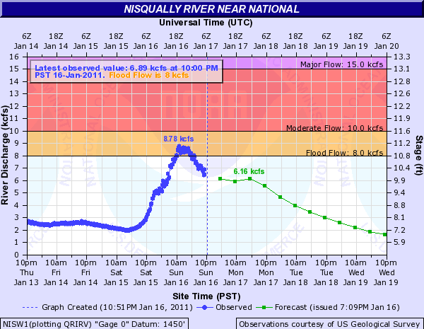
(switch to classic view - it loads faster), and the site became even more useful a couple of years ago when they started layering NWS forecasts over their observations. The forecast section of the streamflow is,of course, an algorithm largely influenced by the weather forecast, as well as, current flow trend and nature of the watershed. When the weather forecast turns out to be 'correct', I've found streamflow to reliably track the model, so Sunday's weather was drier than expected, here, and the evening forecast (Amars second snapshot) emphasized that reality.
If you approach archived data from the USGS side, you can find peak streamflows in cfs . Note the increased volatility of peak flows over time - a man-made condition or the intrinsic swing of nature? Interestingly, this USGS table of peak events does not include the 2009 12.68 ft event referenced in the crest list that Amar found.
And for those so inclined, USGS has added a new feature a few months ago, the Water Alert , which facilitates an automated mail (or text) message when a stream parameter (flow or height) reaches a user definable threshold. Totally cool - now i get alerted when my favorite streams are fishable - no matter where they are..
Please Log in or Create an account to join the conversation.
- davidG
-
- User
-
Less
More
- Posts: 764
- Thank you received: 0
15 years 4 months ago #196695
by davidG
hhmm. did that 5 inches run off or get sucked up? blower no more..
Replied by davidG on topic Re: January 16, 2011, MRNP, watching the snow go by
...
We met MRNP geomorphologists today who claimed the flow of the Nisqually leaving the park was less than 50% of the flow at the National gauge :, what do you think, Gary: is the flow of Big Creek/Cat Creek + Tenas and Goat Creeks greater than the combined flow of the Paradise River, Nisqually, Tahoma Creek, etc. etc., especially given that orographic precipitation meant Ashford got less than 2 inches pptn and Paradise got close to 5 inches!
hhmm. did that 5 inches run off or get sucked up? blower no more..
Please Log in or Create an account to join the conversation.
- Andrew Carey
-
 Topic Author
- User
-
Less
More
- Posts: 914
- Thank you received: 0
15 years 4 months ago - 15 years 4 months ago #196696
by Andrew Carey
Replied by Andrew Carey on topic Re: January 16, 2011, MRNP, watching the snow go by
Talking to people who where up at and above Paradise, it seems the snow level was lower than predicted by the models (Saturday it was snowing at 6,000 feet asl according to 1 witness, whereas predicted was 8,000-9,000 ft asl). This, and the saturated soil down below feeding the lower upper ") Nisqually (as Gary suggested) may very well have affected the proportion of the flow coming out of the park vs flowing into the river between the park and the gage at National. In other words, lower snow levels might well have removed 2,000 cfs or more from the park flow given the rainfall at Paradise was remarkably close to the amount predicted by the most generous model. The recorded flows of 8,500 cfs only briefly visually appeared as strong as some 8,000-9,000 cfs in the past did just inside and outside of the park boundary, but the river has incised significantly since 2006 and lots of woody debris has been washed downstream. Nevertheless, even though the crest appeared lower than in the past, the velocity of the river was as fast as I've every seen it with large old-growth cottonwood tree boles moving faster than I (or even my quicker spouse) could run; in our recollections of years of whitewater rafting, we could only recall on incident when the water was a flowing as fast as yesterday.
Nisqually (as Gary suggested) may very well have affected the proportion of the flow coming out of the park vs flowing into the river between the park and the gage at National. In other words, lower snow levels might well have removed 2,000 cfs or more from the park flow given the rainfall at Paradise was remarkably close to the amount predicted by the most generous model. The recorded flows of 8,500 cfs only briefly visually appeared as strong as some 8,000-9,000 cfs in the past did just inside and outside of the park boundary, but the river has incised significantly since 2006 and lots of woody debris has been washed downstream. Nevertheless, even though the crest appeared lower than in the past, the velocity of the river was as fast as I've every seen it with large old-growth cottonwood tree boles moving faster than I (or even my quicker spouse) could run; in our recollections of years of whitewater rafting, we could only recall on incident when the water was a flowing as fast as yesterday.
G: the USGS in numerical format: Nisqually numbers that include a water year 2009 12.82 ft but it occurred in Nov 2008 (I left NP before it got that high because at 10,000-11,000 cfs standing waver heights were above the levee.
Nisqually (as Gary suggested) may very well have affected the proportion of the flow coming out of the park vs flowing into the river between the park and the gage at National. In other words, lower snow levels might well have removed 2,000 cfs or more from the park flow given the rainfall at Paradise was remarkably close to the amount predicted by the most generous model. The recorded flows of 8,500 cfs only briefly visually appeared as strong as some 8,000-9,000 cfs in the past did just inside and outside of the park boundary, but the river has incised significantly since 2006 and lots of woody debris has been washed downstream. Nevertheless, even though the crest appeared lower than in the past, the velocity of the river was as fast as I've every seen it with large old-growth cottonwood tree boles moving faster than I (or even my quicker spouse) could run; in our recollections of years of whitewater rafting, we could only recall on incident when the water was a flowing as fast as yesterday.G: the USGS in numerical format: Nisqually numbers that include a water year 2009 12.82 ft but it occurred in Nov 2008 (I left NP before it got that high because at 10,000-11,000 cfs standing waver heights were above the levee.
Please Log in or Create an account to join the conversation.
- davidG
-
- User
-
Less
More
- Posts: 764
- Thank you received: 0
15 years 4 months ago #196698
by davidG
Replied by davidG on topic Re: January 16, 2011, MRNP, watching the snow go by
again, hhmm. Thanks Acarey. It appears the seeming discrepancy is rooted in the nature of the water year calender - Oct 1 - Sept 30 - two big crests in 2008/2009, with only one, of course, being the 'peak'..
Please Log in or Create an account to join the conversation.