- Posts: 259
- Thank you received: 0
Climate differences over short distances
- philfort
-
 Topic Author
- User
-

Less
More
20 years 6 months ago #173734
by philfort
Climate differences over short distances was created by philfort
I'm fascinated by the different climates that exists over short distances here. Such as, the vast difference in snowpack between Baker ski resort and Heliotrope ridge. <br><br>Today I was looking at the Alpine Meadows and Skookum Creek snotel sites, just south of highway 2:<br>
www.wcc.nrcs.usda.gov/snotel/snotel.pl?sitenum=908&state=wa
www.wcc.nrcs.usda.gov/snotel/snotel.pl?sitenum=912&state=wa
They're only about 7 miles away from each other:
www.mtnphil.com/Temp/Snotel.jpg
And noticed that though Alpine Meadows is 400ft lower, it currently has much more snow than Skookum (30 inches versus 8 inches). You might expect that if Alpine Meadows was closer to the pass, and thus gets colder eastside air, but it isn't - it's further west. Both sites are close to the west edge of the mountains.
And it's not like this year is a fluke. Historical "snow water equivalents" in inches:
Jan Feb Mar Apr May June
Alpine meadows: 24.3 32.9 39.6 46.7 41.0 21.1
Skookum Ck: 15.3 17.8 23.5 24.3 10.7 0.1
(unfortunately there are no historical data for snow depth)
So it looks like Alpine Meadows always has a deeper snowpack, though its 4 or 5 miles west, and lower than Skookum Ck.
Maybe Alpine meadows gets more precip? Nope. The annual precip averages:
Alpine meadows: 126 inches
Skookum ck: 127 inches
Could Alpine meadows be a lot colder, though it's further west?:
Temps for this year (oct to jan means in celsius)
Alpine meadows: 7 3 2 2
Skookum ck: 8 4 3 4
Hmm, 1 degree colder. Does that make all the difference? Looking at historial averages, Alpine Meadows is almost consistently 1C cooler than Skookum.
Any other hypotheses?
Please Log in or Create an account to join the conversation.
- Amar Andalkar
-
- User
-
Less
More
- Posts: 635
- Thank you received: 0
20 years 6 months ago #173737
by Amar Andalkar
Replied by Amar Andalkar on topic Re: Climate differences over short distances
Phil,<br><br>Thanks for presenting an interesting puzzle. There are several factors contributing to the greater snowfall at the Alpine Meadows SNOTEL site vs. Skookum Creek. First of all, the precip is about 12% greater at AM than at SC. The average annual precip is 160" at AM and 142" at SC (the 126" vs. 127" numbers you gave are for the 2005 water year only). Since AM was installed a year earlier than SC, I've calculated averages for both the full period of record at each site and also just the 10 year period they have in common:<br><br>[fixed]<br>Annual Precip in Inches<br> Water Alpine Skookum<br> Year Meadows Creek<br> <br> 1995 153.6 <br> 1996 195.0 174.7<br> 1997 208.7 185.7<br> 1998 133.3 107.5<br> 1999 177.7 147.1<br> 2000 173.7 146.3<br> 2001 113.1 100.4<br> 2002 183.6 165.2<br> 2003 116.1 111.3<br> 2004 172.7 158.7<br> 2005 126.3 127.7<br><br> Full Avg 159.4 142.5<br>96-05 Avg 160.0 142.5<br>[/fixed]<br><br>But as you noted, much more important is the temperature difference. Average annual temps are 1.1 C colder at AM than SC, and they are over 1.5 C colder during the months of Dec and Apr, which are important "shoulder season" months that often show big snowfall differences between sites which have similar precip.<br><br>[fixed]<br>Average Temps in Celsius at Alpine Meadows<br> Water<br> Year Oct Nov Dec Jan Feb Mar Apr May Jun Jul Aug Sep Year<br> <br> 1995 5 -2 -1 1 1 1 3 8 10 13 10 13 5.2<br> 1996 4 3 0 -2 0 1 3 4 9 15 14 8 4.9<br> 1997 5 1 -2 0 0 0 2 6 7 12 14 12 4.8<br> 1998 5 3 0 -1 1 1 3 5 9 15 14 13 5.7<br> 1999 5 3 0 -1 1 1 3 5 9 15 14 13 5.7<br> 2000 6 2 -2 0 -1 0 2 4 6 11 13 11 4.3<br> 2001 5 0 0 1 -1 1 2 6 7 11 13 11 4.7<br> 2002 5 3 -1 -1 0 -1 2 4 8 13 13 9 4.5<br> 2003 6 5 1 3 0 1 2 6 11 14 14 12 6.3<br> 2004 8 0 -1 -1 0 2 4 6 11 14 15 10 5.7<br> 2005 7 3 2 2 2 4 5 9 9 13 15 9 6.7<br><br>Full Avg 5.5 1.9 -0.4 0.1 0.3 1.0 2.8 5.7 8.7 13.3 13.5 11.0 5.3<br>96-05 Avg 5.6 2.3 -0.3 0.0 0.2 1.0 2.8 5.5 8.6 13.3 13.9 10.8 5.3<br><br>Average Temps in Celsius at Skookum Creek<br> Water<br> Year Oct Nov Dec Jan Feb Mar Apr May Jun Jul Aug Sep Year<br> <br> 1995 <br> 1996 5 4 1 -1 2 2 4 4 10 16 15 9 5.9<br> 1997 6 2 -1 0 1 1 3 8 9 13 16 13 5.9<br> 1998 6 4 2 0 2 2 5 7 10 16 15 14 6.9<br> 1999 7 2 -1 1 -1 1 4 6 8 12 12 9 5.0<br> 2000 6 4 3 -1 1 1 6 6 11 12 13 11 6.1<br> 2001 7 1 1 2 0 2 3 8 9 13 14 11 5.9<br> 2002 6 4 0 -1 1 0 4 6 12 14 14 11 5.9<br> 2003 7 6 2 4 1 2 3 7 12 15 15 13 7.3<br> 2004 9 0 1 1 2 3 7 8 12 16 16 11 7.2<br> 2005 8 4 3 3 4 5 6 10 10 14 16 10 7.8<br><br>Full Avg 6.7 3.1 1.1 0.8 1.3 1.9 4.5 7.0 10.3 14.1 14.6 11.2 6.4<br>96-05 Avg 6.7 3.1 1.1 0.8 1.3 1.9 4.5 7.0 10.3 14.1 14.6 11.2 6.4<br>[/fixed]<br><br>This 1.1 C difference between sites located only a few miles apart implies an elevation difference of about 180 m [600 ft] based on the mean lapse rate of 6.5 C per km [3.5 F per 1000 ft], and AM should be higher than SC, not lower. In the WA Cascades, 600 ft higher can easily result in a doubling or tripling of the snowpack, especially when comparing sites in the critical 3000-4000 ft range near the mean winter snow level. But then why is the AM site listed at 3500 ft while SC is listed at 3920 ft?<br><br>In the course of my research and analysis of snowpack statistics over the past several years, I've discovered that the SNOTEL site info (lat, lon, and elev) listed on the web is sometimes quite suspect. The listed elevation often does not match the elevation given by a topo map for that lat/lon. The following topo maps reveal that AM is at roughly 3500 ft (as listed, assuming the given lat/lon is correct), but SC is definitely not at 3920 ft (looks closer to 3300 ft on the map).<br><br>AM:
www.topozone.com/map.asp?lon=-121.698470...7.779570&s=50&size=l
<br>SC:
www.topozone.com/map.asp?lon=-121.609500...7.684500&s=50&size=l
<br><br>So that means that AM is about 200 ft higher than SC, which should provide a mean temp difference of about 0.4 C. Where does the rest of the 1.1 C difference come from? Here is a speculative attempt at an answer: Although AM is slightly farther west than SC, it is aligned more directly west of Stevens Pass and closer to the Skykomish Valley, so it may receive more of the cold easterly outflow than SC. Maybe somebody else has a better answer for this conundrum.<br><br><br>
 <br><br>
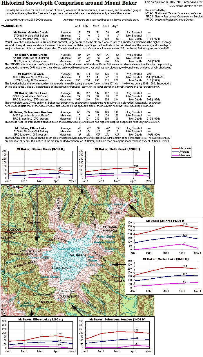
<br><br>I share your fascination. I've studied the rain shadow effects around many Cascade volcanoes including Mt Baker. See the graphic below, which includes a map and snowdepth stats for 6 sites located all around Mt Baker. This was culled from my "Snowdepth Comparison along the Cascade Range" that includes 94 snowdepth sites. The full study can be found near the bottom of my Cascade Snowfall and Snowdepth page (which I desperately need to update with this season's snowpack info, if I can find the time to do so).<br><br> Historical Snowdepth Comparison around Mount Baker (700x1230 GIF, 226 kB)<br><br>I'm fascinated by the different climates that exists over short distances here. Such as, the vast difference in snowpack between Baker ski resort and Heliotrope ridge.
Please Log in or Create an account to join the conversation.
- philfort
-
Topic Author
- User
-
Less
More
- Posts: 259
- Thank you received: 0
20 years 6 months ago #173738
by philfort
Replied by philfort on topic Re: Climate differences over short distances
Glad I gave you something to do  <br><br>I was trusting the elevation of Skookum Creek more than I do the lat/lon. But looking at the aerial photo, there is a road that goes right to that coordinate (not shown on the map), so you're probably right about the elevation (I had assumed it was near the ridge top, which is about 3900ft).<br><br>Your "cold air from stevens pass" theory sounds interesting, although there is perhaps a funnel for cold air via Money Creek and Lake Elizabeth, that could potentially affect Skookum? I've often been suprised how much snow there is in the Money Creek area. And a couple times I've been underwhelmed at the snowpack on the west slope of Persis, which is just across a little valley from AM. I'd be curious how much snow is at 3500ft on Persis. I'd bet less than 30 inches.<br><br>But I'm just guessing here.<br><br>
<br><br>I was trusting the elevation of Skookum Creek more than I do the lat/lon. But looking at the aerial photo, there is a road that goes right to that coordinate (not shown on the map), so you're probably right about the elevation (I had assumed it was near the ridge top, which is about 3900ft).<br><br>Your "cold air from stevens pass" theory sounds interesting, although there is perhaps a funnel for cold air via Money Creek and Lake Elizabeth, that could potentially affect Skookum? I've often been suprised how much snow there is in the Money Creek area. And a couple times I've been underwhelmed at the snowpack on the west slope of Persis, which is just across a little valley from AM. I'd be curious how much snow is at 3500ft on Persis. I'd bet less than 30 inches.<br><br>But I'm just guessing here.<br><br> Please Log in or Create an account to join the conversation.
- pinhead
-
- User
-
Less
More
- Posts: 3
- Thank you received: 0
20 years 6 months ago #173991
by pinhead
Replied by pinhead on topic Re: Climate differences over short distances
The differences in the physical characteristics of the sites could provide a reasonable explanation for the differences in SWE.<br><br>While elevation, orographics, and synoptic-scale weather patterns can influence snow distribution; slope, aspect, wind speed, wind direction, vegetation type, vegetation density, solar radiation, and surface roughness can have a profound influence on snow distribution as well. All of these variables have a complex relationship as they are interrelated and exhibit extreme heterogeneity. In certain areas, elevation has been found to be the most important variable influencing snow distribution; however, other studies have found elevation to be of minor importance. The take home message here is that the effect of elevation can be entirely site specific and there may be other dominant factors controlling snow distribution.<br><br>Alpine Meadows and Skookum Creek are very different in terms of their physical characteristics. Alpine Meadows resides in a small alpine meadow surrounded by old growth. The site has a SW aspect and is very protected (from both wind and solar). On the other hand, Skookum Creek has no vegetation (resides on an old log bed), has a N aspect, and is much more affected by both wind redistribution processes and solar radiation.<br>
Please Log in or Create an account to join the conversation.