- Posts: 464
- Thank you received: 0
Paradise snowdepth reaches triple digits!
- garyabrill
-

- User
-

Less
More
21 years 3 months ago - 21 years 3 months ago #171564
by garyabrill
Replied by garyabrill on topic Re: Paradise snowdepth reaches triple digits!
Visual evidence in the February-March period seemed to indicate that the snow level was much higher than 9000' on Mt. Rainier in the January 23 period. No rime at all was evident on Little Tahoma, 11,117' and rime didn't appear heavy to about 12,000-12,500' in Sunset Ampitheatre and on Sunset Ridge. Gibraltar Rock looked to be heavily rimed only on it's upper part to add confirmation. The sharp difference between bare rock and very heavy rime was very abrupt and obvious up until the recent snows.<br><br>I do believe that the snow level (if there is such a thing in these conditions) was significantly lower on Mt. Baker, perhaps 3-4,000' lower. Only the very summit pinnacle of Shuksan was rimed at that time and BC reports indicated a maximum snow level of up to 2800 m along the south coast, but with two meters of snow accumuating (along with some rain) in that period near Cayoosh Pass above 2200 m.
Please Log in or Create an account to join the conversation.
- Jeff Huber
-
Topic Author
- User
-
Less
More
- Posts: 371
- Thank you received: 0
21 years 3 months ago #171567
by Jeff Huber
Replied by Jeff Huber on topic Re: Paradise snowdepth reaches triple digits!
<br><br>Ron has been a member since 07/18/02, which was 1,003 days ago. Since then he has posted 807 times, averaging .8045 posts per day. Ergo, I'll place my money on Ron reaching 1000 posts on December 11th 2005.My money's on late summer of this year.
Please Log in or Create an account to join the conversation.
- Amar Andalkar
-
- User
-
Less
More
- Posts: 635
- Thank you received: 0
21 years 3 months ago #171568
by Amar Andalkar
Replied by Amar Andalkar on topic Re: Paradise snowdepth reaches triple digits!
<br><br>I don't really know what the relation is between the "rimeline" and the freezing/snow level during a storm. This seems to be a complex relation involving many unknown variables.<br><br>But during the January 16-23 period, the temperature at Paradise never exceeded 45 F while any precip was falling. So even assuming a small saturated lapse rate of 3 F per 1000 ft, this implies a maximum freezing level of 10000 ft (snow level around 9000 ft). It would be quite shocking if the snow level approached 11000-12000 ft under those conditions. Am I missing something in my calculations? The temps did reach 50 F at Paradise a few times in late January, but only on dry days. <br><br>My guess is that by the time visual observations were made in Feb-March, the numerous warm and sunny days had melted off the rime below 12000 ft, especially on the south and west sides of the mountain which were observed.<br>Visual evidence in the February-March period seemed to indicate that the snow level was much higher than 9000' on Mt. Rainier in the January 23 period.<br>. . .
Please Log in or Create an account to join the conversation.
- garyabrill
-
- User
-
Less
More
- Posts: 464
- Thank you received: 0
21 years 3 months ago - 21 years 3 months ago #171571
by garyabrill
Replied by garyabrill on topic Re: Paradise snowdepth reaches triple digits!
Amar,<br><br>I don't think subsequent melting accounted for the lack of rime on Little T, where the evidence was most visible. There just wasn't any rime on Little T at all, indicating wet snow during the storm was above that level. What appears to be heavy rime is often wet snow in the 30-34 degree range. The freezing level at the time of the storm was very evident. The rime on the west end of Rainier, particularly in the Sunset Ampitheatre appeared to be the thickest I've ever seen (or remember seeing).<br><br>Although I use similar temperature interpolations as you do to calculate snow levels, sometimes multiple freezing levels can complicate the calculations. Quillayute soundings might be indicative of some of these inversions, but with the SSW-NNE orientation of the FL in these warm events, Quillayute soundings would probably have been more indicative of freezing levels W of Whistler. There usually appears to be about a 4 to even 6000' freezing level difference E-W across the frontal band. In the same position within the band, the freezing levels are often similar along the entire length of the band. For instance, I don't remember if this was the event, but one Pineapple this winter extended all the way from Hawaii eventually to the NE shore of Hudson's Bay as the band drifted east. So there was rain clear up in northern Ontario with temperatures near 50 degrees. <br><br><br>Edited to add: I couldn't find them but there must be archived soundings available. I would think Salem, Ore FL's would be reasonably predictative of Mt. Rainier in a SSW flow. The same air over Salem would have reached Rainier no more than an hour or two later. Roger's Pass at the time recorded rainfall>2300m, but coastal BC had 2800m rainfall.
Please Log in or Create an account to join the conversation.
- Amar Andalkar
-
- User
-
Less
More
- Posts: 635
- Thank you received: 0
21 years 3 months ago - 21 years 3 months ago #171572
by Amar Andalkar
Replied by Amar Andalkar on topic Re: Paradise snowdepth reaches triple digits!
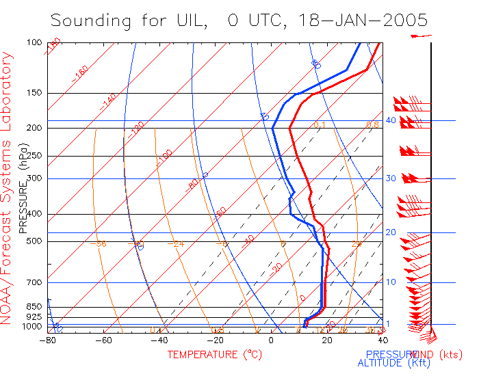
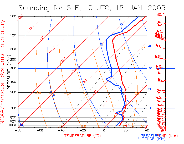
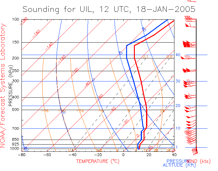
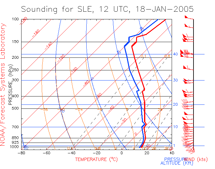
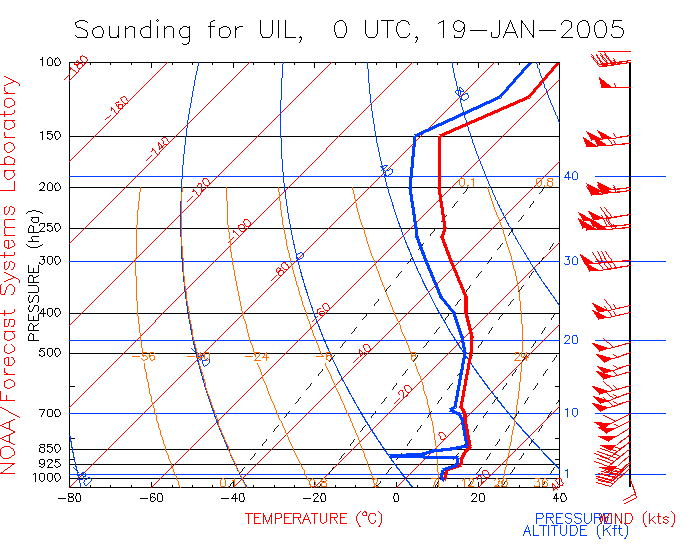
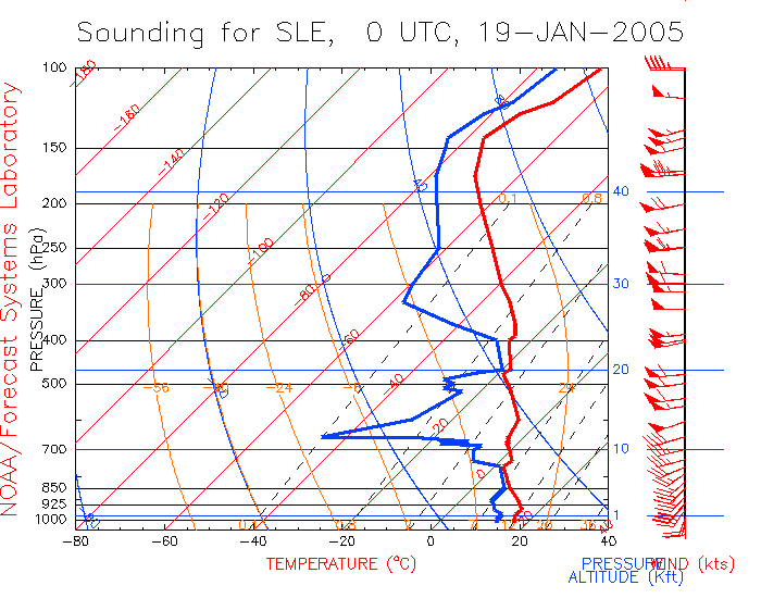
Gary, that's interesting info. An inversion could explain the unusually high FL and riming. Is there someplace to find old archived upper air soundings? The combination of Quillayute and Salem soundings would determine the FL throughout the WA Cascades pretty well, with Salem being more relevant for Rainier during such a system.<br><br>Wait a minute, I've found it at
raob.fsl.noaa.gov/
. Not a user-friendly site at all, but I've managed to generate the relevant plots, covering a 24-hour period centered on the maximum precip intensity of that Pineapple Express:<br><br>
UIL-72797-18-JAN-2005-00UTC.gif
SLE-72694-18-JAN-2005-00UTC.gif
<br>
UIL-72797-18-JAN-2005-12UTC.gif
SLE-72694-18-JAN-2005-12UTC.gif
<br>
UIL-72797-19-JAN-2005-00UTC.gif
SLE-72694-19-JAN-2005-00UTC.gif
<br><br>The most important plots are at 18-JAN-2005-12UTC (4am PST), the real climax of that rain event, which show a near-inversion right at 0 C. Temps don't quite invert, but they do hold almost constant near 0 C from 9-11000 ft at Quillayute (UIL) and 10-12000 ft at Salem (SLE). So it certainly seems plausible that it did rain to over 11000 ft during the height of that storm. The soundings seem to support your rime observations.<br><br>It would be great to have temperature telemetry from Camp Muir to show these kind of effects in real time, with a radio link down to Paradise and the NWAC station there. A temp sensor could be mounted behind one of the huts, with wind speed and direction on top, plus perhaps a radiometer/pyranometer to show when the sun is shining up there above a cloud layer. I guess a webcam up there is way too much to hope for, and too difficult to maintain, but a weather station should be feasible if a small amount of funding can be found. I'm sure this has been considered before.<br><br><br>Edited to add: Gary, I wrote this post before seeing your edit. It's funny that we were both thinking about the Salem sounding data at the same time.<br><br>
Please Log in or Create an account to join the conversation.
- garyabrill
-
- User
-
Less
More
- Posts: 464
- Thank you received: 0
21 years 3 months ago #171634
by garyabrill
Replied by garyabrill on topic Re: Paradise snowdepth reaches triple digits!
Thanks, Amar. The sounding data are indicative. I just read recent freezing levels following a storm from the boundary between dark and snow or rime-covered rock. Since the rock is warm or is warmed quickly in a storm, it is usually an accurate indicator of the freezing level. Trees also indicate this, even in windy storms when dry snow is blown off the trees. There will usually be a line, immediately after a storm, where snow sticks to the trees. Subsequent winds will not blow this snow off. Only melting can remove it.
Please Log in or Create an account to join the conversation.