May 6, 2007, W Esmeralda Pk 6765', Hawkins Mt 7160'
See the May 1, 2004 Tr for the approach description:
https://turns-all-year.com/trip-reports/may-1-2004-hawkins-mountain
To my surprise there was zero snow on the Fish lake Rd. (4330) to the Camp Creek spur (4330-138).
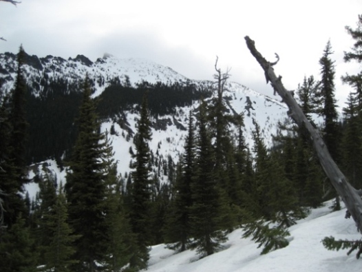
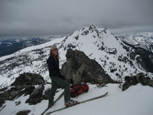
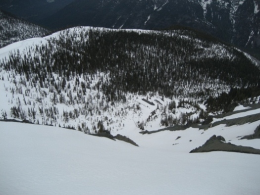
Using my usual approach I was able to put the skis on at just over 4000 ft. Pleasant surprise, by next weekend it will probably be 4400 ft. Snow was firm on the ridge above Camp Cr. (pic 3 shows most of the ridge approach). At 6400 ft I peeled east off the ridge into the big South basin of Hawkins and did a fun fast downward traverse (skins off) to Gallagher Head Lake. Hawkins had been enveloped by a 6800ft. ceiling so I wanted to give it time to burn off. Also, I knew I had time since the Hawkins run is west facing. Then skins back on for the climb to the highest of the Esmeralda Peaks 6765 ft. (pic 2 with Hawkins behind). Snow had only thawed to about 1 inch of corn aided by the persistent cloud cover. The south side of Esmeralda was a 1200 ft. run on nice corn. Skins back on for the diagonal traverse above Gallagher Head Lake to the big saddle between the main summit of Hawkins and the "Thimble". Darn, the ceiling actually dropped to 6400 ft.; after the summit had been out when I was on top of Esmeralda. Not seeing well I picked my way through a steep break in the cornice above the saddle to the top of Hawkins. After 40 min. still no sign of burning off of the fog so I began my descent. Snow was just thawing and quite turnable down the upper west face. Then a rising traverse to the top of the main gully of Camp Creek. This I skied to 5200 ft. and then did a diagonal traverse back to the descending ridge crest. Pic 1 shows the slope off the summit and the gully to far skiers left. Pic 3 shows the top of the gully and the traverse skiers left of the drainage back to the forested ridge crest. Then it was a bit bumpy but fun tree skiing trending NW down the ridge above Camp Creek to 4000ft. and a short hike out to the Fish Lake road.
Would like to do this trip someday with someone who has done it, yours looked like a long tour, but some of the traversing must have saved some energy and time.
In the 2nd picture is your return traverse in line with the persons body just below the steeper peak of Hawkins?
Thanks for sharing and keeping my dream alive.
Joe
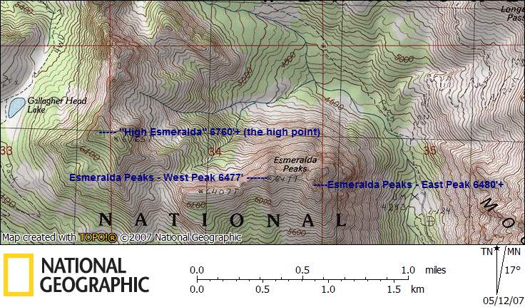
John, I thought I should double check with you on the naming of peaks in the Esmeralda group - in case I still have it wrong! :)
Here's a map with the names as I've been using them. From the CAG, point 6477 is Esmeralda Peaks - West Peak, and the highest of the Esmeralda Peaks is the East Peak at 6480'+. "High Esmeralda" 6760'+ is slightly higher than Point 6765, the name coming from Jeff Howbert's Back Court 100 listing first published in Pack and Paddle some time ago. How do I know this? Someone with the initials J. M. told me! :D
Larry
author=Joedabaker link=topic=7020.msg28284#msg28284 date=1178920851]
In the 2nd picture is your return traverse in line with the persons body just below the steeper peak of Hawkins?
Thanks for sharing and keeping my dream alive.
Joe
Hi Joe,
Yes, directly left of my head, on the flat part of the snowy south ridge, is where you take off. Then go fast diagonally down past my right side just below the cliff band. Retrace by going up to my left ear from Gallagher Head Lake on the return to Hawkins. And the route to the high saddle of Hawkins (not visible in picture) goes up, between my ear and the cliff band, and then on up behind the cliff band. For some reason I love connecting easy peaks on traverses and this is a good one. Head on up!
John
author=Larry_R link=topic=7020.msg28305#msg28305 date=1178985058]
"May 6, 2007 W Esmeralda Pk 6765', Hawkins Mt 7160' "
John, I thought I should double check with you on the naming of peaks in the Esmeralda group - in case I still have it wrong! :)
Here's a map with the names as I've been using them. From the CAG, point 6477 is Esmeralda Peaks - West Peak, and the highest of the Esmeralda Peaks is the East Peak at 6480'+. "High Esmeralda" 6760'+ is slightly higher than Point 6765, the name coming from Jeff Howbert's Back Court 100 listing first published in Pack and Paddle some time ago. How do I know this? Someone with the initials J. M. told me! :D
Larry
Hi Larry,
Yes J.M. was originally correct, and has been putting too much info. on the mental hard drive lately, I think. What I called West Esmeralda has actually become known as "High Esmeralda." Thanks for the catch!
John
Reply to this TR
Please login first: