May 2-4, Pyramid-Snowfield
5/15/08
WA Cascades East Slopes North
3993
7
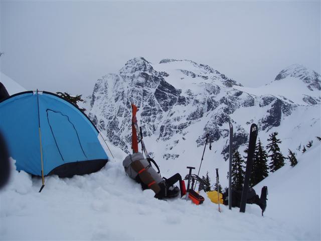
Greg A. and I abandoned an ambitious four day tour from Snoqualmie Pass for a higher elevation destination to get above the rain forcast for Friday and Saturday. Greg suggested the Pyramid approach to Snowfield as described in Rainier B's book. Fortunately it didn't rain Friday, so our approach via Pyramid Lake was dry, however the area suffered a major burn many years back and the resulting forest is dense and unremarkable. Also the last knob to the campsite proved difficult to ascend due to steepness and soft snow. The campsite had great views, though somewhat obscurred by clouds.
The next day had mixed weather, sometimes filtered sun, sometimes snow showers, sometimes both. Travel over the Colonial and Neve' Glaciers was unremarkable, with no sign of crevasses. The high point of our skiable approach got us to the 8100' level on the west side of Snowfield, at a period of maximum cloud density so we decided to bag the summit scramble for a quick return to beat the sluff's from Pyramid that crossed our approach route, in which we were successful.
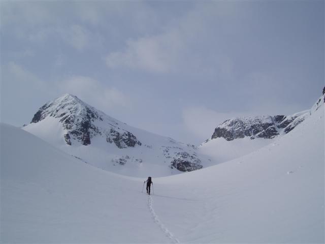
Sunday brought blue bird skies and great views of Colonial and the Pickett's. We decided to descend an open gully descending north of Pyramid. The cliff bands presented some difficulties, but by traversing skiers right through some convoluted terrain we eventually found a tree with enough melt to downclimb the last six feet. Tree climbing with ski's on was a new one for me. We then took a bearing on the east valley wall and cut through the woods until we picked up our up track and it was all good back to the wheels.
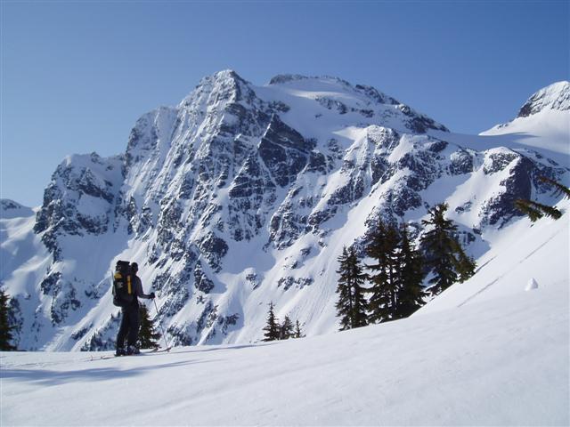
I am always amazed at how big the North Cascades are. I ski mostly in the Snoqualmie area and get to thinking I'm getting the hang of things and doing some pretty good tours, but this trip was humbling, in the amount of energy required, the higher level of avy assessment skills and navigation skills needed. The payoff is the mountains. They are just amazingly complex. Thanks for the good company, Greg. It was a memorable journey
The next day had mixed weather, sometimes filtered sun, sometimes snow showers, sometimes both. Travel over the Colonial and Neve' Glaciers was unremarkable, with no sign of crevasses. The high point of our skiable approach got us to the 8100' level on the west side of Snowfield, at a period of maximum cloud density so we decided to bag the summit scramble for a quick return to beat the sluff's from Pyramid that crossed our approach route, in which we were successful.
Sunday brought blue bird skies and great views of Colonial and the Pickett's. We decided to descend an open gully descending north of Pyramid. The cliff bands presented some difficulties, but by traversing skiers right through some convoluted terrain we eventually found a tree with enough melt to downclimb the last six feet. Tree climbing with ski's on was a new one for me. We then took a bearing on the east valley wall and cut through the woods until we picked up our up track and it was all good back to the wheels.
I am always amazed at how big the North Cascades are. I ski mostly in the Snoqualmie area and get to thinking I'm getting the hang of things and doing some pretty good tours, but this trip was humbling, in the amount of energy required, the higher level of avy assessment skills and navigation skills needed. The payoff is the mountains. They are just amazingly complex. Thanks for the good company, Greg. It was a memorable journey
This is a tour I have wanted to do for a very long time. I have been to the ridge above Pyramid lake but no further. Would you be so kind as to give more details like were you able to ski from the car? Time to camp etc? Is the Neve glacier a worth while destination for skiing? What route did you take to get past Pyramid Peak? Very much appreciated.
author=freeheel4ever link=topic=9983.msg40169#msg40169 date=1210029651]
This is a tour I have wanted to do for a very long time. I have been to the ridge above Pyramid lake but no further. Would you be so kind as to give more details like were you able to ski from the car? Time to camp etc? Is the Neve glacier a worth while destination for skiing? What route did you take to get past Pyramid Peak? Very much appreciated.
What he said. Or she said. In any case, this trip is a frequent discussion amongst my circle and I'm curious as to the details. If you have the stomach for it, would you offer more concerning the descent & the sloughing from Pyramid you note covered your uptrack. Would you choose a different descent next time?
Any info is appreciated, thanks and well done.
More details: I'm thinking it took us 8 hours, more or less to get to to 5,500'. The snow started around 2,000' and we started skiing where the trail crosses the creek coming out of the lake. We gradually worked our way southwest from the lake until we hit the nose of the ridge, then proceeded south. Above 4200' it starts to open up, I'd recommend staying to the n. of the nose through that section to avoid a lot of up and down. The last 800' presented a lot of cliff bands and general steepness. We didn't find any easy way up and it kinda kicked our butts, coming at the end of a long day. We had to endlessly kick turn our way up a steep, narrowing gully for at least 100' to finally gain the top.
The route from the camp to the Colonial Glacier begins about 400' further up and crosses a 30 deg slope above a very serious cliff for about 75-100 yards. The route traverses along, slightly descending for several hundred yards, directly underneath the northeasterly cliff face of Pyramid. We saw that the entire length of that section is subject to releases from above with one major gully a little over half way across. In the morning it was pretty firm, but not the harder freeze of the previous night, so we crossed it, thinking about what the afternoon would bring, especially if there was much sun.
The Neve'-Colonial Col has a nice n. facing slope that had some of the better snow of the trip. The other side is somewhat steeper, but shorter. The ski back from the west slope of Snowfield is only steep at top, then generally mellow, for some lazy turns back. I think the draw for that area is the incredible views south, which were totally veiled in clouds.
We didn't get back before the sun heated the upper slopes of Pyramid, so we watched for awhile and saw that they were pretty small, it looked like most of the major stuff had come down earlier in the week. The sun had moved off the slope above the ramp, so we succumbed to human factors (the desire for hot drinks and food, warm sleeping bags, rest and relaxation, etc.) and maintaining wide separation, made the dash.
To be totally safe in the conditions that were out there last weekend, we probably should have stayed in camp. So if you're thinking of going there, maybe waiting until it corns up and being prepared to wait at the north end of the Colonial Glacier would be something to think about.
Good advice.
Right now we're entering the mushiest period of the spring. There has been a lot of new snow in the past few weeks, with below normal temperatures. When the freezing level shoots up like it did on Sunday, we're going to have a lot of wet slide activity for a while. The rock faces are still holding a lot of snow and they can threaten slopes like the one below Pyramid Peak.
Until the snow becomes more consolidated (which could take until Memorial Day or longer if it keeps snowing) it's a good idea to wait for the cooler part of the day to cross slopes like the one below Pyramid Peak. Eventually things will firm up and you'll be able to cross such slopes at any time of day. But on a warm day during the mush season (right now) you need to be careful.
Yeah, a friend of mine and i schwacked up the colonial creek drainage hoping to avoid the nasty climb up to the pyramid ridge a few weeks ago... We were not too hopeful, as getting up on the colonial glacier from the basin is 'interesting'. However, we saw the largest avalanche i've ever seen come off of pyramid peak right onto the traverse for the standard route - it covered the whole face (i think its 1000' vf or so) for a few seconds, and it was only 10am! It was very avalanche movie esq... We sat in the basin and watched the carnage for a few hours, pretty spectacular - kind of like one of those movies where the sun comes accross the faces, and as the rays touched the snow, everything just went.
pic of traverse from basin:
http://www.flickr.com/photos/spcmanspiff/2450469485/sizes/l/in/set-72157604790463085/
Its a wide angle lense, so pyramid looks smaller than it is... Wouldn't want to get caught in a big slide under that!
pic of traverse from basin:
http://www.flickr.com/photos/spcmanspiff/2450469485/sizes/l/in/set-72157604790463085/
Its a wide angle lense, so pyramid looks smaller than it is... Wouldn't want to get caught in a big slide under that!
Thank you for the picture as it was very informative. How was your route. There doesnt seem to be any good, much less great, approach to this area. Did you press on or call it good at the drainage? I am very interested in any information concerning your trip. Thanks.
There is a climbers trail into the drainage from the colonial creek road crossing, but we hit snow a few hundred feet above the road, covering it - yielding a miserable bushwack traversing a very steep forested slope with snow just weak enough to punch through every few steps - there was even a cliff under much of it into colonial creek. Later in the season, the climbers trail might make this approach more palatable.
I've gotten up to the pyramid col via the pyramid lake trail before mid winter, and it too is no fun as described in this report... They are both slow and steep (although the colonial creek approach is only 1 mile and 1400vf of bushwacking, as opposed to almost 5,000 vf the other way), but I think they pyramid lake approach is safer - the only way up to the colonial glacier via the creek is a steep, exposed traverse which you can see in the right hand side of the photo. When we went up the ridge in march, we skied down the way swooz described for an awsome 2000' powder run before skiing down several waterfalls - TR
http://talk.splitboard.com/viewtopic.php?t=2234&view=next&sid=9fa1f10e547c84fa5b5b924a2500ab38
Reply to this TR
Please login first: