June 1, 2008, Big Snow via Dingford Creek
6/1/08
2180
2
A couple college buddies decided to take a shot at Big Snow Mountain over the weekend despite the questionable weather. A third decided on a whim to join us - even after he spent the Friday before the trip having chemotherapy dripped into his veins. We weren't sure how far we would get.
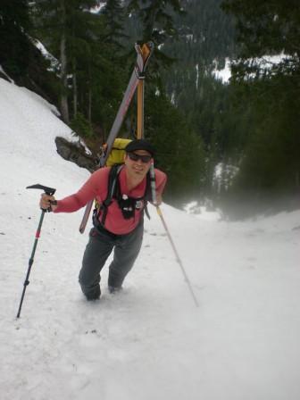
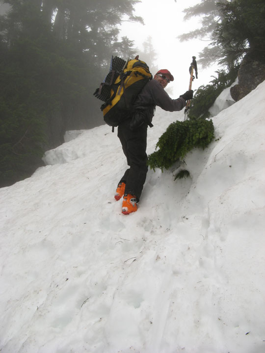
With the Middle Fork road gated at Dingford Creek and the Miller River road reportedly still full of snow, the Dingford Creek trail seemed the best approach. Starting at 1400', "fairly continuous" snow from about 2500 elev on. We ended up leaving skis on packs because of creek crossings, and booted up all 5 1/2 miles to Big Snow Lake, but in retrospect could have skinned much of the valley.
We headed to the outflow chute up to Big Snow Lake direct, and skipped going to Myrtle Lake. The chute was too steep to skin but soft enough to boot without crampons. About 1000' vert and framed by trees and cliffs - very cool. Nice campsites at the lake with views.
Next day, June 1, at the crack of 9 a.m. we booted the 1800 feet up to the summit. Crux of this climb is getting out of camp where you have to scramble up the ridge separating Big Snow and Snowflake lakes through small cliffs and trees. Map would seem to suggest other routes but I have read enough trip reports of this route that indicate the ridge is better. Not too bad, but we got a little damp and I tasted sap the rest of the day. Less than 2 hours up.
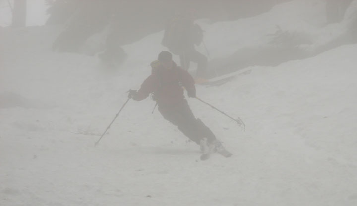
Unfortunately, we were in fog starting half-way to the summit and it stayed that way. Heading down, wide and fairly steep but not scary slopes. Too bad we couldn't see the views. After reaching and packing up camp, we hiked over to the outflow chute. Twenty feet down or so we had to climb over a schrund or crack of some kind which was there the day before but still only 75% across. Possible to ski over it but in the unlikely event of a collapse or fall you could land in a waterfall and then go under the snow pack - very bad. Downclimbing over it to the side was fairly simple and I'm thinking it would still be manageable on the rocks even if the crack finally crosses the width of the entire chute.
The rest of the chute was the best snow on the trip - not as slushy as higher up and a long, sustained pitch with good visibility thanks to the contrast with the trees and cliffs (it was still kinda foggy). Once down in the valley, we were able ski easily to about 3000' elevation making for a 3600' descent for the day. We then "survival skied" for another couple miles and 500' more vertical but it was not that fun - the snow was full of tree gunk and we were soaked going through thickets of small trees. We walked down the last couple miles.
Note for the future: With this snowpack, this is still a good trip as of June 1, but I think 2-3 weeks prior would have been be ideal. Probably OK to do for another couple weeks - certainly the upper slopes. This being an exceptional snow year, it will take some thought to plan for this route in an average snow year with an eye toward decent coverage but low avy danger.
Final note - Murray, you are one strong sonofagun for heading out on this trip while in the middle of chemo. And I'm not sure you still weren't the strongest of us all. Thanks for making the trip all the more fun. Now take it easy!
With the Middle Fork road gated at Dingford Creek and the Miller River road reportedly still full of snow, the Dingford Creek trail seemed the best approach. Starting at 1400', "fairly continuous" snow from about 2500 elev on. We ended up leaving skis on packs because of creek crossings, and booted up all 5 1/2 miles to Big Snow Lake, but in retrospect could have skinned much of the valley.
We headed to the outflow chute up to Big Snow Lake direct, and skipped going to Myrtle Lake. The chute was too steep to skin but soft enough to boot without crampons. About 1000' vert and framed by trees and cliffs - very cool. Nice campsites at the lake with views.
Next day, June 1, at the crack of 9 a.m. we booted the 1800 feet up to the summit. Crux of this climb is getting out of camp where you have to scramble up the ridge separating Big Snow and Snowflake lakes through small cliffs and trees. Map would seem to suggest other routes but I have read enough trip reports of this route that indicate the ridge is better. Not too bad, but we got a little damp and I tasted sap the rest of the day. Less than 2 hours up.
Unfortunately, we were in fog starting half-way to the summit and it stayed that way. Heading down, wide and fairly steep but not scary slopes. Too bad we couldn't see the views. After reaching and packing up camp, we hiked over to the outflow chute. Twenty feet down or so we had to climb over a schrund or crack of some kind which was there the day before but still only 75% across. Possible to ski over it but in the unlikely event of a collapse or fall you could land in a waterfall and then go under the snow pack - very bad. Downclimbing over it to the side was fairly simple and I'm thinking it would still be manageable on the rocks even if the crack finally crosses the width of the entire chute.
The rest of the chute was the best snow on the trip - not as slushy as higher up and a long, sustained pitch with good visibility thanks to the contrast with the trees and cliffs (it was still kinda foggy). Once down in the valley, we were able ski easily to about 3000' elevation making for a 3600' descent for the day. We then "survival skied" for another couple miles and 500' more vertical but it was not that fun - the snow was full of tree gunk and we were soaked going through thickets of small trees. We walked down the last couple miles.
Note for the future: With this snowpack, this is still a good trip as of June 1, but I think 2-3 weeks prior would have been be ideal. Probably OK to do for another couple weeks - certainly the upper slopes. This being an exceptional snow year, it will take some thought to plan for this route in an average snow year with an eye toward decent coverage but low avy danger.
Final note - Murray, you are one strong sonofagun for heading out on this trip while in the middle of chemo. And I'm not sure you still weren't the strongest of us all. Thanks for making the trip all the more fun. Now take it easy!
I'd recognize Murray in far foggier weather -- nice job y'all. Glad you're getting out on some good trips.
Great work!
We did that descent route late season (in boots) on the last half-day of an multi-day traverse starting at Mt. Daniel (via Daniel traverse, Lynch Glacier, Hinman, La Bohn Gap, Alpine Lakes HR and over Big Snow). We too were in fog until we got down to just above Snowflake Lake.
Cool to hear that the outlet chute was skiable. It gets pretty confined and steep (3rd class) in places. I would imagine that the chute does not go in years with less snow cover, or, when it does, there would be high avy risk above Snowflake Lake. This seems like the right year to have done it.
Reply to this TR
Please login first: