July 12-15, 2007, Glacier Peak, South Side Route
7/12/07
WA Cascades West Slopes Central
20136
7
Brief Summary:
Dave Coleman and I skied from the summit of Glacier Peak on July 14 via the south face and the Gerdine and Cool Glaciers. We approached via the North Fork Sauk Trail (lots of blowdown, 40-50 trees, some quite difficult to cross, along with a hazardous crossing of Red Creek) to reach 5900 ft White Pass and then made high camp at 7280 ft Glacier Gap. There was continuous snow above 6200 ft in the White Chuck Glacier basin, with good snow conditions on the route above Glacier Gap and minimal crevasse hazard, but a group of seracs and crevasses were becoming exposed at the 9100 ft Gerdine-Cool saddle. The route was no longer on continuous snow at the 9600 ft saddle north of Disappointment Peak, requiring about 100 ft of traversing across ash and scree, before regaining snow in the south-facing chute which extends to the summit. Total of about 35 miles round trip from the trailhead with about 10500 ft of total gain, for about 4500 vertical ft of ski descent. Incoming poor weather forced us to end our trip one day prematurely, otherwise we were planning to ski on the Suiattle-Honeycomb Glaciers on July 15.
Dave skis off the summit of Glacier Peak, July 14, 2007.
Detailed Report:
Glacier Peak: the most remote wilderness volcano in the Cascade Range, the only major Cascade volcano with no roads sullying its flanks. And all the more remote since the floods of October 2003 cut off the two primary access roads and trails, via the White Chuck and Suiattle River drainages. I had skied the peak only once prior to the floods, on a which reached within a few hundred feet of the summit.
Since the floods, the primary access to Glacier Peak has been via the North Fork Sauk River Trail, which leaves Sloan Creek Campground (2070 ft) on FR 49 and reaches 5900 ft White Pass on the Pacific Crest Trail in about 9 miles. From White Pass, a climbers' trail traverses eastward around White Mtn and then climbs up and over a 6600 ft ridge into the basin of White Chuck Glacier. There are at least 3 different possible routes across the ridge, all of which appear to be used by climbers and none of which are even close to optimal--each one has serious disadvantages as far as I can tell. Once in the basin, the route to Glacier Gap is easy, mostly flat and traversing, and above Glacier Gap the south ridge route itself is also quite gentle and traversing, not a particularly thrilling ski descent. Post-flood, the minimum round trip distance to the summit had grown to 35 miles, versus 22 miles via the White Chuck and Sitkum back in the good old days. And now in 2007, perhaps the minimum distance was 40 miles: FR 49 has been officially closed since May 10 at Lost Creek, 2.5 miles before the trailhead, due to a possibly undermined or unsafe bridge.
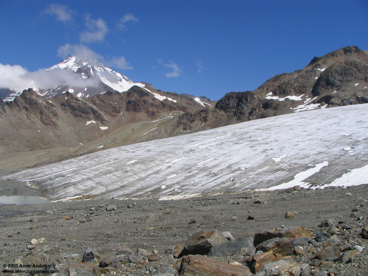
Dave and I had tried this approach in late July 2005, finding the North Fork Sauk Trail in excellent shape, even newly rebuilt in places, but the White Chuck basin was almost devoid of snow and the glacier itself had shrunk to perhaps only 30% of the area shown on the topo map (which is drawn from 1984 photos). What remained of the glacier was mostly bare blue ice at its terminus, with a narrow strip of snow extending up the right edge. The route to the summit was still quite far away and looked mostly bare, so we resigned ourselves to a single 1000-vertical-foot ski run along the remaining glacier and then retreated to our camp at White Pass. The next day my raw, bruised, and bloodied shoulder made for one of the most painful exit hikes I have ever endured. Late July of the worst snow year since 1941 was certainly not an ideal time to haul skis in to Glacier Peak.

Glacier Peak and the remains of the White Chuck Glacier, July 24, 2005.
Fast forward to spring 2007: Dave was very eager to head back to Glacier Peak, especially to spend 4 to 5 days exploring the mountain and skiing various glaciers. I wanted to join him, but fear and apprehension about the long hike and the expected toll (both physical and psychological) that it would take on me caused me to delay and be noncommittal. Finding any other partners for such an expedition proved difficult, though. The weather rarely cooperated either, but at least I was getting stronger and lighter by the day, and eventually I was in good enough shape to at least consider enduring the expected torture. Meanwhile, a brief weather window had allowed Lowell Skoog to launch a . When my shoulder hurt again during the hike out, it meant more delay and rest for the next few days. And meanwhile lots of ongoing shopping: a new lighter pack, lighter hiking boots, lighter harness, lighter carabiners, lighter stove, every possible effort made to lighten my Glacier Peak load without sacrificing any margin of safety. Finally, by July 10, I could delay no more and committed to leaving the next morning. Except that Wednesday, July 11, was forecast to be the hottest day of the year, 95+ in Seattle, and definitely NOT the best day to make a long hike with heavy packs. So the final plan fell into place: we'd leave town Wednesday evening, car camp at the Sloan Creek trailhead, start hiking early morning Thursday to beat the heat, and try to reach Glacier Gap (13+ miles) in a day. Spend 4 nights at Glacier Gap, with at least 1 summit day, and ski/explore various glaciers on other days. As I left the house, I optimistically weighed my new lighter pack with its (partly new and lighter) contents, only to be disappointed by what I saw: 43 lbs, including 11 lbs of food (17500 calories) for 5+ days. Not very light at all, considering that another 16 lbs of skis/boots/skins, plus a couple of items of outerwear, camera, and 1.5 L of water, would put the beast over 65 lbs for sure. We'd also decided to bring along a tent at the last minute, since the forecast had deteriorated somewhat and now called for a chance of thunderstorms Thursday-Friday, thus adding 7 more lbs to our total burden.
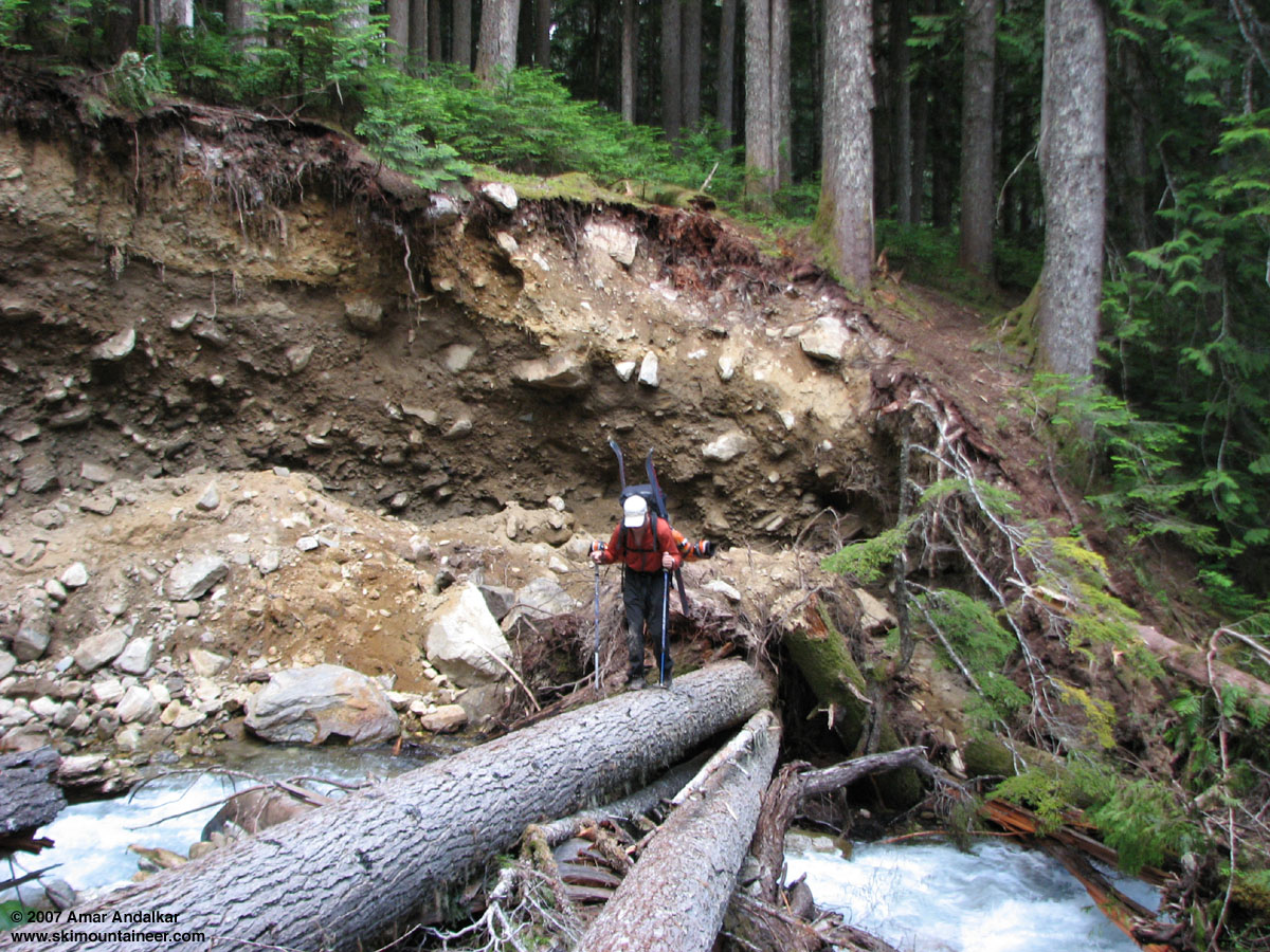
I started hiking from the trailhead at 7 AM Thursday while Dave handled the car shuttle, planning to jog back the 2.5 miles to the trailhead, and then catch up to me. (Another car was parked overnight at the trailhead, unticketed, so it appears that the Forest Service may not be taking action against those who park past the road closure--but we decided not to risk it.) The numerous downed trees added much time and effort to the hike, and the crossing of Red Creek about 4 miles in caused additional pause. Luckily the creek is bridged by 3 solid parallel fallen trees, but the eastern bank is washed out, severely eroded and undercut. The two visible routes up/around it are either a direct ascent of 20 ft along the overhanging undercut sod clinging to the right edge of the washout, or a 100 ft traverse left along the creek's edge on a small (0-1 ft wide) shelf at water level exposed to rockfall from the overhanging eroded 20-ft high cliff, followed by a much easier ascent up an uneroded part of the bank to the left of the washout. We chose the latter and made it through without incident.

Dave crossing Red Creek on the way back, July 15, 2007.
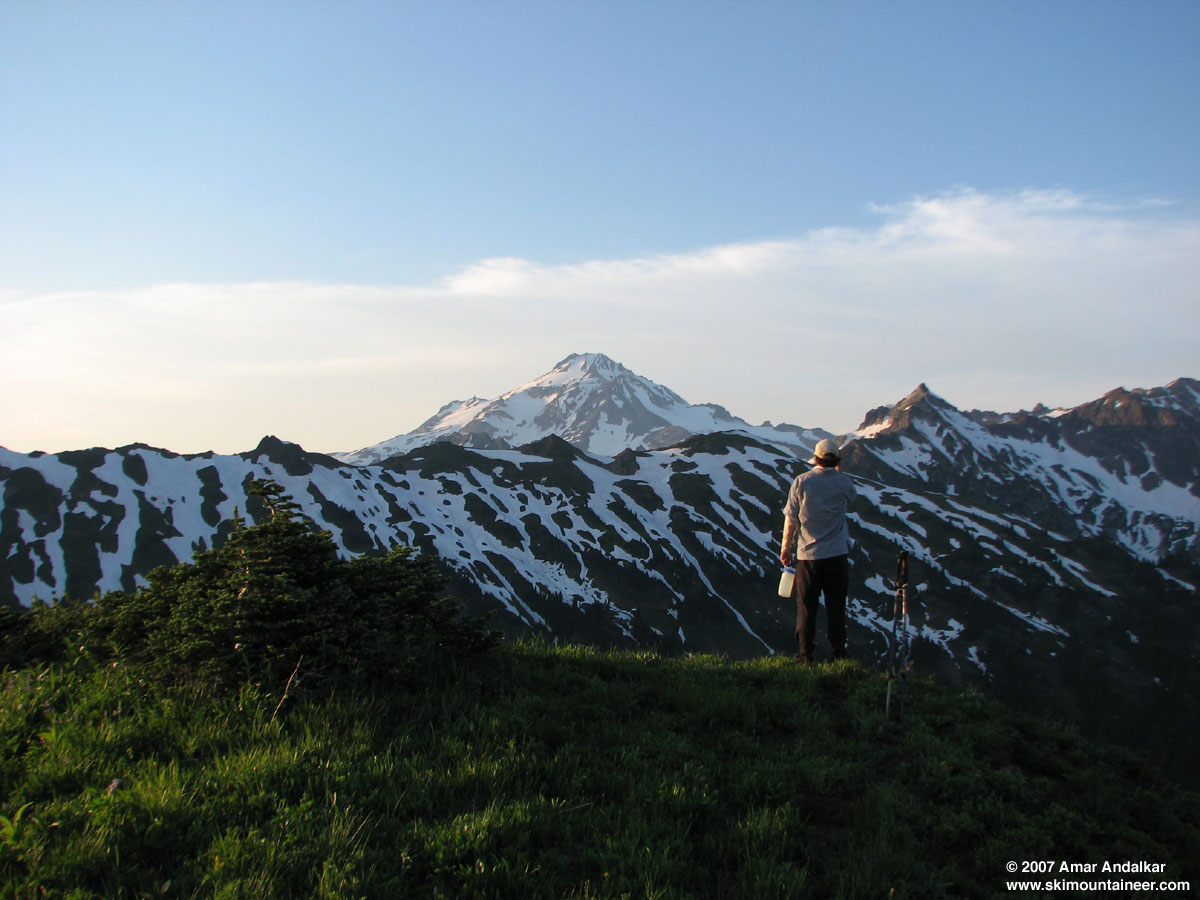
Soon Dave's back was killing him with the extra weight of the tent, especially on the steep switchbacks after Mackinaw shelter at 5 miles. I took the tent for a while, but 1000 vertical ft of forced marching on the uppermost switchbacks was all I could endure with the now 72 lbs of burden (over 50% of my body weight). Dave carried the tent in his hands after that, and we limped into White Pass around 3 PM and set up camp, with hopes of reaching Glacier Gap the first day dashed by our heavy loads. The last part of the traverse to White Pass had crossed several steep gullies still filled with steep and undercut snow, requiring care to cross safely. Thunderstorms danced in the distance above Sloan Peak and the Monte Cristo range, but we escaped with only a few raindrops hitting us. By late evening, the skies had cleared beautifully, so after dinner we hiked south a half-mile along the PCT and climbed Point 6203 to enjoy a fine sunset view of Glacier Peak and the upper part of our planned route (Glacier Peak is not visible at all from White Pass).

Evening hike to Point 6203, July 12, 2007.
The next morning we awoke lazily, since the 4.5 miles to Glacier Gap would make an easy day, even with the required ups-and-downs. Thunderstorms had re-formed all around to the south and west, but conditions nearby seemed OK to risk breaking camp and loading up the packs. By 10 AM, we were ready to march, but just then the storms began to rapidly close in. Clouds poured with astonishing speed over the ridges to the west and into the Sauk drainage, while strong winds began to whip around. We had only minutes to pull the tent back out and set it up in a more protected spot, sheltered by a stand of trees atop the otherwise exposed pass, before the skies opened and wind-driven rain began to pummel us. It certainly looked like the whole trip might be in jeopardy as we settled into the tent to wait out the storm.

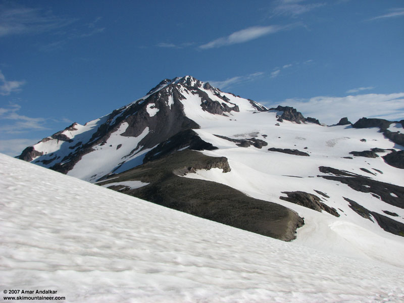
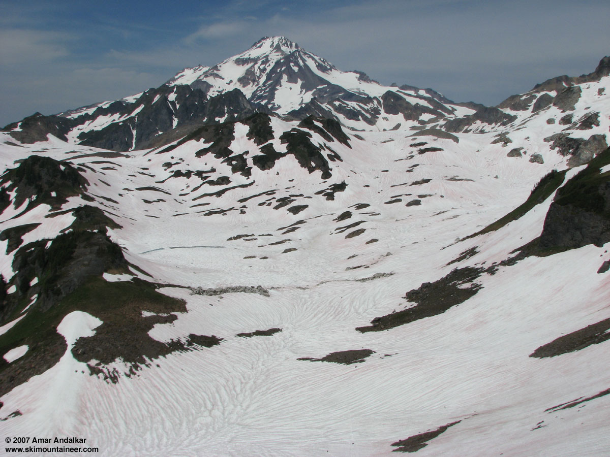
Glacier Peak and lower White Chuck basin from the ridge crossing, July 13, 2007.
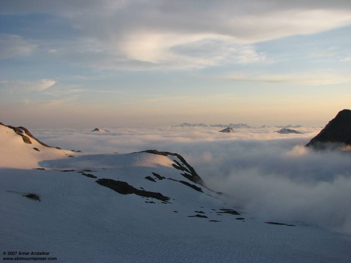
Ninety minutes later, the winds had calmed and the skies had brightened, so I exited the tent into the brilliant sunshine. Just minutes later I was shocked to see a group of eight climbers march up the PCT from the south, planning to climb the same route as us on Glacier Peak. They had come in via Little Wenatchee River and camped farther south along the PCT, with a total of 13 miles to reach White Pass; a longer approach, but it starts 1000 ft higher and is probably easier now than the North Fork Sauk given current trail conditions. We re-packed our camp and followed about an hour behind them, crossing the 6600 ft ridge just right of the "pointy peak"--not a great route it turned out, since 100 ft of very steep grass or loose dirt had to be descended to reach snow on the north side. We skied down to 6200 ft and switched to skins. The rest of the route across White Chuck Glacier basin to Glacier Gap was uneventful, with only a few zig-zags and minor detours needed to remain on continuous snow through the numerous moraines and small lakes of the recently deglaciated basin. Glacier Gap is situated on the divide between the Suiattle Glacier and what was the northern lobe of the White Chuck Glacier, with several nice tent sites and plentiful running water at this time of year. That evening, a strong marine layer built up to the west, eventually filling all the valleys to 6000 ft and then even to 7000 ft, with tendrils of fog just reaching the edge of our camp. But thankfully, we remained in the clear and enjoyed a fine sunset above the sea of clouds.

Looking west from Glacier Gap across the sea of clouds, July 13, 2007.
With only a short 3300 ft to go to the summit, we left camp on foot quite leisurely the next morning, around 8 AM. The standard route climbs a short slope to a 7520 ft saddle just north of camp (east of Point 7739) and then drops 200 ft down the north side, but a much better route on skis would be to follow a near-level traverse along the uncrevassed edge of the Suiattle to avoid the needless up and down. The next couple of miles follows near the crest of Gerdine Ridge, with a few sections of very steep snow traverses which can be easily circumvented by hiking an easy climbers' trail along the bare ridge instead.
Glacier Peak and route up Gerdine Ridge, as seen from the 7520 ft saddle just north of camp, July 14, 2007. (see also
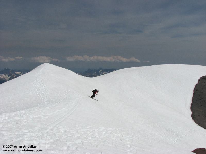
Dave skis the south-facing summit chute, July 14, 2007.
The ski down was better than expected, the over-softened snow in the south-facing chute was stable and easy to ski. I decided to just ski across the scree and ash at the saddle to reach the Cool Glacier, since I prefer not to remove the skis to cross snow-free areas. The Cool and Gerdine Glaciers offered the best turns of the day, wide open GS cruising on decent corn snow. We traversed around to the Suiattle on the lowest part of the descent, reaching 7100 ft just east of Glacier Gap and then skinning the gentle slope for a few minutes back up to camp by 3 PM. A relaxed evening was spent reading and napping, and also trying to eat as much as possible in an effort to finish most of our food before the hike out. We settled on a plan to ski the Suiattle and Honeycomb Glaciers the next day (Sunday), planning a moderate loop which would skin to Point 8197, ski east down the Honeycomb, then skin back to camp via the gap north of Point 7941. Hopefully we'd have enough energy left afterwards to break camp and descend to White Pass, leaving a more manageable hike out for Monday.
We awoke the next morning to cool grey skies, occasional spitting raindrops, and disappointment. It just didn't seem worth wandering around on glaciers in a possible whiteout, so we decided to pull the plug and just do the whole hike out that day. By the time we packed up camp, the skies had improved to partly sunny and it looked like a beautiful day, but it was too late to change plans. We skied out and down, traversing most of the rolls in the White Chuck basin without skins. We chose the easiest gap in the ridge for our return, the gap NE of Point 6770, but even this route has the disadvantage of requiring a second short steep ascent of the east flank of Point 6770 after crossing the main ridge crest. We skied our last few hundred feet down to the climbers's trail and traversed on foot back to White Pass. We switched out of our ski boots, rested, lunched, and felt pretty good for the hike out, but the remaining 9 miles to the trailhead would eventually become quite painful and slow for me, with many long breaks resulting in reaching Sloan Creek around 9 PM in the fading light of the day. Dave arrived with the car shuttle only 15 minutes after I reached the trailhead. At least the hike out this time was 10 times less painful than 2 years ago.

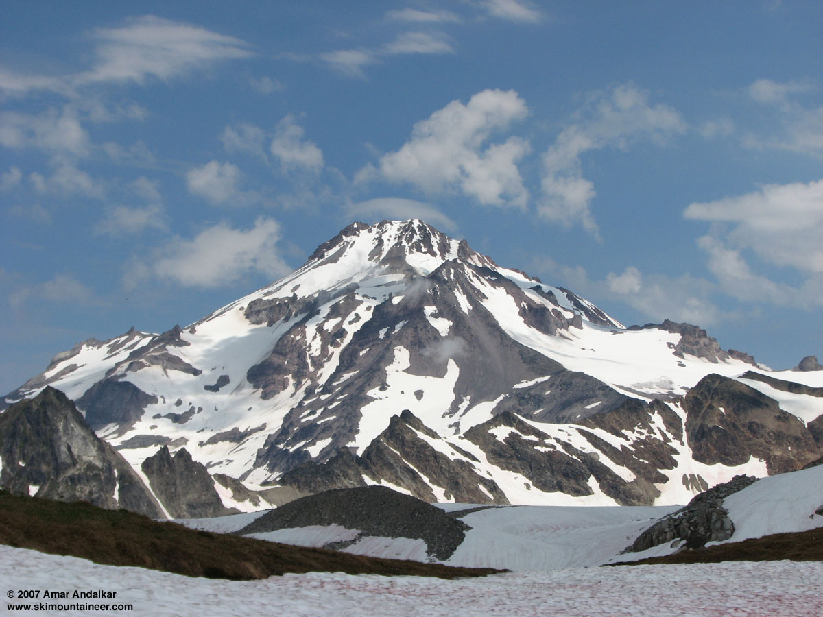
Our final view of Glacier Peak, back in the beautiful sunshine, from the ridge crossing, July 15, 2007.
A successful trip overall, and I was certainly happy to have skied Glacier Peak again especially given the thunderstorms which appeared to have doomed the trip two days earlier, but a bit disappointing nonetheless for having missed out on so much of the exploration we had hoped for. I guess we'll just have to go back next spring, earlier and with lighter weight, as long as the weather cooperates and the trail (some trail, any trail) still exists. Given that 4 years have passed since the 2003 floods with almost no progress on repairing the White Chuck, Suiattle, or Pacific Crest Trails (or their access roads), it seems unlikely that the Forest Service will ever manage to restore full access to Glacier Peak before additional floods destroy it all again.
Dave Coleman and I skied from the summit of Glacier Peak on July 14 via the south face and the Gerdine and Cool Glaciers. We approached via the North Fork Sauk Trail (lots of blowdown, 40-50 trees, some quite difficult to cross, along with a hazardous crossing of Red Creek) to reach 5900 ft White Pass and then made high camp at 7280 ft Glacier Gap. There was continuous snow above 6200 ft in the White Chuck Glacier basin, with good snow conditions on the route above Glacier Gap and minimal crevasse hazard, but a group of seracs and crevasses were becoming exposed at the 9100 ft Gerdine-Cool saddle. The route was no longer on continuous snow at the 9600 ft saddle north of Disappointment Peak, requiring about 100 ft of traversing across ash and scree, before regaining snow in the south-facing chute which extends to the summit. Total of about 35 miles round trip from the trailhead with about 10500 ft of total gain, for about 4500 vertical ft of ski descent. Incoming poor weather forced us to end our trip one day prematurely, otherwise we were planning to ski on the Suiattle-Honeycomb Glaciers on July 15.
Dave skis off the summit of Glacier Peak, July 14, 2007.
Detailed Report:
Glacier Peak: the most remote wilderness volcano in the Cascade Range, the only major Cascade volcano with no roads sullying its flanks. And all the more remote since the floods of October 2003 cut off the two primary access roads and trails, via the White Chuck and Suiattle River drainages. I had skied the peak only once prior to the floods, on a which reached within a few hundred feet of the summit.
Since the floods, the primary access to Glacier Peak has been via the North Fork Sauk River Trail, which leaves Sloan Creek Campground (2070 ft) on FR 49 and reaches 5900 ft White Pass on the Pacific Crest Trail in about 9 miles. From White Pass, a climbers' trail traverses eastward around White Mtn and then climbs up and over a 6600 ft ridge into the basin of White Chuck Glacier. There are at least 3 different possible routes across the ridge, all of which appear to be used by climbers and none of which are even close to optimal--each one has serious disadvantages as far as I can tell. Once in the basin, the route to Glacier Gap is easy, mostly flat and traversing, and above Glacier Gap the south ridge route itself is also quite gentle and traversing, not a particularly thrilling ski descent. Post-flood, the minimum round trip distance to the summit had grown to 35 miles, versus 22 miles via the White Chuck and Sitkum back in the good old days. And now in 2007, perhaps the minimum distance was 40 miles: FR 49 has been officially closed since May 10 at Lost Creek, 2.5 miles before the trailhead, due to a possibly undermined or unsafe bridge.
Dave and I had tried this approach in late July 2005, finding the North Fork Sauk Trail in excellent shape, even newly rebuilt in places, but the White Chuck basin was almost devoid of snow and the glacier itself had shrunk to perhaps only 30% of the area shown on the topo map (which is drawn from 1984 photos). What remained of the glacier was mostly bare blue ice at its terminus, with a narrow strip of snow extending up the right edge. The route to the summit was still quite far away and looked mostly bare, so we resigned ourselves to a single 1000-vertical-foot ski run along the remaining glacier and then retreated to our camp at White Pass. The next day my raw, bruised, and bloodied shoulder made for one of the most painful exit hikes I have ever endured. Late July of the worst snow year since 1941 was certainly not an ideal time to haul skis in to Glacier Peak.
Glacier Peak and the remains of the White Chuck Glacier, July 24, 2005.
Fast forward to spring 2007: Dave was very eager to head back to Glacier Peak, especially to spend 4 to 5 days exploring the mountain and skiing various glaciers. I wanted to join him, but fear and apprehension about the long hike and the expected toll (both physical and psychological) that it would take on me caused me to delay and be noncommittal. Finding any other partners for such an expedition proved difficult, though. The weather rarely cooperated either, but at least I was getting stronger and lighter by the day, and eventually I was in good enough shape to at least consider enduring the expected torture. Meanwhile, a brief weather window had allowed Lowell Skoog to launch a . When my shoulder hurt again during the hike out, it meant more delay and rest for the next few days. And meanwhile lots of ongoing shopping: a new lighter pack, lighter hiking boots, lighter harness, lighter carabiners, lighter stove, every possible effort made to lighten my Glacier Peak load without sacrificing any margin of safety. Finally, by July 10, I could delay no more and committed to leaving the next morning. Except that Wednesday, July 11, was forecast to be the hottest day of the year, 95+ in Seattle, and definitely NOT the best day to make a long hike with heavy packs. So the final plan fell into place: we'd leave town Wednesday evening, car camp at the Sloan Creek trailhead, start hiking early morning Thursday to beat the heat, and try to reach Glacier Gap (13+ miles) in a day. Spend 4 nights at Glacier Gap, with at least 1 summit day, and ski/explore various glaciers on other days. As I left the house, I optimistically weighed my new lighter pack with its (partly new and lighter) contents, only to be disappointed by what I saw: 43 lbs, including 11 lbs of food (17500 calories) for 5+ days. Not very light at all, considering that another 16 lbs of skis/boots/skins, plus a couple of items of outerwear, camera, and 1.5 L of water, would put the beast over 65 lbs for sure. We'd also decided to bring along a tent at the last minute, since the forecast had deteriorated somewhat and now called for a chance of thunderstorms Thursday-Friday, thus adding 7 more lbs to our total burden.
I started hiking from the trailhead at 7 AM Thursday while Dave handled the car shuttle, planning to jog back the 2.5 miles to the trailhead, and then catch up to me. (Another car was parked overnight at the trailhead, unticketed, so it appears that the Forest Service may not be taking action against those who park past the road closure--but we decided not to risk it.) The numerous downed trees added much time and effort to the hike, and the crossing of Red Creek about 4 miles in caused additional pause. Luckily the creek is bridged by 3 solid parallel fallen trees, but the eastern bank is washed out, severely eroded and undercut. The two visible routes up/around it are either a direct ascent of 20 ft along the overhanging undercut sod clinging to the right edge of the washout, or a 100 ft traverse left along the creek's edge on a small (0-1 ft wide) shelf at water level exposed to rockfall from the overhanging eroded 20-ft high cliff, followed by a much easier ascent up an uneroded part of the bank to the left of the washout. We chose the latter and made it through without incident.
Dave crossing Red Creek on the way back, July 15, 2007.
Soon Dave's back was killing him with the extra weight of the tent, especially on the steep switchbacks after Mackinaw shelter at 5 miles. I took the tent for a while, but 1000 vertical ft of forced marching on the uppermost switchbacks was all I could endure with the now 72 lbs of burden (over 50% of my body weight). Dave carried the tent in his hands after that, and we limped into White Pass around 3 PM and set up camp, with hopes of reaching Glacier Gap the first day dashed by our heavy loads. The last part of the traverse to White Pass had crossed several steep gullies still filled with steep and undercut snow, requiring care to cross safely. Thunderstorms danced in the distance above Sloan Peak and the Monte Cristo range, but we escaped with only a few raindrops hitting us. By late evening, the skies had cleared beautifully, so after dinner we hiked south a half-mile along the PCT and climbed Point 6203 to enjoy a fine sunset view of Glacier Peak and the upper part of our planned route (Glacier Peak is not visible at all from White Pass).
Evening hike to Point 6203, July 12, 2007.
The next morning we awoke lazily, since the 4.5 miles to Glacier Gap would make an easy day, even with the required ups-and-downs. Thunderstorms had re-formed all around to the south and west, but conditions nearby seemed OK to risk breaking camp and loading up the packs. By 10 AM, we were ready to march, but just then the storms began to rapidly close in. Clouds poured with astonishing speed over the ridges to the west and into the Sauk drainage, while strong winds began to whip around. We had only minutes to pull the tent back out and set it up in a more protected spot, sheltered by a stand of trees atop the otherwise exposed pass, before the skies opened and wind-driven rain began to pummel us. It certainly looked like the whole trip might be in jeopardy as we settled into the tent to wait out the storm.
Glacier Peak and lower White Chuck basin from the ridge crossing, July 13, 2007.
Ninety minutes later, the winds had calmed and the skies had brightened, so I exited the tent into the brilliant sunshine. Just minutes later I was shocked to see a group of eight climbers march up the PCT from the south, planning to climb the same route as us on Glacier Peak. They had come in via Little Wenatchee River and camped farther south along the PCT, with a total of 13 miles to reach White Pass; a longer approach, but it starts 1000 ft higher and is probably easier now than the North Fork Sauk given current trail conditions. We re-packed our camp and followed about an hour behind them, crossing the 6600 ft ridge just right of the "pointy peak"--not a great route it turned out, since 100 ft of very steep grass or loose dirt had to be descended to reach snow on the north side. We skied down to 6200 ft and switched to skins. The rest of the route across White Chuck Glacier basin to Glacier Gap was uneventful, with only a few zig-zags and minor detours needed to remain on continuous snow through the numerous moraines and small lakes of the recently deglaciated basin. Glacier Gap is situated on the divide between the Suiattle Glacier and what was the northern lobe of the White Chuck Glacier, with several nice tent sites and plentiful running water at this time of year. That evening, a strong marine layer built up to the west, eventually filling all the valleys to 6000 ft and then even to 7000 ft, with tendrils of fog just reaching the edge of our camp. But thankfully, we remained in the clear and enjoyed a fine sunset above the sea of clouds.
Looking west from Glacier Gap across the sea of clouds, July 13, 2007.
With only a short 3300 ft to go to the summit, we left camp on foot quite leisurely the next morning, around 8 AM. The standard route climbs a short slope to a 7520 ft saddle just north of camp (east of Point 7739) and then drops 200 ft down the north side, but a much better route on skis would be to follow a near-level traverse along the uncrevassed edge of the Suiattle to avoid the needless up and down. The next couple of miles follows near the crest of Gerdine Ridge, with a few sections of very steep snow traverses which can be easily circumvented by hiking an easy climbers' trail along the bare ridge instead.
Glacier Peak and route up Gerdine Ridge, as seen from the 7520 ft saddle just north of camp, July 14, 2007. (see also
<br /><br />We switched to skis and skins at 8400 ft on the edge of the Gerdine Glacier and traversed across to the 9100 ft Gerdine-Cool saddle. Despite several open crevasses near the Gerdine-Cool saddle, we kept the glacier gear in our packs, although parties on foot were mostly roping up. We skinned the gentle slopes of the Cool Glacier around left to the 9600 ft saddle north of Disappointment Peak. The ridge had melted bare here in the recent heat, requiring about 100 ft of traversing across ash and scree, before regaining snow in the south-facing chute which extends to the summit. We put the skis on our packs and postholed up the softening mush in the chute to reach the summit just after noon, surrounded by large numbers of migrating butterflies. Just as in 2002, a wind-deposited ridge of snow extending NE from the summit reached 10-20 ft higher than the summit rocks which held the register and USGS marker. Excellent views from the ridge, looking down into the eroded summit crater and down the crevassed expanses of the Cool and Chocolate Glaciers to the east. A total of 19 other climbers would summit that day, 2 teams of 8 plus a group of 3, making for quite a busy day on such a remote summit.<br /><br /><img src=)
Dave skis the south-facing summit chute, July 14, 2007.
The ski down was better than expected, the over-softened snow in the south-facing chute was stable and easy to ski. I decided to just ski across the scree and ash at the saddle to reach the Cool Glacier, since I prefer not to remove the skis to cross snow-free areas. The Cool and Gerdine Glaciers offered the best turns of the day, wide open GS cruising on decent corn snow. We traversed around to the Suiattle on the lowest part of the descent, reaching 7100 ft just east of Glacier Gap and then skinning the gentle slope for a few minutes back up to camp by 3 PM. A relaxed evening was spent reading and napping, and also trying to eat as much as possible in an effort to finish most of our food before the hike out. We settled on a plan to ski the Suiattle and Honeycomb Glaciers the next day (Sunday), planning a moderate loop which would skin to Point 8197, ski east down the Honeycomb, then skin back to camp via the gap north of Point 7941. Hopefully we'd have enough energy left afterwards to break camp and descend to White Pass, leaving a more manageable hike out for Monday.
We awoke the next morning to cool grey skies, occasional spitting raindrops, and disappointment. It just didn't seem worth wandering around on glaciers in a possible whiteout, so we decided to pull the plug and just do the whole hike out that day. By the time we packed up camp, the skies had improved to partly sunny and it looked like a beautiful day, but it was too late to change plans. We skied out and down, traversing most of the rolls in the White Chuck basin without skins. We chose the easiest gap in the ridge for our return, the gap NE of Point 6770, but even this route has the disadvantage of requiring a second short steep ascent of the east flank of Point 6770 after crossing the main ridge crest. We skied our last few hundred feet down to the climbers's trail and traversed on foot back to White Pass. We switched out of our ski boots, rested, lunched, and felt pretty good for the hike out, but the remaining 9 miles to the trailhead would eventually become quite painful and slow for me, with many long breaks resulting in reaching Sloan Creek around 9 PM in the fading light of the day. Dave arrived with the car shuttle only 15 minutes after I reached the trailhead. At least the hike out this time was 10 times less painful than 2 years ago.
Our final view of Glacier Peak, back in the beautiful sunshine, from the ridge crossing, July 15, 2007.
A successful trip overall, and I was certainly happy to have skied Glacier Peak again especially given the thunderstorms which appeared to have doomed the trip two days earlier, but a bit disappointing nonetheless for having missed out on so much of the exploration we had hoped for. I guess we'll just have to go back next spring, earlier and with lighter weight, as long as the weather cooperates and the trail (some trail, any trail) still exists. Given that 4 years have passed since the 2003 floods with almost no progress on repairing the White Chuck, Suiattle, or Pacific Crest Trails (or their access roads), it seems unlikely that the Forest Service will ever manage to restore full access to Glacier Peak before additional floods destroy it all again.
This is better than War and Peace and slightly shorter ;)
Glacier Peak in on my list for next spring! Thanks for the excellent (as always) trip report!
BTW are you still planning to publish the Ring of Fire guidebook?
Glacier Peak in on my list for next spring! Thanks for the excellent (as always) trip report!
BTW are you still planning to publish the Ring of Fire guidebook?
Thanks for the report!
Nice report, Amar! I read it with nostalgia, even though it's only been a couple months since I was up there.
And thanks for the geography lesson. I never noticed that the glacier below Disappointment Peak is called the Gerdine. I've been calling it part of the Suiattle Glacier. Oops!
And thanks for the geography lesson. I never noticed that the glacier below Disappointment Peak is called the Gerdine. I've been calling it part of the Suiattle Glacier. Oops!
Thanks for report and great pics Amar. Glad you got up there with the good weather. Nice use of the thumbnails!
Well done Amar! Sounds like quite an adventure!
Thanks everyone for the kind comments.
I'm planning to complete the Skiing the Cascade Volcanoes book (which includes 28 volcanoes in BC, WA, OR, and CA) later this year. It currently exists as a 310+ page fully-formatted (but still incomplete) PDF file. However, I've planned to complete the book a couple of times before (2003, 2005) and not yet gotten it done, so we'll see what happens... The full Ring of Fire guidebook is more of a lifetime project, with no certain timeline or even plan for completion.
The Gerdine Glacier is one of many WA glaciers (dozens, I think) which are named in the Beckey Bible, but which still have no official USGS / USBGN name. I'm not sure if Beckey just never submitted the names to the USBGN for official consideration, or if he did submit them and they got rejected, or what. It would be interesting to find out. Maybe just by asking him?
By the way Lowell, we were very impressed with the fact that you completed this route as a 2-day trip. How light did you go? Were all three of you in one Beta Light with no bivy sacks? Obviously it helps to have enough snow on part of the approach to get the weight of skis/boots off your back. Your report says you "were able to ski most of the traverse from White Pass to the trail switchbacks above Mackinaw Shelter" on the way out, but did you also skin this steep sidehill traverse on the way in, or remain on foot? Which gap did you go through on the ridge extending east from White Mountain?
author=runningclouds link=topic=7611.msg30408#msg30408 date=1185078057]
BTW are you still planning to publish the Ring of Fire guidebook?
I'm planning to complete the Skiing the Cascade Volcanoes book (which includes 28 volcanoes in BC, WA, OR, and CA) later this year. It currently exists as a 310+ page fully-formatted (but still incomplete) PDF file. However, I've planned to complete the book a couple of times before (2003, 2005) and not yet gotten it done, so we'll see what happens... The full Ring of Fire guidebook is more of a lifetime project, with no certain timeline or even plan for completion.
author=Lowell_Skoog link=topic=7611.msg30415#msg30415 date=1185160064]
And thanks for the geography lesson. I never noticed that the glacier below Disappointment Peak is called the Gerdine. I've been calling it part of the Suiattle Glacier. Oops!
The Gerdine Glacier is one of many WA glaciers (dozens, I think) which are named in the Beckey Bible, but which still have no official USGS / USBGN name. I'm not sure if Beckey just never submitted the names to the USBGN for official consideration, or if he did submit them and they got rejected, or what. It would be interesting to find out. Maybe just by asking him?
By the way Lowell, we were very impressed with the fact that you completed this route as a 2-day trip. How light did you go? Were all three of you in one Beta Light with no bivy sacks? Obviously it helps to have enough snow on part of the approach to get the weight of skis/boots off your back. Your report says you "were able to ski most of the traverse from White Pass to the trail switchbacks above Mackinaw Shelter" on the way out, but did you also skin this steep sidehill traverse on the way in, or remain on foot? Which gap did you go through on the ridge extending east from White Mountain?
author=Amar Andalkar link=topic=7611.msg30424#msg30424 date=1185223392]
By the way Lowell, we were very impressed with the fact that you completed this route as a 2-day trip. How light did you go? Were all three of you in one Beta Light with no bivy sacks? Obviously it helps to have enough snow on part of the approach to get the weight of skis/boots off your back. Your report says you "were able to ski most of the traverse from White Pass to the trail switchbacks above Mackinaw Shelter" on the way out, but did you also skin this steep sidehill traverse on the way in, or remain on foot? Which gap did you go through on the ridge extending east from White Mountain?
David and I slept under the Beta Light. I brought no bivi sack. As I recall, David had a bivi sack since he originally planned to sleep outside. Tom (Wenatchee hardman) slept in his bivi sack out in the wind.
I went as light as I could, cramming into my usual ski touring day pack. David and Tom were not quite as fanatical, but they went reasonably light too. I was using one of those super light Western Mountaineering down sleeping bags (about 1 lb.), had no down parka or heavy fleece, and so on. Also, we brought no climbing rope or harnesses. We figured we could avoid glacier hazards by careful route finding.
I brought my strap-on climbing skins on the trip, because I was expecting pollen. Because these skins don't traverse hard snow well, I walked a good bit of the ascending traverse toward White Pass. As I remember, David and Tom skinned most of it. On the way down we were able to ski most of it. We were quite lucky in that regard. (When Paul Ekman and I skied through here in April on the way to Stevens Pass, we skied all the way from Mackinaw Shelter to White Pass.)
On the ridge between White Mountain and Point 6770ft (to the east) we crossed at roughly the half-way point. On the 7.5min topo, there is a closed 6600ft contour right about there. I believe we crossed just west of it (in the fog) on the way in and somewhat east of it on the way out. We had continous snow on the north side of the divide which was rather steep, but we were able to ski all the way.
I did a cross-country ramble through the area last summer and I agree that the ridge crossing is troublesome when the snow is gone. Steep grassy slopes.
Reply to this TR
Please login first: