- Posts: 635
- Thank you received: 0
Mt Shasta gets 3 ft new snow in 24 hrs!! 07Feb2015
- Amar Andalkar
-
 Topic Author
- User
-

Less
More
11 years 2 months ago - 11 years 2 months ago #223830
by Amar Andalkar
Replied by Amar Andalkar on topic Re: Mt Shasta gets 3 ft new snow in 24 hrs!! 07Feb2015
Back on topic now . . . Shasta, snowfall, snowpack!
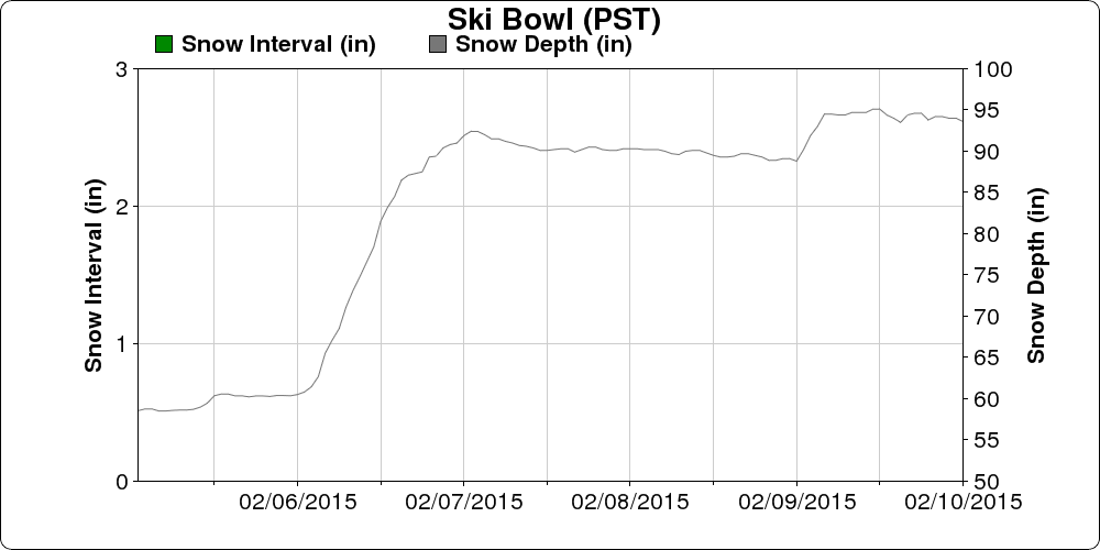
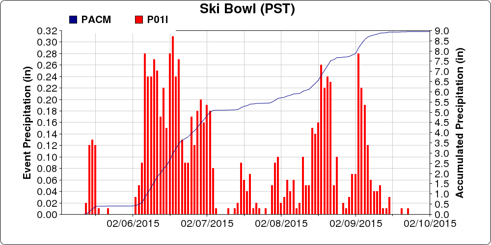
Just to wrap up this particular thread: Mount Shasta Old Ski Bowl at 7600 ft got another 1-2 ft of heavy wet snow, along with periods of rain, during the latter half of the latest atmospheric river cycle. Snowdepth peaked at 95" on Monday, February 9, and total precip during the cycle was almost 9":
The California Cooperative Snow Surveys telemetry site on Lassen Peak at 8250 ft near Lake Helen also got about 1-2 ft of heavy wet snow, along with periods of rain, during the latter half of the cycle. It's now just barely ahead of the Shasta site with 96", once again the deepest current snowpack of any measurement site in California. While Shasta Old Ski Bowl is right about 100% of normal for this date, the normally much-snowier Lassen site is only about 75% of normal now.
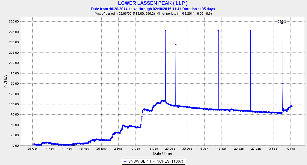
Here is the snowdepth at Lassen over this season (ignore the 200+" data glitches), of particular note is the almost complete lack of snowfall from December 21 throughout the entire month of January and up to February 6, followed by the recent snowfall:
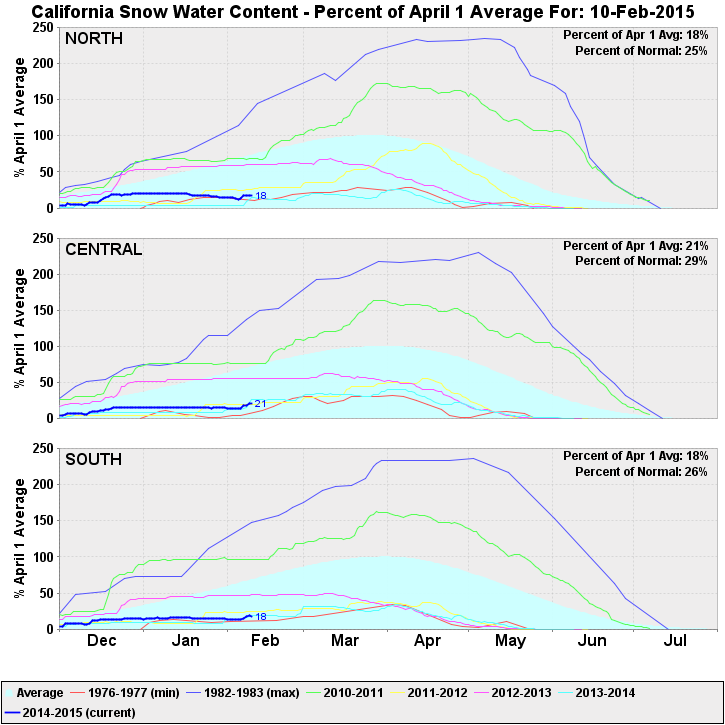
Despite a slight boost at high elevations from this very warm and wet atmospheric river cycle, the overall snowpack in California remains disastrously bad and just above record lows for this date (for real, not hyperbole like in WA!). This plot shows the snowpack throughout the state for this season, and also the last several since the huge 2010-2011 season, just prior to the onset of this historically unprecedented California drought, which is now well into its 4th year. All the heavy rain down there several times this season has not been nearly enough to break the drought. Current snowpack in all 3 regions is comparable to last year's miserable levels, and just barely above the record lows of 1976-77:
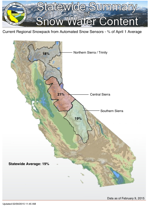
This map makes it easier to visualize the 3 regions in the plot above (note that percentages shown are relative to April 1 normals):
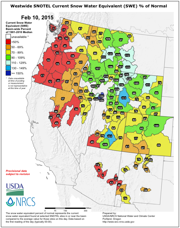
What does the situation in the rest of the western US look like? Here is a view of snowpack conditions from the SNOTEL network throughout the west, current snowpack (snow water equivalent) as a percent of normal remains below-normal in the Northwest. The situation has gotten much worse since early January, now far below-normal throughout almost the entire Cascade Range (except parts of the North Cascades) and even worse in the Olympics. It's really bad, but still not near record lows for this date in the WA Cascades -- it is much closer to record lows in the Olympics and Oregon Cascades:
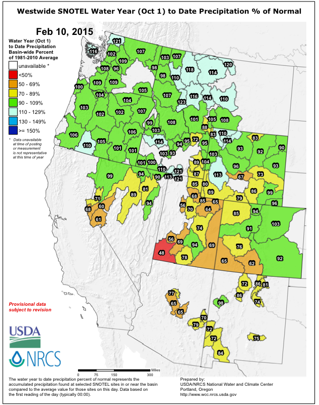
Water year to date precipitation (since Oct 1) as a percent of normal, which in sharp contrast to SWE remains slightly above-normal throughout the Northwest, just as it was in December and January. At least we are very fortunate to not be dealing with drought:
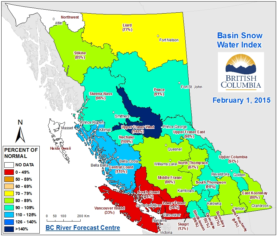
What about farther north? The BC River Forecast Centre just released its February 1 snowpack report (daily updated maps are not available for BC, only once a month), and the snowpack in southwestern BC is also far below-normal, while most of the rest of the province is closer to normal. The central and northern Coast Mountains are slightly above normal, in sharp contrast to the southern parts of the same range:
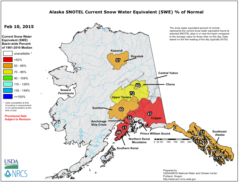
How about even farther north? Alaska is also suffering through a far below-normal snowpack season especially in the coastal mountain ranges, worst in south-central Alaska and only slightly better in southeast Alaska. Current snowpack (snow water equivalent) as a percent of normal from the SNOTEL network:
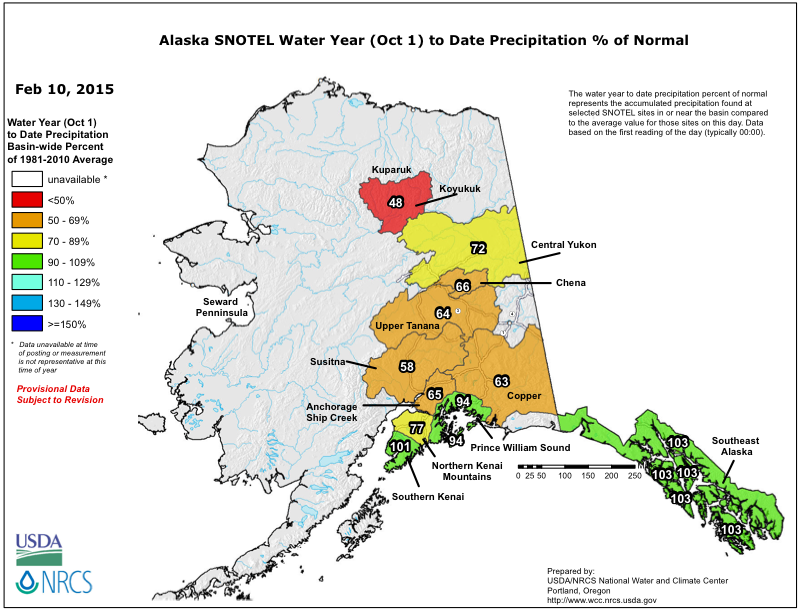
Water year to date precipitation (since Oct 1) as a percent of normal, which in sharp contrast to SWE remains closer to normal throughout most of coastal Alaska, just as in the Pacific Northwest:
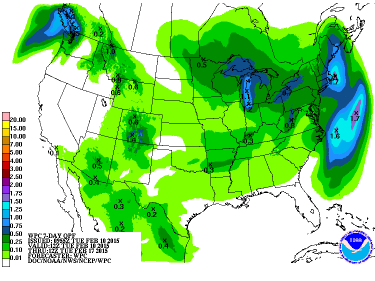
What's coming next? Very little precip is forecast over the western US for the next week, other than a moderate system in southern Colorado the next couple days and another weak atmospheric river aimed into southwestern BC:
Just to wrap up this particular thread: Mount Shasta Old Ski Bowl at 7600 ft got another 1-2 ft of heavy wet snow, along with periods of rain, during the latter half of the latest atmospheric river cycle. Snowdepth peaked at 95" on Monday, February 9, and total precip during the cycle was almost 9":
The California Cooperative Snow Surveys telemetry site on Lassen Peak at 8250 ft near Lake Helen also got about 1-2 ft of heavy wet snow, along with periods of rain, during the latter half of the cycle. It's now just barely ahead of the Shasta site with 96", once again the deepest current snowpack of any measurement site in California. While Shasta Old Ski Bowl is right about 100% of normal for this date, the normally much-snowier Lassen site is only about 75% of normal now.
Here is the snowdepth at Lassen over this season (ignore the 200+" data glitches), of particular note is the almost complete lack of snowfall from December 21 throughout the entire month of January and up to February 6, followed by the recent snowfall:
Despite a slight boost at high elevations from this very warm and wet atmospheric river cycle, the overall snowpack in California remains disastrously bad and just above record lows for this date (for real, not hyperbole like in WA!). This plot shows the snowpack throughout the state for this season, and also the last several since the huge 2010-2011 season, just prior to the onset of this historically unprecedented California drought, which is now well into its 4th year. All the heavy rain down there several times this season has not been nearly enough to break the drought. Current snowpack in all 3 regions is comparable to last year's miserable levels, and just barely above the record lows of 1976-77:
This map makes it easier to visualize the 3 regions in the plot above (note that percentages shown are relative to April 1 normals):
What does the situation in the rest of the western US look like? Here is a view of snowpack conditions from the SNOTEL network throughout the west, current snowpack (snow water equivalent) as a percent of normal remains below-normal in the Northwest. The situation has gotten much worse since early January, now far below-normal throughout almost the entire Cascade Range (except parts of the North Cascades) and even worse in the Olympics. It's really bad, but still not near record lows for this date in the WA Cascades -- it is much closer to record lows in the Olympics and Oregon Cascades:
Water year to date precipitation (since Oct 1) as a percent of normal, which in sharp contrast to SWE remains slightly above-normal throughout the Northwest, just as it was in December and January. At least we are very fortunate to not be dealing with drought:
What about farther north? The BC River Forecast Centre just released its February 1 snowpack report (daily updated maps are not available for BC, only once a month), and the snowpack in southwestern BC is also far below-normal, while most of the rest of the province is closer to normal. The central and northern Coast Mountains are slightly above normal, in sharp contrast to the southern parts of the same range:
How about even farther north? Alaska is also suffering through a far below-normal snowpack season especially in the coastal mountain ranges, worst in south-central Alaska and only slightly better in southeast Alaska. Current snowpack (snow water equivalent) as a percent of normal from the SNOTEL network:
Water year to date precipitation (since Oct 1) as a percent of normal, which in sharp contrast to SWE remains closer to normal throughout most of coastal Alaska, just as in the Pacific Northwest:
What's coming next? Very little precip is forecast over the western US for the next week, other than a moderate system in southern Colorado the next couple days and another weak atmospheric river aimed into southwestern BC:
Please Log in or Create an account to join the conversation.