- Posts: 635
- Thank you received: 0
Lassen Peak CA reaches 100" snowdepth!! 17Dec2014
- Amar Andalkar
-
 Topic Author
- User
-

Less
More
11 years 3 months ago - 11 years 3 months ago #223301
by Amar Andalkar
Replied by Amar Andalkar on topic Re: Lassen Peak CA reaches 100" snowdepth!! 17Dec2014
Just a little bit of ongoing snowpack news...
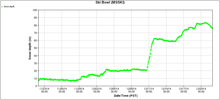
Moderate snowfall continued in the California Cascades during the next 4 days after the original post above, producing an additional foot or so of new snow and one notable milestone on Mount Shasta. The snowdepth at Mount Shasta Old Ski Bowl at 7600 ft reached 83" on December 21, which easily surpasses the maximum depth reached at any point during last season's ongoing drought. The 2013-14 season's snowdepth topped out at only 77" on April 4, 2014, about 55% of the normal early April depth of almost 140" at this site over the 12 years since it was installed. Here are plots of snowdepth and precip over the past 30 days at Mount Shasta Old Ski Bowl, showing the huge December 10-12 storm and ongoing snowfall since then:
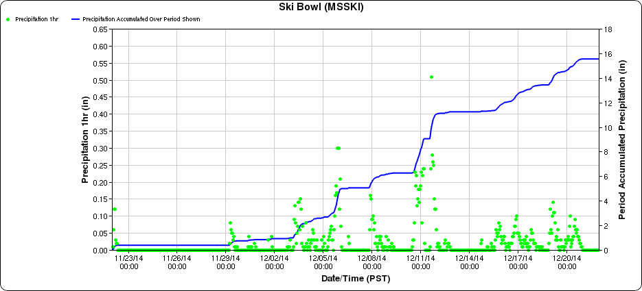
Almost 16" of precipitation in the last 3 weeks (actually about 2" more than that, since some precip was missed by the gauge in the middle of the huge snowstorm) should go a long way toward easing drought conditions. Down in Mount Shasta city at 3500 ft, there has been about 12.5" of precip thus far in December, about 250% of the normal of 5" by this time of the month.
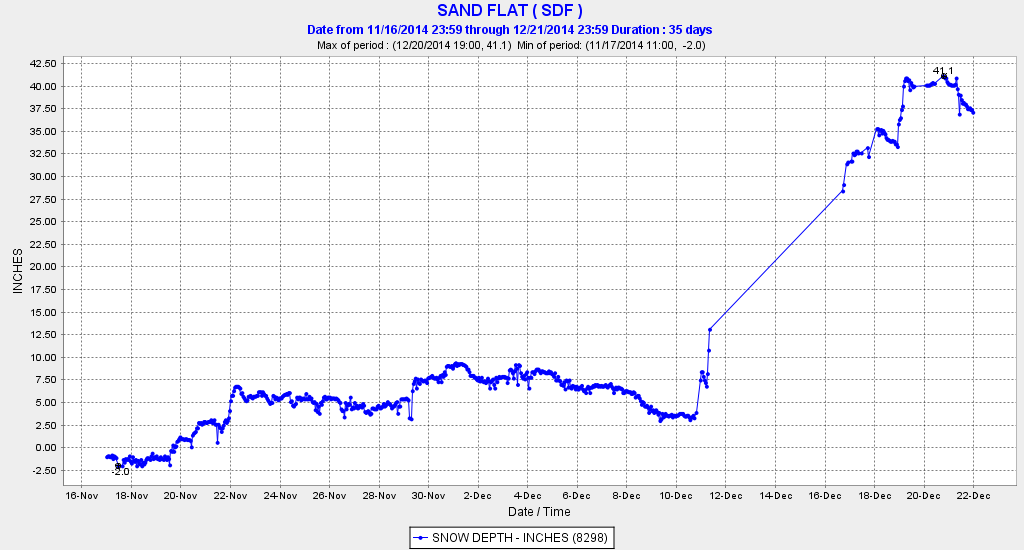
Lower down on the mountain, the snowpack has built up rapidly down to about 5500 ft during the most recent storms, after getting mostly rain during the huge December 10-12 system. The snowdepth reached 41" on December 21 at the CCSS telemetry site at Sand Flat at 6750 ft, and 25" at the base of the Mount Shasta Ski Park at 5500 ft. Here is the snowdepth at Sand Flat over the past month, unfortunately there was a data outage during the huge snowstorm, but thankfully the site came back online afterwards:
The Ski Park opened for the season on December 20, and things look much more hopeful than last year, during which the ski area only operated for about 3 days from December 26-28 and apparently never reopened the rest of the season. Although that was a truly nightmarish season by any standard, the nearby Mt Ashland Ski Area about 70 miles north up I-5 just over the Oregon border had an even worse year, never opening at all for the first time in its 50 year history. It's nice to see that this community-owned non-profit ski area managed to open for skiing on December 19 through the weekend, although snowpack remains marginal there and continued operation depends on additional snowfall.
The ongoing snowfall brought snowdepth at the 8250 ft Lassen Peak site up to 109" on December 20, which is within striking distance of the maximum depth reached last year. Although as mentioned above that site suffered a season-long data outage last year, the monthly snow course measurements showed 122" on April 2, 2014, which should have been fairly close to the seasonal maximum. Current snowdepth at the southwest entrance visitor center of Lassen Volcanic National Park (6700 ft) is about 60", with 14" at the very rain-shadowed Manzanita Lake (5800 ft) near the northwest entrance of the park and 6" at park headquarters in Mineral (5000 ft), several miles SW of the park itself.
And closer to home, although there's still a long way to go to reach normal depths, at least there's a real snowpack now at most measurement sites above 3000-4000 ft in the Washington Cascades and 5000-6000 ft in the Oregon Cascades, a sharp contrast to only a week ago when the bleak December 15 numbers came out. Mount Rainier Paradise reached 44" on December 20 (about 60% of normal for that date) and Mount Baker Ski Area reached 34" (still only 45% of normal, but vastly better than 6" last week). The SNOTEL data server has been offline all weekend, so there's been no way to check the snowpack at the Harts Pass SNOTEL site which had Washington's deepest snowpack a few days ago.
The deepest snowpack in Oregon is at Mount Bachelor, which reached 45" at its 6350 ft base and 73" at its 7300 ft mid-mountain snow stake on December 20 following 2 ft of recent snowfall. At Crater Lake National Park headquarters (6400 ft), snowdepth reached 40" on December 20 (78% of normal for the date) also after 2 ft of recent snowfall, with 50" at the Crater Lake Rim site (7050 ft).
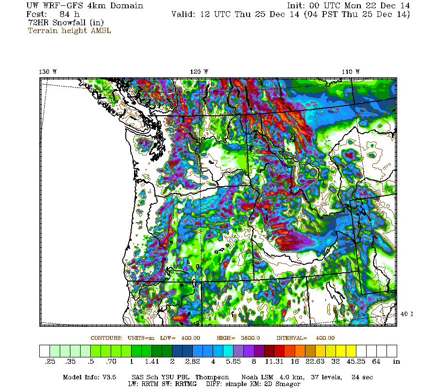
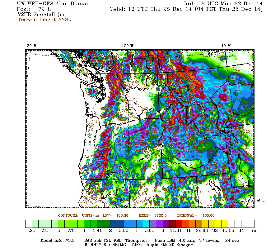
There has been some settlement during the rainy portion of the system Saturday overnight into Sunday, but renewed snowfall late Sunday is once again building snowdepths in the Washington and northern Oregon Cascades, and additional snowfall is expected on Tuesday-Wednesday. The current run of the high-resolution UW WRF-GFS model predicts moderate snowfall amounts of up to 1 ft over the entire length of the Cascade Range and into the northern Sierra Nevada during the 72-hour period through Thursday morning:
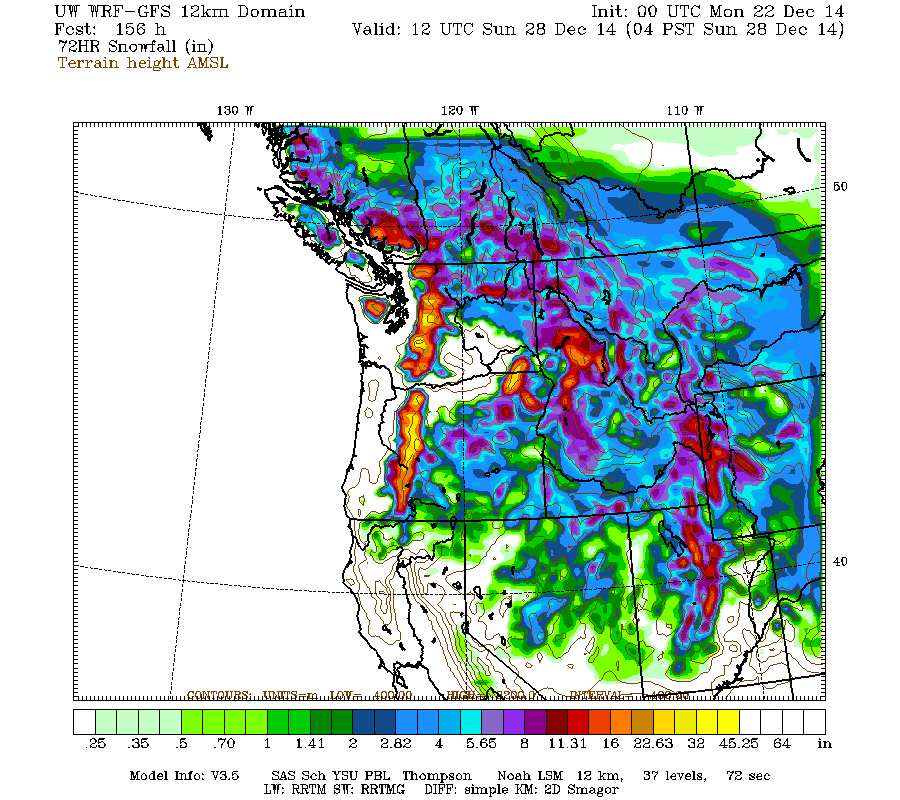
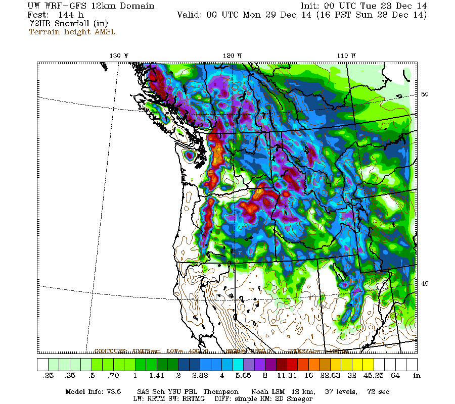
There's also the chance of a more potent snowstorm on Friday-Saturday, although models remain uncertain and confidence is not high yet. Snowfall amounts of up to 2-3 ft over the Washington and Oregon Cascades are predicted for the next 72-hour period through Sunday morning:
If that prediction actually pans out, then snowdepths will have recovered to near-normal values throughout most of the Cascade Range by the end of that storm.
Moderate snowfall continued in the California Cascades during the next 4 days after the original post above, producing an additional foot or so of new snow and one notable milestone on Mount Shasta. The snowdepth at Mount Shasta Old Ski Bowl at 7600 ft reached 83" on December 21, which easily surpasses the maximum depth reached at any point during last season's ongoing drought. The 2013-14 season's snowdepth topped out at only 77" on April 4, 2014, about 55% of the normal early April depth of almost 140" at this site over the 12 years since it was installed. Here are plots of snowdepth and precip over the past 30 days at Mount Shasta Old Ski Bowl, showing the huge December 10-12 storm and ongoing snowfall since then:
Almost 16" of precipitation in the last 3 weeks (actually about 2" more than that, since some precip was missed by the gauge in the middle of the huge snowstorm) should go a long way toward easing drought conditions. Down in Mount Shasta city at 3500 ft, there has been about 12.5" of precip thus far in December, about 250% of the normal of 5" by this time of the month.
Lower down on the mountain, the snowpack has built up rapidly down to about 5500 ft during the most recent storms, after getting mostly rain during the huge December 10-12 system. The snowdepth reached 41" on December 21 at the CCSS telemetry site at Sand Flat at 6750 ft, and 25" at the base of the Mount Shasta Ski Park at 5500 ft. Here is the snowdepth at Sand Flat over the past month, unfortunately there was a data outage during the huge snowstorm, but thankfully the site came back online afterwards:
The Ski Park opened for the season on December 20, and things look much more hopeful than last year, during which the ski area only operated for about 3 days from December 26-28 and apparently never reopened the rest of the season. Although that was a truly nightmarish season by any standard, the nearby Mt Ashland Ski Area about 70 miles north up I-5 just over the Oregon border had an even worse year, never opening at all for the first time in its 50 year history. It's nice to see that this community-owned non-profit ski area managed to open for skiing on December 19 through the weekend, although snowpack remains marginal there and continued operation depends on additional snowfall.
The ongoing snowfall brought snowdepth at the 8250 ft Lassen Peak site up to 109" on December 20, which is within striking distance of the maximum depth reached last year. Although as mentioned above that site suffered a season-long data outage last year, the monthly snow course measurements showed 122" on April 2, 2014, which should have been fairly close to the seasonal maximum. Current snowdepth at the southwest entrance visitor center of Lassen Volcanic National Park (6700 ft) is about 60", with 14" at the very rain-shadowed Manzanita Lake (5800 ft) near the northwest entrance of the park and 6" at park headquarters in Mineral (5000 ft), several miles SW of the park itself.
And closer to home, although there's still a long way to go to reach normal depths, at least there's a real snowpack now at most measurement sites above 3000-4000 ft in the Washington Cascades and 5000-6000 ft in the Oregon Cascades, a sharp contrast to only a week ago when the bleak December 15 numbers came out. Mount Rainier Paradise reached 44" on December 20 (about 60% of normal for that date) and Mount Baker Ski Area reached 34" (still only 45% of normal, but vastly better than 6" last week). The SNOTEL data server has been offline all weekend, so there's been no way to check the snowpack at the Harts Pass SNOTEL site which had Washington's deepest snowpack a few days ago.
The deepest snowpack in Oregon is at Mount Bachelor, which reached 45" at its 6350 ft base and 73" at its 7300 ft mid-mountain snow stake on December 20 following 2 ft of recent snowfall. At Crater Lake National Park headquarters (6400 ft), snowdepth reached 40" on December 20 (78% of normal for the date) also after 2 ft of recent snowfall, with 50" at the Crater Lake Rim site (7050 ft).
There has been some settlement during the rainy portion of the system Saturday overnight into Sunday, but renewed snowfall late Sunday is once again building snowdepths in the Washington and northern Oregon Cascades, and additional snowfall is expected on Tuesday-Wednesday. The current run of the high-resolution UW WRF-GFS model predicts moderate snowfall amounts of up to 1 ft over the entire length of the Cascade Range and into the northern Sierra Nevada during the 72-hour period through Thursday morning:
There's also the chance of a more potent snowstorm on Friday-Saturday, although models remain uncertain and confidence is not high yet. Snowfall amounts of up to 2-3 ft over the Washington and Oregon Cascades are predicted for the next 72-hour period through Sunday morning:
If that prediction actually pans out, then snowdepths will have recovered to near-normal values throughout most of the Cascade Range by the end of that storm.
Please Log in or Create an account to join the conversation.
- snoholic
-
- User
-
Less
More
- Posts: 120
- Thank you received: 1
11 years 3 months ago #223302
by snoholic
Replied by snoholic on topic Re: Lassen Peak CA reaches 100" snowdepth!! 17Dec2014
Sounds promising, fingers crossed.
Please Log in or Create an account to join the conversation.
- Amar Andalkar
-
Topic Author
- User
-
Less
More
- Posts: 635
- Thank you received: 0
11 years 3 months ago - 11 years 3 months ago #223311
by Amar Andalkar
Replied by Amar Andalkar on topic Re: Lassen Peak CA reaches 100" snowdepth!! 17Dec2014
The SNOTEL data server finally started working again on Monday afternoon, following an extended outage throughout the weekend, so some of the data missing from last night's post can now be found.
The greatest current snowdepth of any telemetry site in Washington or Oregon is still at the Harts Pass SNOTEL at 6500 ft, which reached 73" early on Monday December 22 after continued light snowfall overnight. In close 2nd place is the Lyman Lake SNOTEL at 5900 ft, which reached 70" around the same time. The Harts Pass site remains among the very few sites with above-normal snowpack with about 120% of normal SWE, while the Lyman Lake site is at about 85% of normal SWE (it is normally much snowier than Harts Pass).
The reasonably fat snowpack in the eastern North Cascades is not confined only to higher elevations either, as several sites at lower elevations have substantial snowpacks too. The Trinity SNOTEL at 2900 ft reached 41" early Sunday, roughly the same snowpack as Mount Rainier Paradise right now (!), and probably above-normal for this date -- but the Trinity SNOTEL was just installed in 2010, so normal values are not yet known. Holden Village at 3200 ft had 30" on Sunday (manual measurement), about 80% of normal for that date, while Mazama at 2200 ft reported 21" on the manual measurement (115% of normal) with the NWAC telemetry site briefly reaching 20".
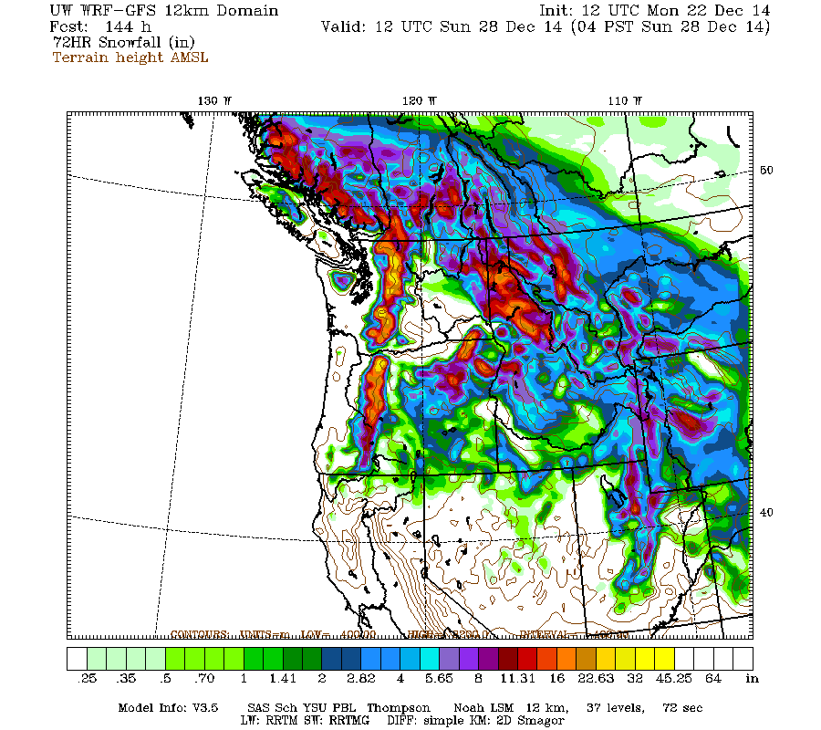
The upcoming weather forecast continues to look promising! This morning's run of the UW WRF-GFS model continued to predict heavy snowfall for the Cascades on Tuesday night into Wednesday (after some warm rain on Tuesday), and an even stronger system for Friday-Saturday, with much lower snow levels and no warm rain. Here are the same plots as the previous post, from this morning's model run, both looking very similar to yesterday:
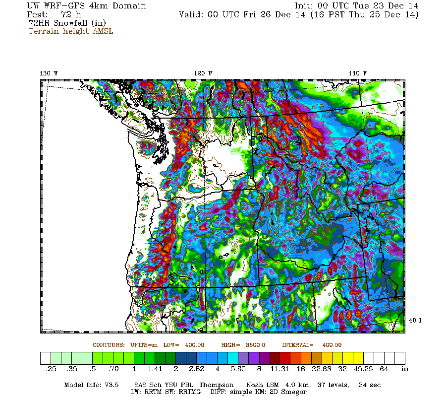
Late evening update: The evening model run is still showing the same general story, with perhaps a bit more snow now predicted during the first system, and maybe a bit less during the second, especially in Oregon (note that these graphics are shifted forward by 12 hours from the previous 2 pairs above):
Overall, the consistency over the past 3 UW model runs since yesterday has been fairly good, although the NWS forecast discussion mentions other issues far out over the Pacific which are causing problems for the global weather models.
The greatest current snowdepth of any telemetry site in Washington or Oregon is still at the Harts Pass SNOTEL at 6500 ft, which reached 73" early on Monday December 22 after continued light snowfall overnight. In close 2nd place is the Lyman Lake SNOTEL at 5900 ft, which reached 70" around the same time. The Harts Pass site remains among the very few sites with above-normal snowpack with about 120% of normal SWE, while the Lyman Lake site is at about 85% of normal SWE (it is normally much snowier than Harts Pass).
The reasonably fat snowpack in the eastern North Cascades is not confined only to higher elevations either, as several sites at lower elevations have substantial snowpacks too. The Trinity SNOTEL at 2900 ft reached 41" early Sunday, roughly the same snowpack as Mount Rainier Paradise right now (!), and probably above-normal for this date -- but the Trinity SNOTEL was just installed in 2010, so normal values are not yet known. Holden Village at 3200 ft had 30" on Sunday (manual measurement), about 80% of normal for that date, while Mazama at 2200 ft reported 21" on the manual measurement (115% of normal) with the NWAC telemetry site briefly reaching 20".
The upcoming weather forecast continues to look promising! This morning's run of the UW WRF-GFS model continued to predict heavy snowfall for the Cascades on Tuesday night into Wednesday (after some warm rain on Tuesday), and an even stronger system for Friday-Saturday, with much lower snow levels and no warm rain. Here are the same plots as the previous post, from this morning's model run, both looking very similar to yesterday:
Late evening update: The evening model run is still showing the same general story, with perhaps a bit more snow now predicted during the first system, and maybe a bit less during the second, especially in Oregon (note that these graphics are shifted forward by 12 hours from the previous 2 pairs above):
Overall, the consistency over the past 3 UW model runs since yesterday has been fairly good, although the NWS forecast discussion mentions other issues far out over the Pacific which are causing problems for the global weather models.
Please Log in or Create an account to join the conversation.